Members and Supporters, the MountainViews Committee requests your help to meet the costs of the website and of other activities such as insured events or publications.
Feature count in area: 20, all in Kerry,
OSI/LPS Maps: 70, 78, 83, EW-R
Highest Place: Coomacarrea 772m
Starting Places (24) in area Glenbeigh Horseshoe: Ballaghasheen Coilte, Ballaghasheen Pass Viewpoint, Cahernaman, Caunoge Boreen, Cloon Lough NE, Cloon Lough SE, Coolnahornan Bridge, Coomaclarig Bridge, Coomaglaslaw Outflow, Coomasaharn Lake, Coosatemple Cove, Coulagh Bridge Road, Drung Hill Layby, Gleensk Forest, Gleensk Viaduct, Glenbeigh Village, Lissatinnig Bridge Boreen, Lough Brista Wood, Lough Cappanlea OEC, Lough Caragh SW, River Behy Road, River Ferta Source, River Owroe Source, Roads Lough
Summits & other features in area Glenbeigh Horseshoe: Cen: Glenbeigh Horseshoe: Been Hill 651m, Beenmore 660m, Beenreagh 495m, Coomacarrea 772m, Drung Hill 640m, Keamconneragh 593m, Macklaun 607m, Meenteog 715m, Mullaghnarakill 665m, Teeromoyle Mountain 760m N: Glenbeigh: Callahaniska 219m, Coolroe 414m, Curra Hill 275m, Seefin 493m S: Caunoge: Caunoge 502m S: Knocknagapple: Colly 679m, Knocknagapple 466m, Knocknagapple NW Top 458m, Meenteog South-East Top 565m W: Mount Foley: Mount Foley 355m
Note: this list of places may include island features such as summits, but not
islands as such.
Meenteog, 715mMountain Muing A name in Irish,
Place Rating ..
(Ir. Muing [SWoI], 'boggy area with long grass'), Kerry County in Munster province, in Arderin, Vandeleur-Lynam, Irish Best Hundred, Irish Highest Hundred Lists, Meenteog is the third highest mountain in the Glenbeigh Horseshoe area and the 102nd highest in Ireland.
Grid Reference V63794 82658,
OS 1:50k mapsheet 78/83 Place visited by: 220members, recently by: rhw, orlaithfitz, maoris, ToughSoles, Krzysztof_K, SeanPurcell, overthehill67, bagoff, Beti13, Oscar-mckinney, NualaB, Carolyn105, Blackstar, Kiwitrekker, Moses
I visited this place: NO (You need to be a logged-in member for this.)
Longitude: -9.983537, Latitude: 51.979674, Easting: 63794, Northing: 82658,
Prominence: 110m, Isolation: 1.2km ITM: 463744 582704 Bedrock type: Purple mudstone & siltstone, (Valentia Slate Formation) Notes on name: Muing is originally the dative form of mong (hair; figuratively: thick growth of grass, fen, morass, swamp), often used as the nominative. However, on the Discovery map this peak is named Meenteog. This could derive from Mínteog, meaning 'small area of pasture'. There is a townland near Barraduff called Meentoges, seemingly of the same origin.
Short or GPS IDs, 6 char: Mntg, 10 char: Meenteog Linkback: https://mountainviews.ie/summit/99/
Gallery for Meenteog (Muing) and surrounds
Summary
for Meenteog (Muing):
Squat and steep-sided summit on Glenbeigh Horseshoe
Summary created by simon3, markmjcampion, Peter Walker
2022-09-15 07:31:32
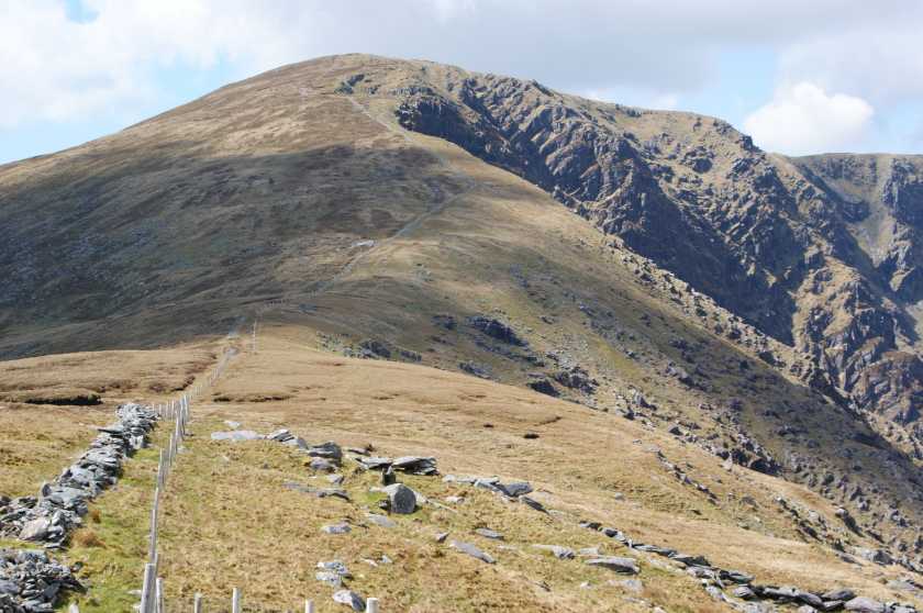
Picture: Meenteog from the east
Meenteog is a broad-topped hill lying above some great coums among the Glenbeigh hills and is often walked as part of various circuits around these hills. There's plenty of v. steep ground to the N so care needs to be taken in poor conditions. Widespread views abound from the vicinity of the summit and these incl. local dramatic cliffs and lakes as well as the Reeks, Dunkerron hills and over to the coast.
N. Park carefully at CumSah L (V63600 85099) and head up the steep slopes of Knocknaman while fine views open up over Coomsaharn Lake and its adjacent crags. The steepness eases when you reach K and it's a relatively handy walk over bog to M from here. Allow 90 mins.
From the same starting point you can also ascend Macklaun first and then head SW to Meenteog although the going between the two summits is v. boggy and full of tall peat hags.
If you're intending continuing on to some of the other Glenbeigh hills it's best to do some research esp.if looking for exits or escape routes to the N.
SE. You can also approach this hill by parking at the roomy Ballaghisheen Gap [BSheen Ps (V67082 79147)} and heading first over the Knocknagapple tops, then Colly and Meenteog East Top before summiting. Allow 2hrs
S. One can start from the farm at the head of Coomaspeara (Owroe Rv (V63385 80843)) and follow the prominent track to the col N of Colly before heading north along the ridge over Meenteog's SE Top to the main summit. Allow 2 hrs. Note. We understand that a landowner now (2022) objects to walkers coming this way.
Notable tracks include track/3233, track/3095 and track/2720.
You can reach Meenteog from its northern ridge, Knocknaman using the small amount of parking around CumSah L (V636 851). The route steeply ascends above Coomsaharn Lake and is variously described in guidebooks. Lyrically by Seán Ó Súilleabháin [Walk Guide Southwest of Ireland], punctiliously by David Herman [Hill Walkers Kerry] and perfunctorily by Paddy Dillon [The Mountains of Ireland]. Perhaps however you plan to reach it from either side on the ridge which doesn't require any literary engagement..
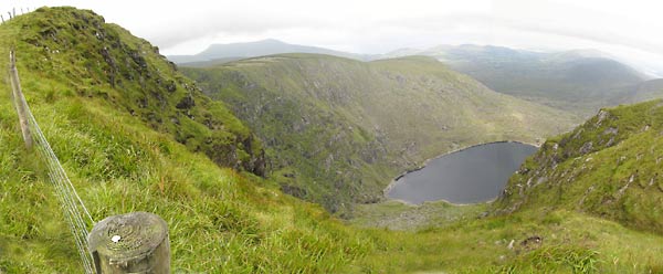
To the north-east and west of it are two great coums, respectively Coomeeneeragh and Coomacullen both very enclosed and full of rotten rock with no walking route. Plan your walking around here and other parts of the Glenbeigh Horseshoe to take into account the possibility of exposure, mist and the need to find a safe way down. A GPS, provided you know how to use it, is a great help. Use the waypoints for all of the summits which are downloadable from this site.
The photo shows Coomeeneragh Lake. The fence leads to the summit of Meenteog, while the ridge on the other side of the lake is Knocknaman. On the skyline above Knocknaman is Beenmore and Drung hill, looking as if Beenmore to the left is lower than Drung. Not so. It's just distortion in this rather extreme wideangle pic. Anyway, if you are doing the full circuit, clockwise, that's where you will eventually get to. Linkback: mountainviews.ie/summit/99/comment/1863/
Read Less
Read More
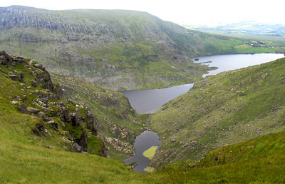
Picture: Coomacullen Lough in front of Coomasharn Lake.
simon3 on Meenteog
by simon3
7 Aug 2005
The summit of Meenteog, known locally according to Seán Ó Súilleabháin as Muing, is rough and flat and didn't seem to have a cairn on it. Apart from the various corrie lakes there's also a good view towards Colly mountain 2.3k to the SE, considered by Richard Mersey [The Hills of Cork and Kerry] to be "the finest of the Glenbeigh peaks" (though he didn't say why).
The photo shows Coomacullen Lough, nearer, and Coomasaharn Lake. Coomacullen appears to have substantial algal bloom growing in it from the look of this picture. Coomasaharn is over 2k long and is home to an unusual form of fish, the Arctic char. "The Coomasaharn char are notable as they differ from other members of the species by the fact that they have completely differently shaped heads and a greater number of filtering structures in their gills. They are also a dwarf form which some scientists believe are related to Siberian char." There's more at http://www.charr.org/, much more. In fact there is a whole group devoted to the preservation of Irish Char. Linkback: mountainviews.ie/summit/99/comment/1864/
Read Less
Read More
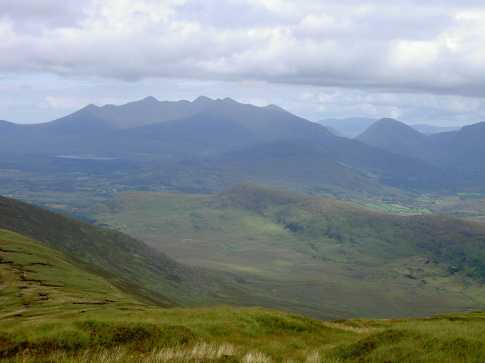
Picture: Cummernabarnadarriga Glen
eric on Meenteog
by eric
16 May 2006
On approaching Meenteog from Colly take a look east in Cummernabarnadarriga Glen. Visible in this photograph are the Reeks, Broaghnabinnia and Lough Acoose. Macklaun is further along the ridge seen on the left in the photograph. Linkback: mountainviews.ie/summit/99/comment/2347/
Read Less
Read More
Picture: Looking back to Meenteog from Coomacarrea, with Coomasaharn Lake lying below.
Via Knocknaman
by FiachDubh
23 Feb 2011
Climbed Meenteog as part of a circuit of Coomsaharn Lake. Parked at an old house ruin (A (V63687 85201)) at roadside and followed a farm track through a small gate to climb the steep, craggy slopes of Knocknaman and then up the squelchy ridge. Great views of the steep back wall of the corrie of Coomeneragh Lake were promised as we approached the summit only to be hidden by the sudden arrival of mist, though that did not last long.
The photo taken on Coomacarrea, looking back to Meenteog, shows Coomasaharn Lake nestling below the Knocknaman ridge, with the Reeks in the distance. Linkback: mountainviews.ie/summit/99/comment/6251/
Use of MountainViews is governed by conditions and a privacy policy.
Read general information about the site. Opinions in material here are not necessarily endorsed by MountainViews.
Hillwalking is a risk sport. Information in comments, walks, shared GPS tracks or about starting places may
not be accurate for example as regards safety or access permission. You are responsible for your safety and your permission to walk.
See the credits and list definitions.


 Our Facebook page.