Donation Request 2024

DONATE
Members and Supporters, the MountainViews Committee requests your help to meet the costs of the website and of other activities such as insured events or publications.
You do not have to be logged in to donate.
Features
Nearby features appear when you click the map.
Declutter tracks on map.
Place Search
Video
X
Pub: by
Iveragh NW Area , N: Killelan Subarea
Feature count in area: 18, all in Kerry, OSI/LPS Maps: 83, 84
Highest Place: Knocknadobar 690m

Starting Places (15) in area Iveragh NW:
Cahernaman, Cahersiveen, Cnoc na dTobar Pilgrims Path, Coonanna Harbour, Cooncrome Harbour, Coosatemple Cove, Coulagh Bridge Road, unuseableCúm an Easpaig, Ducalla, Killurly SW, Kimego Forest E, Puffin Island, Roads Lough, Tetrapod CP, Villa Nuovo

Summits & other features in area Iveragh NW:
Cen: Cahirsiveen: Beenduff 479m, Beentee 376m, Foilclogh 497m
N: Castlequin: Castlequin 361m
N: Killelan: Killelan Mountain 275m
N: Knocknadobar: Kells Mountain 633m, Kells Mountain East Top 612m, Knocknadobar 690m, Knocknadobar North Top 602m
SW: Ballinskelligs: Bolus 410m, Killurly 331m
SW: Portmagee: Formaoil 206m, Knocknaskereighta 395m, Puffin Island 159m
SW: Skelligs: Skellig Rock Little 131m, Skellig Michael 217m
SW: Valentia: Bray Head 239m, Geokaun (Valentia Island) 266m

Note: this list of places may include island features such as summits, but not islands as such.
Rating graphic.
Killelan Mountain, 275m Hill Cnoc Chill Fhaoláin A name in Irish,
Place Rating ..
, Kerry County in Munster province, in Binnion Lists, Killelan Mountain is the 1226th highest place in Ireland.
Grid Reference V41500 80800, OS 1:50k mapsheet 83
Place visited by: 23 members, recently by: garrettd, annem, chelman7, maoris, eamonoc, fingalscave, Carolyn105, Jai-mckinney, Fergalh, Deise-Man, omurchu, conormcbandon, markmjcampion, ciarraioch, seanachai
I visited this place: NO (You need to be a logged-in member for this.)
Longitude: -10.306456, Latitude: 51.957206, Easting: 41500, Northing: 80800, Prominence: 250m,  Isolation: 4.7km
ITM: 441485 580860
Bedrock type: Conglomerate & pebbly sandstone, (Doulus Head Conglomerate Member)

  Short or GPS IDs, 6 char: KllnMn, 10 char: KllnMntn

Linkback: https://mountainviews.ie/summit/979/
Gallery for Killelan Mountain (Cnoc Chill Fhaoláin) and surrounds
Summary for Killelan Mountain (Cnoc Chill Fhaoláin): What? Another spectacular coastal viewpoint?
Summary created by Peter Walker 2012-06-12 20:06:25
Killelan Mountain is one of numerous tops on the far Iveragh coast offering short climbs rewarded by magnificent prospects both inland and maritime. Proceed north from Cahersiveen over the Valencia River towards White Strand beach with good parking opportunities at A (V434 801) (it may well be possible to park with care as far along as B (V422 802)). If starting from the first grid reference, walk north on the road before turning left to a T junction then turning left again: now follow the road to where it becomes a track through an obvious gate. Slant obliquely uphill across a couple of fields to a smaller gate leading out onto the hill past the obvious network of walls. From here climb directly uphill to the col on the ridge at C (V419 809), and turn left for the summit, one of numerous little outcrops along the ridge.

Killelan Mountain can just as easily be ascended from further along the track if the walker wishes to explore some more of the coast before climbing it.
Linkback: mountainviews.ie/summit/979/comment/5738/
Member Comments for Killelan Mountain (Cnoc Chill Fhaoláin)
Comment create / edit display placeholder

            MountainViews.ie picture about Killelan Mountain (<em>Cnoc Chill Fhaoláin</em>)
Picture: Mountain, sea and sand from Killelan Mountain
Shores of the utmost west...
by Peter Walker 12 Jun 2012
There are very few mediocre climbs in the utmost reaches of Iveragh, and Killelan Mountain certainly isn't one of them. It had been a sodden early afternoon in the hills overlooking Glenbeigh so when the weather cheered up considerably in the afternoon I jumped at the chance of spending some slightly sunnier time aloft.

I also made my way to White Strand, but took a punt on being able to leave the car a bit closer to the ascent. I drove up to the T junction and turned left, making my way to the end of the road where I found the gate open and a couple of cars already parked on the right B (V422 802). Setting off on a rising traverse line west across the fields, I was soon greeted by a couple of friendly collies so stopped to chat to their owner (who was parked higher up). Aware that I'd parked a bit further on than my MV predecessors I thought it prudent to check that there weren't any issues with parking and access. I pointed down to my car, looked up the hill and said:

'Am I alright to go up there sir'?

Whereupon the charming elderly gent looked me up and down, and with a twinkle in his eye replied:

'Aye, you look like a fit and healthy young man. I'm sure you can do it.'

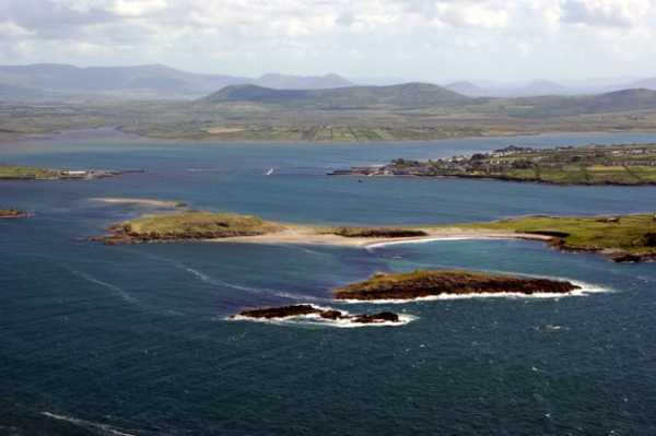
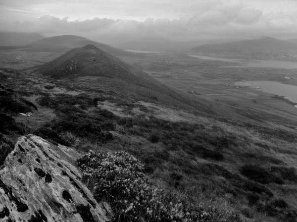
Suitably endorsed I followed his suggested route through a small gate across and slightly up the field to the west, which led me out onto the hillside and clear of the network of walls that pattern the slope until this point. From here I elected to go pretty much straight up, using the last of the walls as a rough guide. This was reasonably straightforward (although shorts-wearers might like to know that there's a fair amount of shin-height prickliness to cross) and led without incident to the col between the hill's twin tops. Turning left the walk to the summit was easy, with assorted vague trods being scarcely necessary as the ridge becomes reasonably well defined. The top is wonderfully airy, with hints of outcropping rock and a gorgeous 360 degree panorama.

Like everything in this neck of the woods (even Geokaun), highly recommended. Linkback: mountainviews.ie/summit/979/comment/6858/
Read Less
Read More

Walking World Ireland Route
by davidhorkan 11 Sep 2012
On Sat 3rd Oct 2009 a group of us walked Killelan.Getting there is easy. In mid town Cahersiveen take the road for White Strand. Plenty of parking there.You walk back along this road , going N & then sharp left & W . Go out to the tip of Doulus Head on well marked sheep tracks & dont miss the sea stacks at Illaunanesk.. Turn here & follow tracks up Killelan.

We are deeply indebted to Tom Hutton who had just published a great article on this walk in the Oct/Nov issue of Walking World Ireland no 93. The views from the top of Killelan 267 m are brilliant including Skelligs & Dingle Bay. Continue on via the fences & stone walls that are very useful physical guide references here. This area is subject to mist& light rain & we were using compass & Map (OS 83 ).Next stop was Coonchrome Harbour. You are on tarmac all the way back to White Strand. There are two renovated forts here , really worth a diversion , especially the Cahergal one. Linkback: mountainviews.ie/summit/979/comment/4222/
Read Less
Read More

            MountainViews.ie picture about Killelan Mountain (<em>Cnoc Chill Fhaoláin</em>)
Picture: View from the summit
A quickie before tea
by three5four0 28 Sep 2011
Where the road from Cahersiven to white strand beach reaches the last junction, at D (V434 800), turn right instead of left for white strand. Within a short distance there will be an area on your left (seaward side) where you can park a couple of cars.

From here take the first left, then left again when this minor road reaches a t junction. Follow this road, which turns into a track, through a couple of gates and past the last wall onto the open hillside. From the last gate - & wall - strike up hill, through a small patch of furze at mid height, gaining the col between the two summits of Killelan Mountain and accessing both tops from here. Linkback: mountainviews.ie/summit/979/comment/6545/
Read Less
Read More
EDIT Point of Interest
text
Videos

Recent Contributions
x
Conditions and Info
Use of MountainViews is governed by conditions and a privacy policy.
Read general information about the site.
Opinions in material here are not necessarily endorsed by MountainViews.
Hillwalking is a risk sport. Information in comments, walks, shared GPS tracks or about starting places may not be accurate for example as regards safety or access permission. You are responsible for your safety and your permission to walk.
See the credits and list definitions.

OSi logo
OSNI/LPS logo
Open Street Map
(Various variations used.)
British summit data courtesy:
Database of British & Irish Hills