This website uses cookies, which are small text files that the website puts on your device to facilitate operation. Cookies help us provide a better service to you. They are used to track general user traffic information and to help the website function properly.
Starting Places (13) in area Ox Mountains: Belra, Glen Wood, Glenwood CP, Kingsmountain Wind Farm, Knockalongy, Largan Hill, Lough Achree, Lough Easkey, Masshill School, Queen Maeve's Grave, Rathcarrick Wood, Slishwood CP, Union Woods CP
Summits & other features in area Ox Mountains: Cen: Annatoran: Annatoran 512m, Cloonacool 440m, Meenamaddo 330m, Sruffaungarve Top 400m Cen: Talt: Knocknasliggaun 417m, Largan Hill 413m, Larganmore 276m Cen: Tobercurry: Knocknashee 276m, Mucklety Hill 217m N: Knockalongy: Cloonagh 349m, Knockalongy 544m, Knockalongy North-East Top 541m, Knockalongy South-West Top 521m N: Sligo Hills: Doomore 272m, Killerry Mountain 293m, Knocknarea 327m, Slieve Daeane 275m, Slieveward 199m
Note: this list of places may include island features such as summits, but not
islands as such.
Knocknashee, 276mHill Cnoc na Sí A name in Irish,
Place Rating ..
(Ir. Cnoc na Sí [logainm.ie], 'hill of the fairies'), Sligo County in Connacht province, in Binnion Lists, Knocknashee is the 1221th highest place in Ireland.
Grid Reference G55600 19200,
OS 1:50k mapsheet 25 Place visited by: 34members, recently by: jlk, andalucia, finkey86, dregish, TommyV, poopoobasto, FilHil, oreills8, TommyMc, Wilderness, Tomaquinas, Welder, FrankMc1964, 40Shades, ColinCallanan
I visited this place: NO (You need to be a logged-in member for this.)
Longitude: -8.67978, Latitude: 54.119991, Easting: 155600, Northing: 319200,
Prominence: 171m, Isolation: 4.5km, Has trig pillar
ITM: 555559 819207 Bedrock type: Bioclastic cherty limestone, (Bricklieve Limestone Formation (upper)) Notes on name: Located in the townland of Knocknashee Common. Ir. sí can mean both 'fairy' and 'fairy mound'. It is usually masculine, and therefore this name appears to mean 'hill of the fairies'. However, since it can occasionally be feminine, the meaning 'hill of the fairy mound' cannot be ruled out.
Short or GPS IDs, 6 char: Knc276, 10 char: Knocknashe Linkback: https://mountainviews.ie/summit/975/
Gallery for Knocknashee (Cnoc na Sí) and surrounds
No summary yet for this place
.
Add a Place Comment for Knocknashee, Cnoc na Sí (975) in Area: Ox Mountains, Cen: Tobercurry, County: Sligo, Cen: Tobercurry
There is plenty of parking at A (G54743 19300), beside a hall / old school. Walked back through the road junction (B (G54756 19190)) and continued along the road opposite till C (G55068 18300), where there are 2 gates. Go through the left one, then another, which has the standard disclaimer sign attached to the wall beside it, and walk up hill through the fields. After stepping over a couple of fences you reach the summit area and after a short walk reach the trig point and burial cairn.
Whilst the Ox Mountains may hold the view, the outlines of other cairns, enclosures etc litter the summit area and are worth seeking out. We returned the way of our ascent Linkback: mountainviews.ie/summit/975/comment/5948/
Read Less
Read More
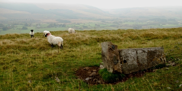
Picture: Once proud but know fallen on hard times Trig.
Trig support required!
by eamonoc
16 Oct 2014
Climbed on 15/10/2014. Started at D (G56332 18935), parked on roadside verge beside some old farm bulidings. Following directions of a Sligo Spur Walks, well made route card was able to ascend easily through two fields to the summit plateau and find Trig point beside megalithic tomb. Poor old trig was lying on it`s side having obviously toppled from burial mound. As this is not the first trig I have discovered in this state of despair, maybe the formation of a Trig Support group would be in order! Linkback: mountainviews.ie/summit/975/comment/17729/
Read Less
Read More
Western Face conqured: July 2000.
by daveespene
6 Mar 2014
We Scaled the Western sheer face in July 2000, directly up to the Trig point area. And descending by sliding most of the way back down, ruined a new pair of jeans in the process, but great fun. Will be going back soon to activate it for(ham radio) Summits On The Air as EI0DB/P. But this time using the easy way in. (dja & pala) Linkback: mountainviews.ie/summit/975/comment/15904/
Read Less
Read More
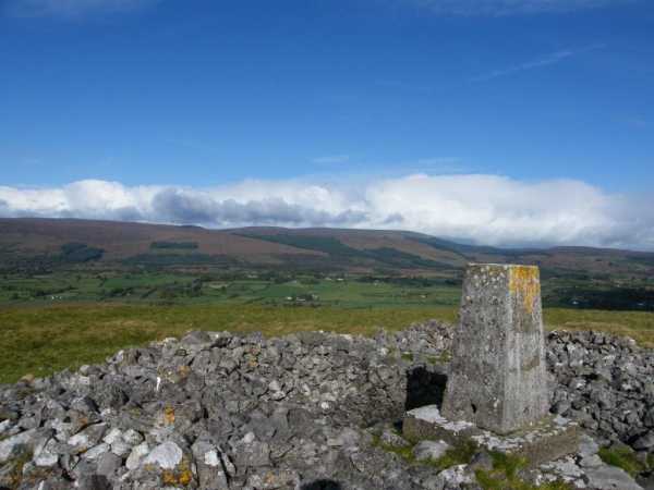
Picture: Knocknashee trig with Ox Mountains behind
paddyhillsbagger on Knocknashee
by paddyhillsbagger
4 Oct 2009
Knocknashee has a pleasing aspect on the small road into Lavagh where I parked at E (G550 185) and followed a fence up the spine of the hill to a flat plateau above. The trig cairn which looks like it has been plonked on a collapsed Megalithic cairn is at the Northern end of the hill so a short walk admiring the fine views of the nearby Ox Mountain range, scaring the resident sheep and enjoying the croaks of a pair of Raven got me there in no time at all. Looking roughly East the bulk of Kesh and it's prominent cairn is clearly visible, pity I missed viewing Knocknashee from there in my cloud covered ascent last month! Linkback: mountainviews.ie/summit/975/comment/4178/
Read Less
Read More
"Hill of the Fairies"
by Jamessheerin
5 May 2017
This hill is known locally as "The Hill of the Fairies". So, perhaps its those little folk who are responsible for the Trig toppling? Great views from on top.. well worth the ramble up if passing by. What better way to break a long journey! Linkback: mountainviews.ie/summit/975/comment/18911/
Use of MountainViews is governed by conditions and a privacy policy.
Read general information about the site. Opinions in material here are not necessarily endorsed by MountainViews.
Hillwalking is a risk sport. Information in comments, walks, shared GPS tracks or about starting places may
not be accurate for example as regards safety or access permission. You are responsible for your safety and your permission to walk.
See the credits and list definitions.


 Add a Place Comment for Knocknashee, Cnoc na Sí


 Our Facebook page.