This website uses cookies, which are small text files that the website puts on your device to facilitate operation. Cookies help us provide a better service to you. They are used to track general user traffic information and to help the website function properly.
Feature count in area: 115, by county: Wicklow: 108, Kildare: 4, Wexford: 2, Carlow: 3, of which 1 is in both Wexford and Wicklow, of which 1 is in both Carlow and Wicklow,
OSI/LPS Maps: 28B, 55, 56, 61, 62, AWW, EW-DM, EW-LG, EW-WE, EW-WS
Highest Place: Lugnaquilla 924.7m
Starting Places (205) in area Wicklow: 1916 Memorial Car Park, Aghavannagh Ow Bridge, Aghowle Wood, Altidore Wood Entrance, Annacurra National School, Annalecka Bridge, Asbawn Brook L8350, Aughrim National School, Ballard Road, Ballinabarny Gap, Ballinagappoge Bridge Layby, Ballinagappoge Mountain Hairpin, Ballinagore, Ballinahinch Wood, Ballinastoe MBT CP, Ballinastraw South, Ballineddan Upr Fork, Ballinfoyle Upr Cross, Ballycoog, Ballycreen Brook Bridge, Ballycumber, Ballycumber Bridge, Ballycumber Lane, Ballycumber Wicklow Way, Ballylerane, Ballylow Bridge, Ballylusk Quarry, Ballymanus Lane, Ballymoyle Shooting Lodge, Ballynultagh Gap, Ballynultagh Lane, Ballyreagh Wood, Ballyross Forest, Ballysmuttan Long Stone, Baravore, Barnbawn South, Barranisky North, Barranisky West, Bohilla Land Roundabout, Bohilla Lane Mid, Boranaraltry Bridge, Bray Harbour, Brewel West, Brittas Bay North CP, Buckroney Sand Dunes CP, Bus Terminus, Camera Hill Track Cross, Castletimon Wood North, Clara Vale, Clone House Road, Clonegal, Cloon Wood Cp, Coate Bridge, Coolballintaggart Ledge, Coolbawn House Lane, Cransillagh Brook , Crone Wood CP, Crossbridge, Crossoona Rath, Cummer Wood South, Curtlestown Wood CP, Deputy's Pass CP, Derralossary Church, Derry River Bridge, Devil's Glen CP, Devil's Glen Wood, Djouce Wood Calary, Djouce Wood Lake, Djouce Wood Long Hill, Donard, Donnelly's Lane Car Sales, Drumgoff Forest, Dunranhill North, Dunranhill SE, Dunranhill South, Dwyer McAllister Cottage CP, Enniskerry, Fentons Pub, Fitzsimons Park GAA, unuseableFlemings Footbridge Glen Rd, Gap Pub, Gap Road, Glen Beach CP, Glen of the Downs CP, Glenbride Lane, Glenbride Lodge, Glencree Reconciliation, Glendalough, Glenealy GAA, Glenmacnass Tonelagee CP, Glenmalure Hostel, Glenmalure Lodge, Glenmalure Waterfall, Glenview Hotel, Gowle House, Great Sugar Loaf CP, Grove Bar, Heffernans Well Wood, Hill View, Hollywood Glen, JB Malone CP, Johnnie Fox Pub, Keadeen NE trail, Keadeen Trailhead, Kevins Way Footbridge, Kilbride Army Camp Entrance, Kilcandra South, Kilcommon View, Killalongford Wood, Kilmacrea Cross Roads, Kilranelagh House Gate, Kilruddery Car Park, Kilruddery Cottages, Kings River, Kippure Bridge, Kippure Estate, Kippure Transmitter Gate, Knickeen Cross, Knocknaboley Lane Leeraghs Bog, Knocknaboley Lane Stone Cottage, Knockrath Little, Knockree west, Kyle Loop North, Lackan Wood S, Lake Dr Fraughan Brook, Lake Drive, Lake Park Cross, Lake View Pub, Laragh Free Car Park, Laragh NSch, Lead Mines CP, Liffey Bridge, Liffey Head Bridge, Lough Bray Lower, Lough Bray Upper, Lough Tay North Viewing Point, Lough Tay Wicklow Way CP, Luglass Lane L97561, Lugnagun Track, Macreddin Village, Mangans Lane, Military Road Carrigshouk Hill, Military Road Inchavore River Nth, Military Road Inchavore River Sth, Military Road NW Lough Tay, Military Road Ballyboy Bridge, Military Road Cloghoge Brook, Military Road Croaghanmoira, Military Road Fananierin, Military Road LaraghWicklow Way, Military Road Slieve Maan, Monspolien Bridge, Moortown House, Mountain Rescue HQ, Muskeagh Little Wood, Nahanagan Lough NE, Novara Avenue, Bray, Oiltiagh Brook Knickeen, Old Bridge Cross, Old Bridge Scouts , Old Wicklow Way entrance, Paddock Hill SE, Pier Gates CP, Powerscourt Waterfall CP, Putland Road, Quintagh East, Raheen Park CP, Raheenleagh East, Railway Walk CP, Rathdrum Railway Station, Rednagh Wood, Rocky Valley, Roundwood, Sally Gap, Sally Gap N, Seefin Trailhead, Seskin SE, Shankill Tributary Bridge, Shay Elliott, Sheepshanks Bridge, Shillelagh, Slievecorragh Track, Slievefoore South, Sraghoe Brook, St John's Church, St Kevins Chair, St Kevins Church, St Kevins Way R756, Stone Circle Bridge, Stookeen South, Stranahely Wood, Stranakelly Cross Roads, Tallyho, Templeboden, Tithewer, Tomcoyle Lower, Tomriland Wood, Toor Brook, Trooperstown Hill Access, Turlough Hill CP, Upper Lake CP, Vallymount GAA CP, Vartry Reservoir Upper, Zellers Pub
Summits & other features in area Wicklow: Cen: Glendalough North: Brockagh Mountain 556.9m, Brockagh Mountain NW Top 549.5m, Brockagh Mountain SE Top 471.7m, Camaderry East Top 677.3m, Camaderry Mountain 698.6m, Conavalla 734m, Tomaneena 682.4m Cen: Glendalough South: Carriglineen Mountain 456.6m, Cullentragh Mountain 510m, Derrybawn Mountain 476.1m, Kirikee Mountain 474.5m, Lugduff 653.2m, Lugduff SE Top 638m, Mullacor 660.7m, Trooperstown Hill 430m N Cen: Tonelagee: Carrignagunneen 561m, Fair Mountain 571.2m, Stoney Top 713.7m, Tonelagee 815.8m, Tonelagee E Top 668m, Tonelagee South-East Top 545.8m NE: Bray & Kilmacanogue: Bray Head Hill 238.9m, Carrigoona Commons East 242m, Downs Hill 372.9m, Great Sugar Loaf 501.2m, Little Sugar Loaf 342.4m NE: Djouce: Djouce 725.5m, Knockree 342.1m, Maulin 570m, Tonduff 642m, Tonduff East Top 593m, War Hill 684.8m, White Hill 631.1m NE: Fancy: Ballinafunshoge 480m, Kanturk 527.4m, Knocknacloghoge 532.4m, Luggala 593.3m, Robber's Pass Hill 508.9m, Scarr 640m, Scarr North-West Top 559.8m, Sleamaine 430m NE: Vartry: Ballinacorbeg 336m, Ballycurry 301m, Dunranhill 342m, Mount Kennedy 365.9m NW: Blessington: Carrigleitrim 408m, Lugnagun 446.2m, Slieveroe 332m, Sorrel Hill 599.5m NW: Mullaghcleevaun: Black Hill 602.2m, Carrigshouk 572.5m, Carrigvore 682.4m, Duff Hill 720.8m, Gravale 719m, Moanbane 703m, Mullaghcleevaun 846.7m, Mullaghcleevaun East Top 796m, Silsean 698m S: Aughrim Hills: Cushbawn 400m, Killeagh 249m, Moneyteige North 427m, Preban Hill 389m S: Croaghanmoira: Ballinacor Mountain 529.3m, Ballycurragh Hill 536m, Ballyteige 447m, Carrickashane Mountain 508m, Croaghanmoira 662.3m, Croaghanmoira North Top 579.5m, Fananierin 426m, Slieve Maan 547.8m, Slieve Maan North Top 546.1m S: Croghan Kinsella: Annagh Hill 454m, Croghan Kinsella 606m, Croghan Kinsella East Top 562.1m, Slievefoore 414m S: Shillelagh Hills: Lakeen 357m, Monaughrim 206m, Seskin 344m, Stookeen 420m S: Tinahely Hills: Ballycumber Hill 429.7m, Eagle Hill 296m, Muskeagh Hill 398.2m SE: Wicklow South East: Ballinastraw 284m, Ballyguile Hill 188m, Barranisky 280m, Carrick Mountain 381m, Collon Hill 238m, Kilnamanagh Hill 217m, Westaston Hill 270m W: Baltinglass: Ballyhook Hill 288m, Baltinglass Hill 382m, Carrig Mountain 571m, Carrigeen Hill 298m, Cloghnagaune 385m, Corballis Hill 258m, Keadeen Mountain 653m, Spinans Hill 409m, Spinans Hill SE Top 400m, Tinoran Hill 312m W: Cen Lugnaquilla: Ballineddan Mountain 652.3m, Benleagh 689m, Camenabologue 758m, Camenabologue SE Top 663m, Cloghernagh 800m, Corrigasleggaun 794.6m, Lugnaquilla 924.7m, Slievemaan 759.7m W: Donard: Brewel Hill 222m, Church Mountain 544m, Corriebracks 531m, Lobawn 636m, Slievecorragh 418m, Sugarloaf 552m, Table Mountain 701.7m, Table Mountain West Top 563m
Note: this list of places may include island features such as summits, but not
islands as such.
Barranisky, 280mHill Barr an Uisce A name in Irish,
Place Rating ..
(prob. Ir. Barr an Uisce [PDT], 'top of the water') Ballymoyle Hill an extra name in English, Wicklow County in Leinster province, in Binnion Lists, Barranisky is the 1208th highest place in Ireland.
Grid Reference T25652 79028,
OS 1:50k mapsheet 62 Place visited by: 45members, recently by: abcd, srr45, Beti13, loftyobrien, Peter Walker, mountainmike, Colin Murphy, mickhanney, conormcbandon, JoHeaney, simoburn, TommyMc, GoldCircle, gaoithe, PaulNolan
I visited this place: NO (You need to be a logged-in member for this.)
Longitude: -6.135721, Latitude: 52.847835, Easting: 325652, Northing: 179028,
Prominence: 165m, Isolation: 7.8km, Has trig pillar
ITM: 725573 679062 Bedrock type: Felsic volcanics, (Ballymoyle Formation) Notes on name: James Fraser refers in A Hand Book for Travellers in Ireland (1854) to: the hills of Collon and Barranisky, which rise respectively 782 and 789 feet above the sea. The height is incorrect for Barranisky, it being 923 feet high, but the geographical location is precise enough to be certain of the identification. Has been called Ballymoyle.
Short or GPS IDs, 6 char: Brnsky, 10 char: Barranisky Linkback: https://mountainviews.ie/summit/972/
Gallery for Barranisky (Barr an Uisce) and surrounds
Summary
for Barranisky (Barr an Uisce):
Wooded hill with notoriously overgrown furze around summit.
Summary created by simon3, wicklore
2021-06-27 06:51:34
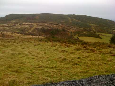
Picture: Such an innocent looking hill!
Barranisky is a small hill but it is difficult to reach the summit due to dense gorse and forestry growth. It is advisable to use a GPS to help track down the elusive trig pillar, although a few of us plucky MountainViewers have torn ourselves to shreds to bring the route to you!
Start at the forest entrance at BrNisky N (T25529 80221) which has space for 5 or 6 cars. Go up the track and take first right after 270m. Follow the track up hill. Eventually you will see the ruin of an old house at A (T25533 79336).Turn right here up a small track between the trees (be warned – don’t take the larger green road before this track as you will regret it!)
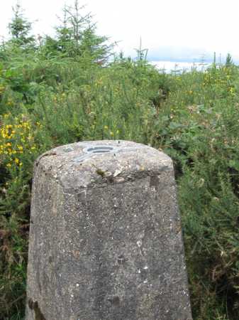
The track stops after 300m and then you must plunge into the impenetrable gorse to find the trig pillar only about 75 metres away. A faint trail may be present – but this will more likely be a whisper of where us previous pioneers have passed through, and may consist of nothing more than a slight disturbance of the gorse. The trig pillar is at the summit top as given in the grid reference for the summit above.
You could also turn off the main road at B (T243 790) and follow it past a number of houses until it comes to a dead end at a gate at BrNisky W (T249 791), with a sign saying “Private, Keep Out”. However Eircom have an agreed access track from the “Private No Entry” gate up through the farmland to their masts at the summit of Barranisky East. From here it is an easy ramble across to the ruin mentioned earlier.
Before you travel to find the elusive trig pillar!
by marrow-man
7 Jun 2011
Hi, just to begin I wasnt sure whether to put this comment under a summit rating or in the forum so apologies if its in the wrong place! I have nothing to say which hasnt already been said here about the awful route to the summit of Barranisky, but just a quick notice for anyone intending to reach the summit in the next few weeks(which probably isnt many people).
I went to climb Barranisky just before the bank holiday weekendand at the forestry car park entrance there was a Coillte notice saying they were investigating a possible disease outbreak in the forestry and asked that any walkers stay entirely on the forest paths (which means reaching the summit is impossible). There was a bucket of disinfectant for cleaning walking boots at the entrance so i assume it is quite a serious investigation. Anyone intending to climb the summit might want to ring Coillte in advance especially before travelling far. I will update this comment in the next few weeks when the sign is removed! Linkback: mountainviews.ie/summit/972/comment/6371/
Read Less
Read More
Picture: The all important proof shot.
Move along, absolutely nothing to see - part 2
by pn_runner
17 Mar 2011
I practically fell onto the trig point. The crawl space I'd been following stopped at a massive clump of gorze which masked the pillar. I was just starting to scan the ground for possible sites when it appeared in front of me.
In all I spent about 10 minutes in the final crawl in and out, nearly losing an eye in the process.
Many thanks to those who went before me, putting up the route making the nearly impossible just about possible. Linkback: mountainviews.ie/summit/972/comment/6275/
Read Less
Read More
Picture: Find this ruin on the right before attempting the summit.
The ruined house, essential waypoint.
by simon3
10 May 2010
View of the north side of Barranisky showing the ruined house near the least worst way to the summit. The north eastern summit (270m) with its telecoms towers is also obvious. Linkback: mountainviews.ie/summit/972/comment/4701/
Read Less
Read More
Picture: A dull looking Barranisky will test the mettle of hillwalkers!
wicklore on Barranisky
by wicklore
16 Nov 2008
Barranisky looks harmless enough as viewed from Barranisky East. Even though the top looks flat enough, there is a summit trig pillar buried in the dense growth. Should the main summit as a whole be named Barranisky East, as there is a seperate Barrinisky West? Linkback: mountainviews.ie/summit/972/comment/3442/
Read Less
Read More
Picture: The fabled trig pillar of Barranisky
Bring the machete.
by madfrankie
3 Aug 2010
Have you ever watched those old movies set in the Amazonian jungle, featuring the likes of Victor Mature or Charlton Heston hacking their way through dense undergrowth, and thought 'that looks like fun'? Well Barranisky is the hill for you.
I was determined to take the easiest route to the summit, so I followed Simon3's route as far as the old ruin at A (T25533 79336). However, there was another green road off to the right before the one mentioned, and so ensued 30 minutes of crawling on hands and knees through dense forestry. I eventually emerged, scratched and bedraggled onto the correct green road, and then spent another twenty minutes battering my way through 7ft high gorse to the summit.
The trig pillar, when it suddenly hoves into view, has something of the Raiders of the Lost Ark feel.. I would have been only mildly surprised to see a crystal skull set atop it.
A summit for the serious collector only. Or the masochist. Linkback: mountainviews.ie/summit/972/comment/5983/
Use of MountainViews is governed by conditions and a privacy policy.
Read general information about the site. Opinions in material here are not necessarily endorsed by MountainViews.
Hillwalking is a risk sport. Information in comments, walks, shared GPS tracks or about starting places may
not be accurate for example as regards safety or access permission. You are responsible for your safety and your permission to walk.
See the credits and list definitions.


 Add a Place Comment for Barranisky, Barr an Uisce


 Our Facebook page.