Cookies. This website uses cookies, which are small text files that the website puts on your device to facilitate operation. Cookies help us provide a better service to you. They are used to track general user traffic information and to help the website function properly.

Click to hide this notice for 30 days.
Welcome to MountainViews
If you want to use the website often please enrol (quick and free) at top right.
Overview
Detail
Zoom: ??
For more map options click on any overview map area or any detail map feature.
Find Suggested Walks
Find hill, mountain, island, coastal feature.
Videos


Recent Contributions
Get Notifications

Milane Hill: Not inviting but OK

Slievemore: Less prickly from North

Long trail to rewarding tops.

Knocknagree East Top: Fine top with good access mostly on trail

Steep ascent, stunning views

Very fine Carn with stunning views.

Mount Gabriel: Simple and stunning

Coomnalack Top: Lacks for nothing

GR 92: Estartit to l'Escala

Little Bin: Tough little climb

GR 92: Roses to Cadaques

Silvermines Hydro Project

Conditions and Info
Use of MountainViews is governed by conditions and a privacy policy.
Read general information about the site.
Opinions in material here are not necessarily endorsed by MountainViews.
Hillwalking is a risk sport. Information in comments, walks, shared GPS tracks or about starting places may not be accurate for example as regards safety or access permission. You are responsible for your safety and your permission to walk.
See the credits and list definitions.
Video display
Central Dingle Area   S: Annascaul Subarea
Place count in area: 25, OSI/LPS Maps: 70, 71, 78, EW-DC, EW-DE, EW-DW 
Highest place:
Beenoskee, 826m
Maximum height for area: 826 metres,     Maximum prominence for area: 491 metres,

Note: this list of places includes island features such as summits, but not islands as such.
Rating graphic.
Knocknanacree Hill Cnoc na nAcraí A name in Irish (Ir. Cnoc na nAcraí [OSI], 'hill of na hAcraí or the acres') Kerry County in Munster Province, in Binnion List, Aeolian sandstone Bedrock

Height: 286m OS 1:50k Mapsheet: 70 Grid Reference: V57213 99845
Place visited by 24 members. Recently by: Marykerry, chelman7, Deise-Man, Moses, mh400nt, conormcbandon, jgdarcy, JohnAshton, ucampbell, eamonoc, liz50, markmjcampion, frankmc04, omurchu, ciarraioch
I have visited this place: NO (You need to be a logged-in member to change this.)

Longitude: -10.086, Latitude: 52.132503 , Easting: 57213, Northing: 99845 Prominence: 260m,  Isolation: 4.7km,   Has trig pillar
ITM: 457194 599901,   GPS IDs, 6 char: Knc286, 10 char: Kncknncr
Bedrock type: Aeolian sandstone, (Kilmurry Sandstone Formation)

Acres (na hAcraí) is a townland name.   Knocknanacree is the 1190th highest place in Ireland. Knocknanacree is the second most southerly summit in the Central Dingle area.

Linkback: https://mountainviews.ie/summit/967/
COMMENTS for Knocknanacree (Cnoc na nAcraí) 1 of 1  
Follow this place's comments
Views to Slieve Mish and the Dingle Peninsula
Short Summary created by liz50  21 Mar 2017
Summit can be approached from the West by parking near Minard Castle V556 992 starA and following a rough track uphill past a quarry and onto the summit ridge.
A shorter steeper approach is possible from the road at Q57696 00630 starB
Further East at Q58394 00964 starC follow a track uphill to gain the ridge with a faint path to the summit cairn.
There are fine views over Inch beach and on a clear day over to the Blasket Islands Linkback: https://mountainviews.ie/summit/967/comment/5726/
 
MountainViews.ie Picture about mountain Knocknanacree (<i>Cnoc na nAcraí</i>) in area Central Dingle, Ireland
Picture: Slieve Mishs from the West
 
simon3 on Knocknanacree, 2009
by simon3  9 Jun 2009
Knocknacree is a short walk with a big payload on a good day. Take the smaller road SW out of Anascaul towards Minard, a ruined castle. You will find Knocknacree on your left, between you and the sea. In fact there is no road nearer the coast at this point. We stopped at Q57696 00630 starB where there was a widening in the road. Judging by the reactions of a sheep farmer who we met on our way back I don't think there's any great access problem around here. Essentially there is one layer of rough field between the road and the open hillside. The farmer we met owned one of these and was utterly uninterested in what we were doing there.

The climb up Knocknacree (known locally as Acres) is surprisingly difficult although short. It's at a steep gradient and has a sort of knee high dwarf furze growing on it. Don't wear shorts. Eventually you reach the ridge and can walk some 750m to the summit with great views on all sides on a good day.

It would also be possible to park nearer to the summit if you wanted to, and indeed there seemed a few places where there was both parking and easy access onto the wild hillside.

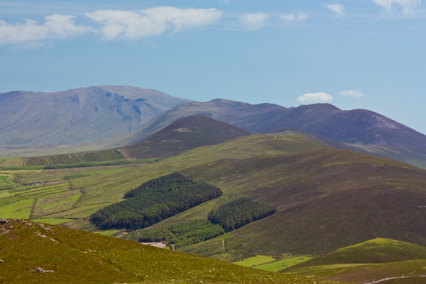
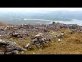
The summit has trig pillar. The picture shows the series of ridges gradually descending from the higher Slieve Mishs. Knocknacree is almost at the end of this series of ridges.

In the backround in the pic is Caherconree with Gearhane off to the left. On the right skyline is (starting from the furthest) the Knockbrack, Moanlaur, Knockmore ridge finishing at Emlagh the last bump on the right skyline. The darker rounded summit almost in the middle of the picture is Brickany. Linkback: https://mountainviews.ie/summit/967/comment/3837/
Your Score: Very useful <<  >>Average
 
MountainViews.ie Picture about mountain Knocknanacree (<i>Cnoc na nAcraí</i>) in area Central Dingle, Ireland
Picture: Lunch near the summit
Guinness powered ascent
by three5four0  29 Aug 2011
After another great night in Hanafins Bar in Annascaul, where we had more than several Guinness, it was decided to walk out from Annascaul again with Knocknanacree the objective for the day.

We followed the Dingle way along minor roads, towards, well Dingle Town. As the road starts to traverse the North side of Knocknanacree you come to a farm (on your right) with 2 tracks running up hill on your left. Take the second track at roughly 58394 00964 starC, go through the gate and walk up hill to another gate at the top of the field. Go through this and follow the track as it switch backs up the hill. Soon it will run along a fence, pick a suitable place to cross the fence (there is a couple of rocks placed so the long of leg can just step over) and gain the ridge, which a very faint path follows to the cairn. Continue on to the summit, just passed the summit is a small pen like structure (see the photo), where we stopped for lunch. Return was made by the way of ascent, as otherwise you end up in a lot of that furze which Simon mentions in his post. Linkback: https://mountainviews.ie/summit/967/comment/6495/
Your Score: Very useful <<  >>Average
 
MountainViews.ie Picture about mountain Knocknanacree (<i>Cnoc na nAcraí</i>) in area Central Dingle, Ireland
Picture: The hazy end of the Dingle Peninsula
 
simon3 on Knocknanacree, 2009
by simon3  9 Jun 2009
Looking south there's long view towards Mount Eagle (right skyline) while to the left of that is Croaghmore on the Great Blasket Island. On the horizon in the left half of the picture is Inishvickillane some 30k through the summer haze. Linkback: https://mountainviews.ie/summit/967/comment/3838/
Your Score: Very useful <<  >>Average
 
MountainViews.ie Picture about mountain Knocknanacree (<i>Cnoc na nAcraí</i>) in area Central Dingle, Ireland
Picture: Storm Beach and Cliffs at lower western reaches
Storm Beach and Cliffs at lower western reaches
by Bunsen7  17 Aug 2018
A view of "Acres" from Minard Beach. This is apparently a geologically interesting spot in itself as it is a storm beach comprised of large sandstone boulders. The castle is on private land and not closely accessible but Cromwell's forces gave it some strong blows many years ago, so getting too close might be inadvisable anyway.

Local signboards suggest an out and back from Minard Beach. The river and road directly to the east of this hill at Bunaneer would appear to prevent a route onwards to Knockafeehane. Linkback: https://mountainviews.ie/summit/967/comment/20024/
Your Score: Very useful <<  >>Average
 
(End of comment section for Knocknanacree (Cnoc na nAcraí).)

Main mapping:
Open Street Map
(Main supplier OpenTopoMap)
Height layer: © MapTiler
MapTiler Logo
British summit data courtesy:
Database of British & Irish Hills
(Creative Commons Licence)
MountainViews.ie, a Hill-walking Website for the island of Ireland. 2500 Summiteers, 1480 Contributors, maintainer of lists such as: Arderins, Vandeleur-Lynams, Highest Hundred, County Highpoints etc