Cookies. This website uses cookies, which are small text files that the website puts on your computer to facilitate operation. Cookies help us provide a better service to you. They are used to track general user traffic information and to help the website function properly.

Click to hide this notice for 30 days.
Welcome to MountainViews
If you want to use the website often please enrol (quick and free) at top right.
Overview
Detail
Zoom: ??
For more map options click on any overview map area or any detail map feature.
Detail Map Features
Find Suggested Walks
Find hill, mountain, island, coastal feature.
Videos


Recent Contributions
Get Notifications

Met Eireann launches 10-day mountain forecast

A very tough outing in Glen Etive

Knockalla: Anticlockwise loop walk.

Bloody Foreland: Easy going walk.

Tonduff: Some nice views, but unexciting summit

Windfarm eases access

Slieve Carn: Working Bog and Wind Farm

Carranarah: Electric Dreams

Access via rocky trail

Bockagh Hill: Short but Hard Bag.

Minneapolis: Minnihaha creek walk

Mullaghanoe: Forest harvesting and mast compound

Conditions and Info
Use of MountainViews is governed by conditions and a privacy policy.
Read general information about the site.
Opinions in material here are not necessarily endorsed by MountainViews.
Hillwalking is a risk sport. Information in comments, walks, shared GPS tracks or about starting places may not be accurate for example as regards safety or access permission. You are responsible for your safety and your permission to walk.
See the credits and list definitions.
Video display
Achill & Corraun Area   S: Knockmore Achill Subarea
Place count in area: 16, OSI/LPS Maps: 22, 30, CBW, EW-ACC, EW-ACC 
Highest place:
Croaghaun, 688m
Maximum height for area: 688 metres,     Maximum prominence for area: 688 metres,

Note: this list of places includes island features such as summits, but not islands as such.
Rating graphic.
Tievereivagh Hill Achill Island Island Taobh Riabhach A name in Irish, also Deereens Hill an extra EastWest name in English (prob. Ir. Taobh Riabhach [PDT], 'grey or striped (hill-)side') Mayo County in Connacht Province, in Binnion List, Pale quartzites, psammitic schists Bedrock

Reachable "On Foot " Y
Height: 286m OS 1:50k Mapsheet: 30 Grid Reference: L71000 95800
Place visited by 22 members. Recently by: poopoobasto, elizauna, ryanguinness10, annem, ppatten, FrankMc1964, moggy40, Wilderness, Fergalh, David-Guenot, markmjcampion, Oileanach, Garmin, chalky, garrettd
Island visited by 525 members.
I have visited this place: NO (You need to be a logged-in member to change this.)   I have visited Achill Island: NO (You need to be a logged-in member to change this.)

Longitude: -9.963084, Latitude: 53.895637 , Easting: 71000, Northing: 295800 Prominence: 250m,  Isolation: 3.1km
ITM: 470978 795812,   GPS IDs, 6 char: Tvrvgh, 10 char: Tvrvgh
Bedrock type: Pale quartzites, psammitic schists, (Corraun Quartzite Member)

This peak is unnamed on OS maps. On William Bald's map of Co. Mayo (1830) the name Tievereivagh appears on the W slopes. Whilst it is not certain that this this is the name of the hill as a whole, as opposed to a particular flank, it appears to be the only name available for this peak. For a walk around the base of Tievereivagh, see Siúlóidí Acla, walk L. Previously Derreen in MV.   Tievereivagh is the 1190th highest place in Ireland.

Linkback: https://mountainviews.ie/summit/966/
COMMENTS for Tievereivagh (Taobh Riabhach) 1 of 1  
Follow this place's comments
three5four0 on Tievereivagh, 2009
by three5four0  15 Apr 2009
Park opposite the cemetery at 718971 starA (enough room for several cars) and take the minor road at 717971 starB (Breanaskil). Follow this road up hill till 711968 starC, where you turn left onto a hill track. After a short distance this track forks and from here you can either head straight up hill or follow the right hand fork to take in pt 230 before Derreens' summit.

The views are superb from the small summit, which has several rock out crops with glorious twisted strata on show. We had picked this hill for what should have been a bad day weather wise but turned out otherwise. Short enough to be walked on a summers evening after dinner or grabbed between showers, recommended for the views.

You can return the same way as your ascent or, descend steeply through some benched peat, to a track south east from the summit. There is a messy area where stone is being extracted, but after that you can follow the old track round & above a series of deserted ruined cottages, slowly descending towards Achill Sound. You may be able to follow this track right round the hill & after a short section across open hillside, rejoin your route of ascent. We descended to the road via one of the lane ways that accessed the track, from where it was just over a 1 km back to the car, with a short stop off at the pub beside the PO for a nice pint of Guinness. Linkback: https://mountainviews.ie/summit/966/comment/3718/
Your Score: Very useful <<  >>Average
 
MountainViews.ie Picture about mountain Tievereivagh (<i>Taobh Riabhach</i>) in area Achill & Corraun, Ireland
Picture: Pt 263 on Tievereivagh
 
A small hill of distinction.
by Harry Goodman  9 Jul 2011
As one of two remaining hills that I had not climbed I took the opportunity to do so on Mon 20 June 2011. We left the car in a small parking area on the Atlantic Drive road around the southern tip of Achill, opposite a graveyard L7180097100and walked back a short distance to a narrow road leading off to the left L7175097100 starD. We followed this along for about 500 metres to
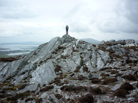
 L7110096800 starC to a track marked on the OSI Map 30. A locked gate is now in place across the entrance and the site is being prepared for building a house(s). Signs are in place pointing out that there should be no trespassing and advising of the need for parental responsibility to ensure children are kept out. After some discussion, as no actual construction had commenced, we decided to climb over and use the lane to access the hill. Once out on to the open hillside we climbed up SSE to Pt. 263 which turned out to be a fine rocky promontory, L7100095800 starE well worth the climb and indeed much more dramatic and imposing than the high point of the hill some 300 metres further to the SW across a patch of quite extensive old peat cuttings. Once at the top
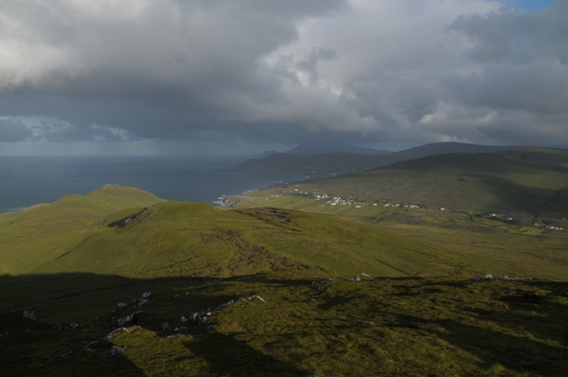
 L7100095800 starE and having admired the views across Clew Bay, past Clare Island, to Croagh Patrick, the Sheefrey,s and Mweelrea we descended more or less due N past some large rocky crags and down to our starting point. We were up and down easily within an hour and a half. This is a small hill but one of distinction compared with some more than twice it's size, especially if one takes the time to include Pt. 263 on the way up (or down). However, in view of the building site which is now "blocking" the lane that was been used by us and by others to access the hill an alternative access point may be advisable. In this regard I note that another track is shown on the map at L7205097200 starF which appears to give access to the open hillside and would be worth considering provided it too has not become a site for building. The same car park point could be used. Linkback: https://mountainviews.ie/summit/966/comment/6402/
Your Score: Very useful <<  >>Average
 
MountainViews.ie Picture about mountain Tievereivagh (<i>Taobh Riabhach</i>) in area Achill & Corraun, Ireland
Picture: View from Dereens to Croughaun
Early morning Achill
by eamonoc  14 Aug 2013
12/8/2013, 7am Went to the cemetary as mentioned by three5four0, then drove up to point 711968 starC. There is room here for one or two cars. I parked opposite a private house beside the obvious hill track, I followed this for a short distance and then headed up open hill side and reached the summit in 32 mins. Lingered for a while to enjoy views over Achill Sound and north towards Croaghaun. Linkback: https://mountainviews.ie/summit/966/comment/15068/
Your Score: Very useful <<  >>Average
 
Use the trail for access to the mountain
by moggy40  12 Aug 2019
Park at Pattens Pub and follow the Sli Grainne Mhaol (clockwise) to the high point on the trail, from there a short sharp climb to the summit can be made, I would recommend descent by the same way and continue to finish the trail back to Pattens for refreshments. Magnificent views of Achill and the Mayo/Galway mountains from the summit Linkback: https://mountainviews.ie/summit/966/comment/20621/
Your Score: Very useful <<  >>Average
 
(End of comment section for Tievereivagh (Taobh Riabhach).)

OSi logo OSNI/LPS logo
Some mapping:
Open Street Map
(Various variations used.)
British summit data courtesy:
Database of British & Irish Hills
(Creative Commons Licence)
MountainViews.ie, a Hill-walking Website for the island of Ireland. 2300 Summiteers, 1460 Contributors, Newsletter since 2007