Cookies.
This website uses cookies, which are small text files that the website puts on your device to facilitate operation. Cookies help us provide a better service to you. They are used to track general user traffic information and to help the website function properly.
Features
Nearby features appear when you click the map.
Declutter tracks on map.
Place Search
Video
X
Pub: by
Belfast Hills Area , N: Belfast Hills North Subarea
Feature count in area: 9, by county: Down: 5, Antrim: 4, OSI/LPS Maps: 15, 20, 21
Highest Place: Divis 478m

Starting Places (2) in area Belfast Hills:
Ballyherly Lough West, Castlemahon Mountain South East

Summits & other features in area Belfast Hills:
E: Belfast Hills East: Cairngaver 217m, Ouley Hill 186m, Scrabo Hill 160m
N: Belfast Hills North: Carnmoney Hill 231.1m, Cave Hill 368m, Divis 478m, Slievetrue 312m
SE: Strangford & Portaferry: Ballywhite Hill 101m, Castlemahon Mountain 128m

Note: this list of places may include island features such as summits, but not islands as such.
Rating graphic.
Slievetrue, 312m Hill Sliabh an Triúir A name in Irish,
Place Rating ..
(Ir. Sliabh an Triúir [AMacAB], 'mountain of the three (brothers)'), Antrim County in Ulster province, in Binnion Lists, Slievetrue is the third highest hill in the Belfast Hills area and the 1134th highest in Ireland. Slievetrue is the most northerly summit in the Belfast Hills area.
Grid Reference J34666 89120, OS 1:50k mapsheet 15
Place visited by: 36 members, recently by: ElaineM76, Carolyn105, Jai-mckinney, Oscar-mckinney, trostanite, Andy1287, Fergalh, eamonoc, jimbloomer, LorraineG60, MichaelG55, eflanaga, Wilderness, Ulsterpooka, jimmyread
I visited this place: NO (You need to be a logged-in member for this.)
Longitude: -5.910279, Latitude: 54.732014, Easting: 334666, Northing: 389120, Prominence: 189m,  Isolation: 6.2km, Has trig pillar
ITM: 734585 889111
Bedrock type: Olivine basalt lava, (Upper Basalt Formation)
Notes on name: Marked as Carn Hill on the OSNI Discoverer map, but better known as Slievetrue. Locally this is pronounced Slieveytrue with 3 syllables. The mountain derives its Irish name from 3 standing stones known as The Three Brothers, located about half a mile SW of the summit. These are now somewhat disguised as they have been integrated into a field wall.
  Short or GPS IDs, 6 char: Slvtr, 10 char: Slievetrue

Linkback: https://mountainviews.ie/summit/945/
Gallery for Slievetrue (Sliabh an Triúir) and surrounds
No summary yet for this place .
Member Comments for Slievetrue (Sliabh an Triúir)
Comment create / edit display placeholder

            MountainViews.ie picture about Slievetrue (<em>Sliabh an Triúir</em>)
Picture: Looking N over wooded Carninard to Agnew's Hill from the top of Slievetrue
Harry Goodman on Slievetrue
by Harry Goodman 30 Aug 2009
As this is one of the 100 hills nearest to where I live I decided to combine a climb over it with a walk in Woodburn Forest. I parked at one of the entrance tracks into the forest ( A (J352 887) ) which served as the start point for both walks. For Slievetrue walk some 50 metres S along the road and turn right up a farm track, which also serves as access to the communications ariel near the top. On my way up I spoke to a lady at the first house and asked if it was permissible for me to use the lane to get to the top of the hill. She told me that there was no problem. On the way up I passed through a number of gates. The top is marked by a trig pillar at 312m. From here the 360 degree view is splendid (even with the mast ). To the N is Agnew's Hill and the the hills forming the eastern escarpment of the Antrim Plateau (see picture). W are the Sperrins and Lough Neagh. In the foreground SW is the main ridge of the Belfast Hills from Divis to Cave Hill while S is the outline of the High Mournes from Donard to Eagle Mountain. The view E is across Carrickferfus to Belfast Lough and the Copeland Islands Once I had taken my fill of this wonderful panorama I decided to go in search of "The Three Brothers", standing stones mentioned in the main write up to Slievetrue. Initially I headed SW over the flatish top of the hill then down a small dip to a fence junction, which I crossed, and the up a small rise to a fence which I followed down to the right to meet a small cement lane. The standing stones are at the meeting point with the lane. As mentioned in the main write up, they are to some extent built into the field wall (B (J338 888)). All said they are not very impressive! I then retraced back to Slievetrue before taking a direct line E with a touch of S down the hillside to a ruined farm (C (J350 890)) to pick up a cement path leading out to the road where a right turn and 200 metres brought me back to the start. If in the area this little hill is worth climbing for the views but I would suggest that you do not go out of your way to do so. Straight up and down could be done in 30 minutes. By the way from the top you can see the two other listed hills for Belfast, Divis to the SW and E across Belfast Lough Cairngaver the higest point in the Craigantlet Hills. Linkback: mountainviews.ie/summit/945/comment/4062/
Read Less
Read More

            MountainViews.ie picture about Slievetrue (<em>Sliabh an Triúir</em>)
Picture: slievetrue across woodburn upper resevoir
gerrym on Slievetrue
by gerrym 20 Oct 2009
A cracking walk around three resevoirs to a high point with great views over a wide area. Start at 
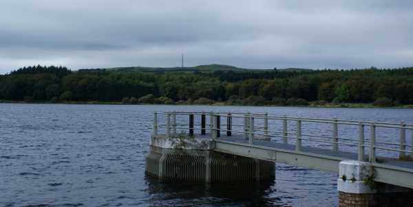
D (J377 894) in carpark favoured by anglers. A couple of minutes brings the grass rampart of the first of three resevoirs - a peaceful scene with all ages comfortably fishing and BBQ smoke drifting lazily. Views already reach to Belfast Lough, the towers of Ballylumford power station and over to the Scottish coast.

Track around the S end of the resevoir through mature pine trees to the next grass rampart and follow service road to yet another rampart of the third resevoir. The resevoirs sit at progressively higher levels and thier high dams are visible ahead, wonder building at what lies beyond each time. Fittingly they get more impressive in scale and setting with each rise. Again follow the S side of the resevoir on open ground, then pine and beech trees. A little stream drops down just before the head of the resevoir - follow this uphill through forest and then rough grass to join a forest track - follow this to the right, take next right turn, then left which brings a road at A (J352 887).

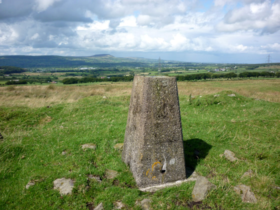
From here follow the directions given by Harry Goodman. I had some trepidation at being on others property. Thi swas misplaced as i think i met the same lady - who was helping to "dose cows" and had a particulary handy looking length of blue water pipe in her hand. She graciously directed me towards the top through two gates, past the mast and on the site of an old cairn. The views are really impressive - particulary across the line of the Belfast Hills to the Mournes, contrasting with the modernity of docks, cranes and high rise buildings. Reached in 3.5 miles and 1hour 20 minutes. Took my time to savour the views (along with my tea and lunch), thanking those about on the return.

Returned along the paths on the northern side of the resevoirs to complete a circuit of all three, passing other walkers, runners, cyclists, anglers and horse riders. The weather had cleared and the waters were reflecting bright sunshine and it was just a good place to be. In all 7 miles and 2.5 hours - not at all taxing, more relaxing. Linkback: mountainviews.ie/summit/945/comment/4219/
Read Less
Read More

Changes?
by Peter Walker 16 Feb 2012
The wise man isn't late home on Valentine's Day, and so it was that I went for the same route up and down Slievetrue as used by Harry Goodman and gerrym, but without any additional exploration. Nobody was in evidence on the way past the house on the way up so I pressed on to the top, and was greeted by a northerly Antrim vista smothered by a dampened blanket of grey cloud, and to the south Cave Hill was fighting a losing battle to prevent Belfast from being similarly inundated.

With all that said I must alert other Mountainviewers to a possible change to access to Slievetrue. On my descent I met a group of people just above the house and I thought it sensible and proper to tell them where I’d been and to check that access was still in place. I was politely-but-firmly told that access to the top required the permission of the Police Authority and that without it I would have to return to the road. Worth bearing in mind if you’re contemplating an ascent. Linkback: mountainviews.ie/summit/945/comment/6689/
Read Less
Read More
EDIT Point of Interest
text
Videos


Recent Contributions
x
Conditions and Info
Use of MountainViews is governed by conditions and a privacy policy.
Read general information about the site.
Opinions in material here are not necessarily endorsed by MountainViews.
Hillwalking is a risk sport. Information in comments, walks, shared GPS tracks or about starting places may not be accurate for example as regards safety or access permission. You are responsible for your safety and your permission to walk.
See the credits and list definitions.

OSi logo
OSNI/LPS logo
Open Street Map
(Various variations used.)
British summit data courtesy:
Database of British & Irish Hills