This website uses cookies, which are small text files that the website puts on your device to facilitate operation. Cookies help us provide a better service to you. They are used to track general user traffic information and to help the website function properly.
Feature count in area: 62, by county: Cork: 45, Kerry: 24, of which 7 are in both Cork and Kerry,
OSI/LPS Maps: 78, 79, 85, 86, 88, 89
Highest Place: Knockboy 704.8m
Starting Places (47) in area West Cork Mountains: Barley Lake North, Barrboy, Caha Pass, Carranmore, Carrigacappeen, Carriganass Castle, Castle Donovan Car Park, Clearagh House, Coolkellure House, Coomhola Bridge, Corrigatirra, Cousane Gap, Cummer Lough East Road, Derreencollig Wood, Esk Boreen, Fuhiry Wood, Garinish Island Pier, Glasagarav River Bridge, Glasnacummeen Stream, Glengarriff, Glengarriff Nature Reserve CP, Gorteeniher Drimoleague Heritage Walk CP, Gortloughra River Road, Gougane Barra Oratory, Gougane Barra Park CP, Grousemount Wind Farm, Kealkill Village, Knockanuha, Knockbrack South, Lough Atooreen N, Lough Nambrackderg North, Lough Nambrackderg Wood, Lough Nambreacdearg, Mealagh Bridge, Molly Gallivan's Visitor Centre, Nowen Hill West Road, Owvane River Bridge, Pookeen North Top Road, Pooleen Wood Car Park, Priests Leap, Reenroe Bridge, River Roughty, Shandrum Concrete Silo, Sillahertane Stream, Slaheny River Horseshoe, Top of Coom, Turner's Rock Tunnel
Summits & other features in area West Cork Mountains: Cen: Maughanaclea: Maughanaclea Hills East Top 470m, Maughanaclea Hills West Top 452m Cen: Shehy More: Shehy More 545.6m, Shehy More SW Top 446m E: Clearagh: Clearagh Hill 287m E: Currane: Currane Hill 228m N Cen: Douce: Douce Mountain 476m, Doughill Mountain 471m N: Carran: Barnastooka 497m, Bealick 537m, Carran 604m, Carran Far NE Top 561m, Carran Far North Top 506m, Carran NE Top 555m, Carran South Top 567m, Knockantooreen 450m N: Conigar: Conigar 566m, Conigar SW Top 566m, Foilastookeen 540m N: Coomataggart: Carrigalougha 423m, Coomataggart 530m, Coomataggart SW Top 509m, Derrineanig 304m, Lackabaun 472m, Mweelin 487m NE Cen: Carrigarierk: Carrigarierk 343m NW: Barraboy: Barraboy Mountain 460m, Barraboy Mountain Far East Top 456m, Barraboy Mountain SE Top 409m, Derroograne 468m, Turners Rock 420m NW: Knockboy: Caoinkeen 692.8m, Caoinkeen South-East Top 553.5m, Coomhola Mountain 472m, Knockboy 704.8m, Knockboy North Top 651.2m, Knockboy South Top 533.3m, The Priest's Leap 519m NW: Knocknamanagh: Bird Hill 412m, Coomclogherane Top 449m, Gullaba Hill 603m, Knockbrack 440m, Knockbrack South Top 458m, Knocknamanagh 637m, Knocknamanagh NE Top 625m S Cen: Dunmanway Hills: Cashloura 296.8m, Coolsnaghtig 295.8m, Inchanadreen 310m S Cen: Nowen: Milane Hill 354.4m, Mullaghmesha 494.3m, Nowen Hill 535.2m, Nowen Hill Far West Top 405.2m, Nowen Hill SW Top 509m, Pookeen North Top 319m S: Leap Hills: Carrigfadda 311.7m, Killeigh Hill 229m, Knockarudane Hill 169m, Knockscagh 195m S: Skibbereen: Barryroe Hill 156m, Lick Hill 158m W Cen: Knockbreteen: Knockbreteen 239m W: Bantry: Knocknaveagh 282m
Note: this list of places may include island features such as summits, but not
islands as such.
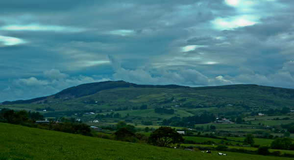
Carrigfadda, 311.7mHill An Charraig Fhada A name in Irish,
Place Rating ..
(Ir. An Charraig Fhada [logainm.ie], 'the long rock'), Cork County in Munster province, in Binnion Lists, Carrigfadda is the 1138th highest place in Ireland.
Grid Reference W24242 43066,
OS 1:50k mapsheet 86,89 Place visited by: 39members, recently by: jackos, Petecal423, Leatra, DeirdreM, Kirsty, nickywood, JohnRea, chelman7, ciarraioch, learykid, conorb, Fergalh, Daingean, sophpow, CaminoPat
I visited this place: NO (You need to be a logged-in member for this.)
Short or GPS IDs, 6 char: Crgfd, 10 char: Carigfada Linkback: https://mountainviews.ie/summit/943/
Gallery for Carrigfadda (An Charraig Fhada) and surrounds
Summary
for Carrigfadda (An Charraig Fhada):
A well maintained community track
Summary created by jackill
2012-08-03 09:02:06
Picture: Carrigfadda from the east
Park at A (W24508 42835) a large carpark with room for 10 cars.Follow the grassy steps leading steeply uphill and then a dirt track all the way to the cross and the actual summit 150 meters to the east. Continue east and downhill taking the next fork left to return by your orginal ascent route.
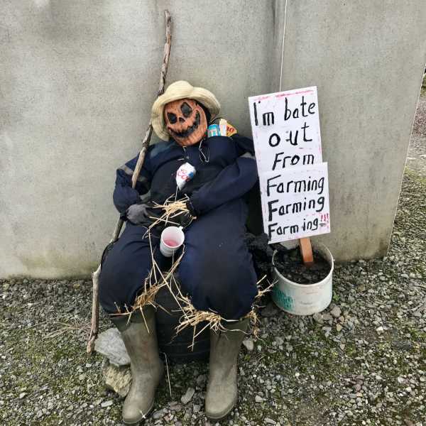
Picture: Local Farmers getting into the Samhain spirit
Climbed An Sticín during Halloween instead of Christmas Day
by conorb
10 Nov 2022
After parking at the church, I took the bóithrín up past the farmyard to the base of the woodland which was clearcut a couple of years ago. Then it was a climb up to An Sticín as it is know locally.
At one time it was a popular place for locals on Christmas Day as recorded in the Schools Collection.
"The highest point of Carrigfadtha hill - a few miles due south of Drinagh is called the Sticín. From this hill a great view is obtained of the southern sea board, from Roaring water to Bantry Clonakilty Bay. People from all parts assemble here on Christmas day and indulge in stone throwing and leaping. It seems strange that this day should be selected for such a cold exposed place at this time of year with poor visibility. Some old residents think that the custom has come down from Penal days when Mass on the Mountain was celebrated and of course Christmas Day would attract an immense number of people to the spot at such a time. If not disturbed by military there would be a tendency to diversion after Mass and the usual games of strength and skill would be indulged in between the champions of the different parishes." Linkback: mountainviews.ie/summit/943/comment/23749/
Read Less
Read More
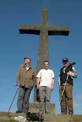
Picture: Fachtna O'Callaghan, Noel Fitzpatrick & Teddy Coakley on the summit of Carrigfadda
calvin141170 on Carrigfadda
by calvin141170
29 Sep 2008
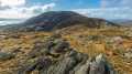
A new public walkway is nearing completion on Carrigfadda. The initial climb is a bit on the steep side, but steps are being put in place to make the walkway more accessible to young and old. It's only a short walk, but the panoramic view of the West Cork coastline -- from the Old Head of Kinsale right around to the Mizen and Beara peninsulas -- is nothing short of spectacular.
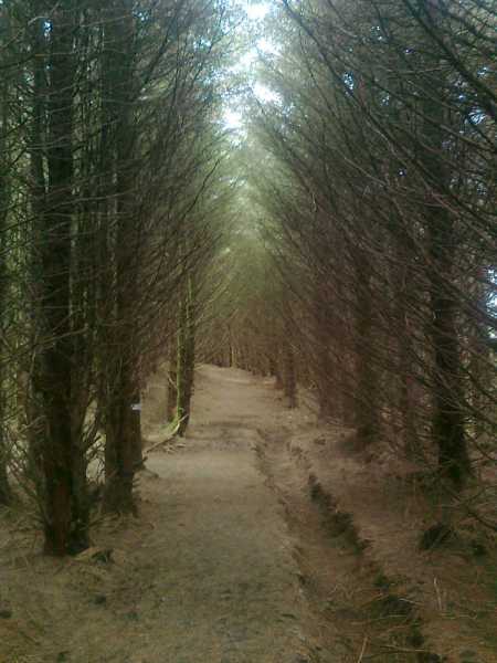
Picture: Watch out for a white marker tacked to a tree
Loop walk to the top of the hill
by acorn
7 May 2013
Carrigfadda Loop Walk on www.irishtrails.ie is perfect for visiting this little top.
Travelling from Skibbereen to Clonakilty on the N71 turn left at a sharp bend just before the bridge in Connonagh. Follow this road to Carrigfadda Church GR B (W24508 42848) where there is ample parking and a mapboard. The route of the loop walk takes you briefly back the road you came before turning right onto a minor road which leads to a forestry entrance at the base of the hill. A steep ascent brings you to the cross from where you can see the trig point further along the ridge. After the trig point the track enters the forestry. Shortly after entering the forest you take a left. The loop walk marker seems to be missing at this point so keep an eye out for a white corrugated card marker tacked to a tree indicating the way. The entire loop takes no more than an hour. Linkback: mountainviews.ie/summit/943/comment/14988/
Read Less
Read More
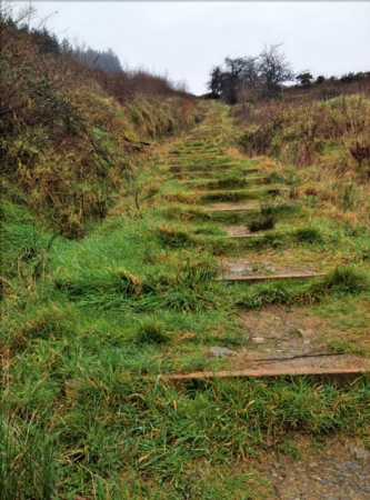
Picture: Stepped ascent to summit
Short and sweet
by thomas_g
10 Feb 2012
Two options for parking here, at the base of the hill at A (W24508 42835) or at Carrigfadda Church at B (W24508 42848) which adds an extra 2km along the road.
If you choose to start at the hill, I suggest you climb up the forest road beyond the car park to give your legs a chance to warm up, keep right on the road and you'll end up halfway up the steps: which are steep and can be slippery if wet.
You'll easily be up and down in an hour with plenty of time at the top for the views (fog today), the trig point for the summit is beyond the cross (assuming you stay right after climbing the steps). Linkback: mountainviews.ie/summit/943/comment/6678/
Use of MountainViews is governed by conditions and a privacy policy.
Read general information about the site. Opinions in material here are not necessarily endorsed by MountainViews.
Hillwalking is a risk sport. Information in comments, walks, shared GPS tracks or about starting places may
not be accurate for example as regards safety or access permission. You are responsible for your safety and your permission to walk.
See the credits and list definitions.


 Our Facebook page.