This website uses cookies, which are small text files that the website puts on your device to facilitate operation. Cookies help us provide a better service to you. They are used to track general user traffic information and to help the website function properly.
Feature count in area: 27, all in Antrim,
OSI/LPS Maps: 14, 15, 4, 5, 8, 9
Highest Place: Trostan 550m
Starting Places (3) in area Antrim Hills: Donalds Carn, Rathlin Island Ferry Port, Whitehead Golf Club
Summits & other features in area Antrim Hills: Cen: Central Antrim Hills: Carncormick 436m, Collin Top 429m, Crockalough 402m, Mid Hill 440m, Skerry Hill 459m, Slieveanorra 508m, Slievenahanaghan 418m, Soarns Hill 403m, Tievebulliagh 402m, Trostan 550m Central Antrim Hills: Slievenanee 543m N: North Antrim Hills: Carnanmore 379m, Croaghan 417m, Crockaneel 403m, Cross Slieve 206m, Knocklayd 514m, Lannimore Hill 207m N: Rathlin Island: Kilpatrick (Rathlin Island) 134m S: Islandmagee: Donalds Carn 141m, Muldersleigh Hill 131m S: South Antrim Hills: Agnew's Hill 474m, Big Collin 353m, Black Hill 381m, Carnearny 319m, Douglas Top 402m, Slemish 437.9m W: West Antrim: Long Mountain 215m
Note: this list of places may include island features such as summits, but not
islands as such.
Carnearny, 319mHill Carn Éireann A name in Irish,
Place Rating ..
(Ir. Carn Éireann [DUPN], 'Ériu's cairn'), Antrim County in Ulster province, in Binnion Lists, Carnearny is the 1115th highest place in Ireland. Carnearny is the most southerly summit in the Antrim Hills area.
Grid Reference J17644 92707,
OS 1:50k mapsheet 14 Place visited by: 48members, recently by: ElaineM76, conormcbandon, Paddym99, garybuz, Carolyn105, Claybird007, eflanaga, Kilcoobin, Andy1287, Rabsoffagain, trostanite, Hoverla, eamonoc, Fergalh, LorraineG60
I visited this place: NO (You need to be a logged-in member for this.)
Longitude: -6.173488, Latitude: 54.768474, Easting: 317644, Northing: 392707,
Prominence: 150m, Isolation: 6.9km ITM: 717530 892695 Bedrock type: Olivine basalt lava, (Upper Basalt Formation) Notes on name: The hill derives its name from a cairn at the summit. Ériu is a sovereignty goddess embodying Ireland. Éire is the Modern Irish form of this name. See Arderin in Slieve Bloom, which has a similar origin. Unfortunately, the cairn is overgrown and the formerly excellent view of Lough Neagh has been totally blocked by newly planted conifers. Tobernaveen Hill is a slightly lower hill to the west. Carnearny is recorded in the Annals of the Four Masters as the site of a battle in 912 AD where the local chieftain Loingsech Ua Lethlobhair (Lawlor) was defeated by Niall, son of Aedh Finnliath of Tyrone [LNP].
Short or GPS IDs, 6 char: Crnrny, 10 char: Carnearny Linkback: https://mountainviews.ie/summit/933/
Gallery for Carnearny (Carn Éireann) and surrounds
Summary
for Carnearny (Carn Éireann):
Another case of bring the gaitors
Summary created by simon3, wicklore
2015-02-16 08:42:12
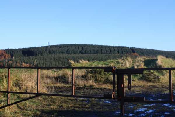
Picture: Carnearney Hill
Carnearney is a forest covered hill that only affords views on the approach roads or from one area of cleared forestry on its western slopes. It is popular with mountain bikers and scramblers, so the trails through the trees are churned up and very muddy in places. By parking at the forestry entrance at A (J176 923), you can ramble along the forest track to a telecommunications mast, from where the small summit clearing is a short uphill hop. Alternatively from the forest entrance you can head directly to the summit through the trees in about 10 minutes, where you will soon join a churned up trail leading to the summit trig pillar which is obscured amongst vegetation.
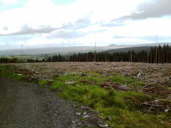
Picture: Looking towards Slemish from the slopes of Carnearny
slemish on Carnearny
by slemish
8 Oct 2009
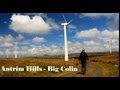
Despite being one of the closest hills to where I live, I had never climbed Carnearny before. It doesn't look particularly exciting from afar with its wooded summit only 319m high, but I found climbing it an enjoyable experience. I parked at the entrance to the forest (A (J176 923)) and followed the track all the way round to the northern side of the hill. A vast area has recently been felled on this side which opens up a fantastic view. A line of 400m+ summits extends from the wind farm on Slievenahanaghan through
Skerry Hill, Slievenanee, Trostan, Carncormick, Slemish and Douglas Top. To the east, another wind farm - this one on Big Collin and beyond that Agnew's Hill. I walked down a short path which opened up another view to the west and the Sperrins, the distant peaks of Sawel and Dart were shimmering in the autumn sunshine. Turning round, I headed up past the huge mast towards the summit area. Unfortunately some quad bikes have badly churned up the path to the summit which didn't help considering I was wearing trainers. The path winds its way upwards through very dense tree cover. I was beginning to lose hope of discovering the trig pillar when suddenly I emerged into a little clearing and there it was. Perhaps Antrim's least conspicuous trig pillar? Even the vegetation in the clearing now obscure the pillar itself, never mind the trees. Maybe the protection afforded would explain why the flush bracket and spider were in such good condition. Soon enough I headed back to the car by retracing my steps, an excellent way to spend an hour or two on an October afternoon. Linkback: mountainviews.ie/summit/933/comment/4193/
Read Less
Read More
Picture: Mr Trig pillar
gerrym on Carnearny
by gerrym
6 Oct 2008
In rating Carnearny my scores did not lift it above the lowly 21%. Today to me it is not a place that is a great challenge, has wonderful views or is a wild and lonely place - but go back to my childhood and it is a very different story.
Living in Antrim on the shores of Lough Neagh, Carnearny rose to what seemed to be unimaginable heights and was often dusted with snow when we were soaked by rain. Many a Sunday was spent walking with family and pets through the wooded slopes. With age and independence i visited on my own to walk, cycle and run - as i still do today. At a time the wooded summit was clear and views abounded - to the Sperrins, the Mournes, Belfast hills and the whole of Lough Neagh - now it is glimpses here and there. To be there was like being on top of the world, everything was a marvel - a trig pillar! a communications mast! fire dams! looking into the big quarry!
The tracks through the forest will provide an hour of exercise and can easily be linked with nearby Tardree Mountain to prolong the experience. It doesn't grab my heart now in the way the cliffs of Slieve League or other big dramatic hills do but it does have a special place there and always will do - it is where i started walking in and wondering at the marvel of the hills in Ireland. Linkback: mountainviews.ie/summit/933/comment/3360/
Read Less
Read More
mattc on Carnearny
by mattc
19 Jan 2009
to be perfectly honest - I think this view is near to perfection. 9 out of ten for me. It combines forestry with mountains, lowland, lough neagh and even 4 counties can be seen from here. Although it is not well known it will always stick in my mind. Linkback: mountainviews.ie/summit/933/comment/3532/
Read Less
Read More
Picture: Where Bonar practised his art?
From Carnearney to Hyde Park
by wicklore
15 Nov 2010
Carnearny’s summit once boasted fine views across Lough Neagh and to the Mountains of Mourne and the Sperrins. Those views would need to be sought on the approach to the hill, as the summit itself is now mostly covered in forestry. As well as smothering the views, the forestry provides excitement to quad bikers, scramblers and mountain bikers who have churned up the trails leading to the summit. However there is an area on its western slope where forest clearance allows views out to the west. By parking at the forestry entrance at 17692, you can ramble along forest tracks to the cleared area to the west. A track leads past a telecommunications mast to the small summit clearing, where a trig pillar sits amongst the vegetation. Alternatively from the forest entrance you can head directly to the summit through the trees where you will soon join a churned up trail to the summit. The return trip could be as little as 30 minutes, with little to promote a longer stay unless you ramble along the forest tracks. For those travelling from further afield, Carnearney can easily be included in a spate of individual hill climbs in Antrim.
As an interesting aside, the well known Hyde Park Speakers Corner orator, Bonar Thompson, who held forth from 1920-1960, was born in the area of Carnearny. Perhaps he practiced his craft on these slopes? The book about the story of his life ‘Bonar Thompson, the Old Days of Carnearney’ may contain useful tidbits about this low, forest covered hill. One of Bonar Thompson’s quotes could be applied to our sport of climbing the hills and mountains of Ireland – ‘he who tries can fail. But he who doesn't try, already has’. Linkback: mountainviews.ie/summit/933/comment/6162/
Read Less
Read More
three5four0 on Carnearny
by three5four0
2 Oct 2008
Climbed, if that is the right word for an ascent on forestry tracks, to Carnearny's summit the same day i climbed Slemish, Douglas top, Big Collin & Divis. There is no view from the summit, the trees are to mature now for that now, the track had also been churned up by trail bikes, so not advisable in your new trainers! Also the parking place marked on the map appears to be blocked now, there is however space for 2 cars at A (J176 923), which is also the access point for the forest. Follow this track, tack the first right after 450 metres, and right again after another 100 metres, where this track ends on the map (B (J177 925)) a churned up track goes left & climbs up to the summit trig point (not marked on the current map). Best combined with several other hills to give a full day out. Linkback: mountainviews.ie/summit/933/comment/3349/
Use of MountainViews is governed by conditions and a privacy policy.
Read general information about the site. Opinions in material here are not necessarily endorsed by MountainViews.
Hillwalking is a risk sport. Information in comments, walks, shared GPS tracks or about starting places may
not be accurate for example as regards safety or access permission. You are responsible for your safety and your permission to walk.
See the credits and list definitions.


 Our Facebook page.