Donation Request 2024

DONATE
Members and Supporters, the MountainViews Committee requests your help to meet the costs of the website and of other activities such as insured events or publications.
You do not have to be logged in to donate.
Features
Nearby features appear when you click the map.
Declutter tracks on map.
Place Search
Video
X
Pub: by
West Clare Area , NE: Burren East Subarea
Feature count in area: 14, all in Clare, OSI/LPS Maps: 51, 52, 57, 58
Highest Place: Slievecallan 391m

Starting Places (16) in area West Clare:
Abbey Hill, Ballyvaughan, Ballyvelaghan Lough, Ben Dash, Derroolagh, Feenagh, Fermoyle Cottage, Glenfort, Leimaphuca, Lough Gaelan, Murroogh, Murrooghtoohy CP, Slieve Callan Wind Farm, Slieve Elva, Slievecarron, Toberkieran

Summits & other features in area West Clare:
Cen: Ennistymon Hills: Clifden Hill 189m, Knocknalarabana 204m
NE: Burren East: Abbey Hill 240m, Bouleevin 222m, Knockanes 205m, Mullagh More 180m, Slievecarran 326m
NW: Burren West: Aillwee 304m, Gleninagh Mountain 316.1m, Slieve Elva 344m
S: Ennis Hills: Ben Dash 267m, Cloontohil 190m, Slieveacurry 255m, Slievecallan 391m

Note: this list of places may include island features such as summits, but not islands as such.
Rating graphic.
Slievecarran, 326m Hill Sliabh Cairn A name in Irish,
Place Rating ..
(Ir. Sliabh Cairn [logainm.ie], 'mountain of the cairn'), Clare County in Munster province, in Binnion Lists, Slievecarran is the third highest hill in the West Clare area and the 1104th highest in Ireland.
Grid Reference M32478 05443, OS 1:50k mapsheet 52
Place visited by: 95 members, recently by: BarnabyNutt, JohnRea, eamonoc, Krzysztof_K, John.geary, finkey86, Ghreallaigh, Geansai, nolanlyn, mobradaigh, mrmikelennon, markmjcampion, obrien116, melohara, marcel
I visited this place: NO (You need to be a logged-in member for this.)
Longitude: -9.008682, Latitude: 53.095585, Easting: 132478, Northing: 205443, Prominence: 211m,  Isolation: 3.7km, Has trig pillar
ITM: 532442 705475
Bedrock type: Nodular & crinoidal limestone with chert, (Ballyelly Member)
Notes on name: There is a substantial cairn on the summit named Carnbower.
  Short or GPS IDs, 6 char: Slvcrn, 10 char: Slvcrn

Linkback: https://mountainviews.ie/summit/927/
Gallery for Slievecarran (Sliabh Cairn) and surrounds
Summary for Slievecarran (Sliabh Cairn): Karst cliffs and flowers
Summary created by jackill 2011-07-09 20:28:48
            MountainViews.ie picture about Slievecarran (<em>Sliabh Cairn</em>)
Picture: Slievecarran from Abbey hills summit
Park beside the gate and information board around Sl'Carn (M3304 0329). From here, head through the gate and along the track across the limestone pavement. You soon pass through another gate in a wall, from where you can head off the track up the hill to the left.
Veer off to the obvious shoulder, left of the cliffs. Follow this up over steep, broken limestone ground, the trickiest part is early on, where you have to cross a large wall, amongst thick hazel scrub, on top of a 3m rock step.
From here, veer right above the cliffs, until you reach the large, flat summit plateau, which is surprisingly grassy and agricultural.
Linkback: mountainviews.ie/summit/927/comment/5686/
Member Comments for Slievecarran (Sliabh Cairn)
Comment create / edit display placeholder

            MountainViews.ie picture about Slievecarran (<em>Sliabh Cairn</em>)
Picture: Wall in the saddle between Slievecarran and Turlough Hill
Turlough Hill loop walk
by fkaatje 29 Jan 2012
I bagged Slievecarran from the SW on Sunday January 29th 2012. Looking for a bit of a challenging loop walk on the map I decided to try a horseshoe walk traversing Gortaclare Mountain, Slievecarran and Turlough Hill. Parked the car at the Burren Outdoor Education Centre A (M28402 06087). While most of Ireland is in the rain today, it is a lovely mostly sunny afternoon in the Burren. I first aim for Gortaclare Mountain, so I start with 2 km road walk. I take the first road left. On the right side of this road is a scenic lake, which I can’t find back on the map. I guess this must be one of those turloughs which have only water in winter. Where the road takes a sharp bend to the west B (M28656 04028), I go straight on into a green road past some farm buildings. Follow this scenic road up in a general SE direction, ignoring two branches going north. The road has a few gates. One of them has the familiar sign informing me I am entering farm land and unauthorised access is not allowed. Shortly after this gate a 4WD comes up the road with high speed. I wait at the side of the road expecting my very first angry Irish farmer encounter. However it is a woman with her daughter and the dog. They drive up for a walk. When I ask about access she just says no worries and moves on. The green road passes close to a mass rock and then ends just below the summit area of Gortaclare Mountain. The actual summit is almost 2km NE, but you will be hard pushed to determine its exact location on the broad fairly level summit area. It’ is also very green here with grass, heather and a few hazel trees. Very unlike the bare Burren hills closer to the ocean. Not really easy going either on slippery grass over wet limestone and numerous hidden holes. I continue on NE gradually rising up to the broad summit plateau of Slievecarran. The large summit cairn is at the north end of this plateau. After a short break, taking pictures and enjoying the view. I descend a cliff and head north for the saddle leading to the Turlough Hill ridge. Gradually there is a bit more limestone underfoot and the going gets easier. I follow a guide wall leading west in the direction of the summit cairn. From the summit I can see all the terrain I have negotiated so far this afternoon. Also great views towards Galway Bay and the familiar Burren landmarks of Oughtmama, Abbey Hill, Moneen Mountain and Ailwee. After the summit, and negotiating another steep cliff, there remains not much more than to follow the wall down SW. At a height of around 120 m I head straight west, steep down towards a lane C (M28771 05850) which leads back to the main road. 4.5 hours after departing, and with 15.5 kilometres underfoot, I arrive back at the car. A really fine walk with great views and a good variation of grass and limestone underfoot. Also, I had the hills to myself today only sharing with the cattle and the hares.

I left a gps track for this walk on Wikiloc (http://www.wikiloc.com/wikiloc/user.do?name=fkaatje). Linkback: mountainviews.ie/summit/927/comment/6670/
Read Less
Read More

            MountainViews.ie picture about Slievecarran (<em>Sliabh Cairn</em>)
Picture: Looking across Slievecarran nature reserve and South Galway
Slievecarran
by scapania 3 May 2010
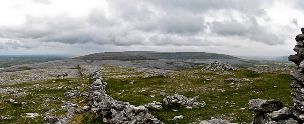
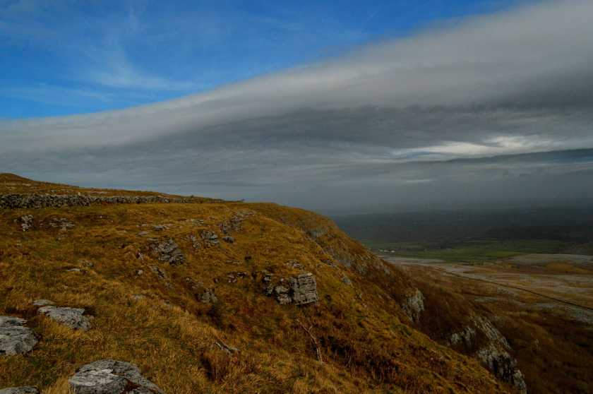
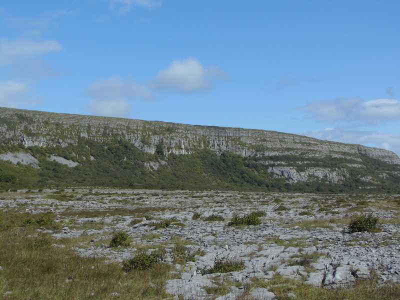
I'm surprised Slievecarran hasn't been commented on already, seeing as its so prominent, interesting and accessible, so I'll give a quick rundown of some of its many charms. It may not be very tall or dramatic, but it catches the eye from lots of places around Galway city and Salthill, rising across the bay with its flat summit, prominent cairn and grey limestone sides. It also holds your attention when driving along the Galway to Gort road, being particularly enticing when the winter sun shines on its grey flanks.

Its easy to climb Slievecarran from the nature reserve southwest of Kinvarra, just park beside the gate and information board around Sl'Carn (M3304 0329)
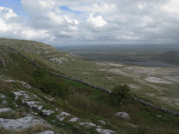
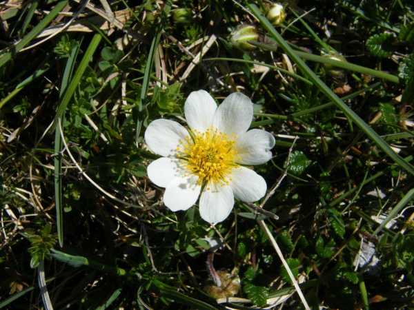
. From here, head through the gate and along the track across the limestone pavement, where the typical Burren flora is present in abundance, especially in late April/May. Among many others, you cant miss the cushions of Dryas octapetala, the mountain avens, with its white flowers, prominent yellow stamens and lobed leaves. You soon pass through another gate in a wall, from where you can head off the track up the hill to the left.

However, a trip to the ruined church and holy well is not to be missed, so follow the path onwards, under the cliffs of Slievecarran, where eagles apparently once nested. The ruins of the church and its attendant holy well (at D (M3286 0425)) are located in a delightful area of hazel woodland, there's also a small cave just up the hill.

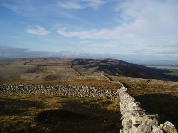
Once you've explored the church, head back towards the second gate and veer off to the obvious shoulder, left of the cliffs. Follow this up over steep, broken limestone ground, the trickiest part is early on, where you have to cross a large wall, amongst thick hazel scrub, on top of a 3m rock step. From here, veer right above the cliffs, until you reach the large, flat summit plateau, which is surprisingly grassy and agricultural. Head in a northerly direction, aiming for a prominent concrete cattle enclosure, over heavily poached ground. Once through the enclosure the huge summit cairn is in sight. In the last couple of hundred metres before the summit the rare, beautiful Arctic-Alpine Spring gentian, Gentiana verna, with its blue trumpet-like flowers, is very abundant. From the cairn, on a clear day, there should be nice views of Galway Bay and city, as well as up to Connemara. From here I retracted my steps, but you could continue down to the north and back around to the church, but I have a feeling you might have a lot of difficult hazel scrub to push through. Linkback: mountainviews.ie/summit/927/comment/4596/
Read Less
Read More

            MountainViews.ie picture about Slievecarran (<em>Sliabh Cairn</em>)
Picture: Mountain Avens
Mountain Avens for Scapania
by paddyhillsbagger 24 May 2010
Having got Wood Anemone mixed up with my Mountain Avens, I eventually came across the real Mountain Avens on the hills of Burren. Many thanks to Scapania for putting me right! I did find more of the Avens on Abby Hill rather than Slievecarran but its about on both. Also came across the Spring Gentian as described on above comment so no need for the guide book. A delightful hill with stunning views in the glorious sunshine. Linkback: mountainviews.ie/summit/927/comment/5822/
Read Less
Read More

            MountainViews.ie picture about Slievecarran (<em>Sliabh Cairn</em>)
Picture: Slieve Carran
One of my favourites in the Burren
by Damian120 6 Jan 2018
Slieve Carran is an easy enough climb but still offers up some astounding scenery overlooking Eagle's Rock. At the summit, there's a huge megalithic cairn that has never been excavated. Take your time walking across the limestone as it can be deceptive in many parts. Linkback: mountainviews.ie/summit/927/comment/19836/
Read Less
Read More

            MountainViews.ie picture about Slievecarran (<em>Sliabh Cairn</em>)
Picture: The cliff face on the south east side of Slieve Carran
Nature reserve in the Burren
by TommyV 5 Jul 2019
There is room for a number of cars at the at the entrance to Keelhila Nature Reserve at Sl'Carn (M33087 03304). Follow the waymarkers through the reserve and ascend Bouleevin from the road at LmPuca (M33699 03039) heading south where a short climb will bring you to the summit. Follow the ridge north for about 2 kilometers to spot height 205. From here descend north west along a wall to the road. From the road look for a passable gap on the other side to get access to Slieve Carran, I managed to find a spot at E (M34523 05047). Ascend Slieve Carran from the east where some bushes will need to be navigated. Once at 300 meters it is easy to spot the massive cairn at the summit. When ascending its nice to walk along by the cliff looking down on the nature reserve. Follow the cliff in a southerly direction before descending down to Keelhila Nature Reserve taking a short detour to take in St Colmans Church and Holy Well at F (M32899 04244). From here it's a short walk back to the start point. Linkback: mountainviews.ie/summit/927/comment/20090/
Read Less
Read More
EDIT Point of Interest
text
Videos
Recent Contributions
x
Conditions and Info
Use of MountainViews is governed by conditions and a privacy policy.
Read general information about the site.
Opinions in material here are not necessarily endorsed by MountainViews.
Hillwalking is a risk sport. Information in comments, walks, shared GPS tracks or about starting places may not be accurate for example as regards safety or access permission. You are responsible for your safety and your permission to walk.
See the credits and list definitions.

OSi logo
OSNI/LPS logo
Open Street Map
(Various variations used.)
British summit data courtesy:
Database of British & Irish Hills