Members and Supporters, the MountainViews Committee requests your help to meet the costs of the website and of other activities such as insured events or publications.
Feature count in area: 14, all in Clare,
OSI/LPS Maps: 51, 52, 57, 58
Highest Place: Slievecallan 391m
Starting Places (16) in area West Clare: Abbey Hill, Ballyvaughan, Ballyvelaghan Lough, Ben Dash, Derroolagh, Feenagh, Fermoyle Cottage, Glenfort, Leimaphuca, Lough Gaelan, Murroogh, Murrooghtoohy CP, Slieve Callan Wind Farm, Slieve Elva, Slievecarron, Toberkieran
Summits & other features in area West Clare: Cen: Ennistymon Hills: Clifden Hill 189m, Knocknalarabana 204m NE: Burren East: Abbey Hill 240m, Bouleevin 222m, Knockanes 205m, Mullagh More 180m, Slievecarran 326m NW: Burren West: Aillwee 304m, Gleninagh Mountain 316.1m, Slieve Elva 344m S: Ennis Hills: Ben Dash 267m, Cloontohil 190m, Slieveacurry 255m, Slievecallan 391m
Note: this list of places may include island features such as summits, but not
islands as such.
Slieve Elva, 344mHill Sliabh Eilbhe A name in Irish,
Place Rating ..
(Ir. Sliabh Eilbhe [logainm.ie], 'mountain of Eilbhe'), Clare County in Munster province, in Binnion Lists, Slieve Elva is the second highest hill in the West Clare area and the 1066th highest in Ireland.
Grid Reference M15059 04412,
OS 1:50k mapsheet 51 Place visited by: 88members, recently by: Carolyn105, trevorf, annem, Ghreallaigh, paulbrown, finkey86, melohara, Oileanach, OisinD, FrankMc1964, geohappy, Damian120, sammullangalvin, Wilderness, conormcbandon
I visited this place: NO (You need to be a logged-in member for this.)
Longitude: -9.268367, Latitude: 53.083836, Easting: 115059, Northing: 204412,
Prominence: 339m, Isolation: 5.8km, Has trig pillar
ITM: 515027 704444 Bedrock type: Grey siltstone & sandstone, (Gull Island Formation) Notes on name: The summit of Slieve Elva is geologically quite different from its slopes, this being the only place in the heart of the Burren where the layer of shale above the limestone has not been eroded away. This shale cap makes the top of Slieve Elva surprisingly boggy, and therefore it tends to be explored only by determined peak-baggers. An entry for A.D. 239 in the Annals of the Four Masters records the seven battles of Eilbhe (Mount Elva) by Cormac, son of Art, son of Conn of the Hundred Battles, King of Ireland. Walks: for a route on the NE slopes of Slieve Elva, see Kevin Corcoran, West of Ireland Walks, 20-29; for one including the slopes of Slieve Elva with Gleninagh Mountain and Black Head, see Whilde & Simms, New Irish Walk Guide - West and North, 22-23.
Short or GPS IDs, 6 char: SlvElv, 10 char: SlvElva Linkback: https://mountainviews.ie/summit/906/
Gallery for Slieve Elva (Sliabh Eilbhe) and surrounds
Climbed Slieve Elva in May 2016, on two occaisons. Slieve Elva is very spongey as many have mentioned previously, this is due to the fact it is a peat bog. Peat is very wet meaning sphagnum moss is primarilly the main vegetation as well as in parts heather and grass. The moss makes walking feel more difficult as you are having to push yourself upwards and forwards with every step. It can get particularly boggy in areas, usually around the lighter green mosses. If you see any bright green moss walk around it as you could be waist deep in brown sludge (peat)! Slieve Elva is cut for fuel production in certain areas so be particularly careful for crevasses in the ground. I would walk around these too as vertically below the edge of the cuttings, is more bog that you don't want to be stepping in. I would advise walking on the dry grass areas and heather areas as the rooting is much deeper than moss making it more stable for walking. However, when at these crevasses grass may cover bogs so jump a few feet over the edge to the middle and similarly when getting out. Beautiful views from the summit; the Burren, Aaron Islands and Cliffs of Moher. Linkback: mountainviews.ie/summit/906/comment/18521/
Read Less
Read More
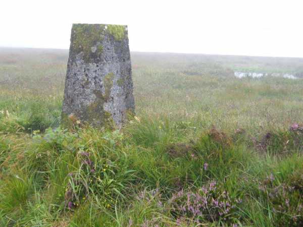
Picture: Mist and bog in the Burren
Boggy Burren
by paddyhillsbagger
1 Aug 2011
Parked car at A (M162 035) where there is a small layby opposite an entrance gate with piers engraved with Slieve Elva. Walked up forestry track past shed with badly weathered red corrugated iron doors. Took a left uphill on side track through trees which leads to bog area and onto summit plateau with old machinery mentioned by mindhealing. Trig is visible on rise roughly North from here. It's a short boggy walk to trig. About an hour up and down with time for snaps. Sadly I had no views through low mist but they should be fabulous in clear weather. Linkback: mountainviews.ie/summit/906/comment/6450/
Read Less
Read More
Spongy, even in dry weather.
by garrettd
15 Oct 2013
Climbed this summit as part of a backpack. We camped at the holy well about 1km to the north of the summit beside a green road contouring around the northern fringe of the peak. The ground is very soft and although reasonably dry, it took great effort to trudge through spongy moss and heather. There is very little exposed limestone on Slieve Elva, unlike some of the other peaks nearby such as Gleninagh or Cappanwalla. I would avoid this area after heavy rain if at all possible. Linkback: mountainviews.ie/summit/906/comment/15230/
Read Less
Read More
mindhealing on Slieve Elva
by mindhealing
15 Dec 2009
I walked this hill on A clear December day from the south-east. A road runs up to the masts and then it was flat across the bog towards the north and the trig point. Good views of the Burren, the Aran Islands and the mountains of Connemara. The lake marked on the OS map is very small (10*30 feet). Could this be the smallest lake to appear on the OS? A rusting turf cutting machine is abandoned up here, otherwise it is very quiet and untouched, in recent times. (I am reminded that the Burren was presumably tree covered at one time, so the 'pristine' nature of the landscape may be an illusion of sorts!). A faux trig point is positioned on the northern slope, which is about three times the usual size and made of loose stones. There is no indication of its significance, but it is very neatly built of stones that were carried some distance, and doesn't seem like the usual new age graffiti. Dropping down this slope there is a green road which makes a convenient walk out. It is very wet on top being bog and not Burren limestone. This circuit took 3 hours and was easy to moderate in effort. Given the soft terrain, it is good exercise. Linkback: mountainviews.ie/summit/906/comment/4294/
Read Less
Read More
buny clare on Slieve Elva
by buny clare
9 Jan 2009
Climbed Slieve Elva yesterday 08/1/09. Left car at Faunarooska above Fanore and approached
Slieve Elva from the North East ...a comfortable 3 hour trek, Linkback: mountainviews.ie/summit/906/comment/3517/
Use of MountainViews is governed by conditions and a privacy policy.
Read general information about the site. Opinions in material here are not necessarily endorsed by MountainViews.
Hillwalking is a risk sport. Information in comments, walks, shared GPS tracks or about starting places may
not be accurate for example as regards safety or access permission. You are responsible for your safety and your permission to walk.
See the credits and list definitions.


 Our Facebook page.