Donation Request 2024

DONATE
Members and Supporters, the MountainViews Committee requests your help to meet the costs of the website and of other activities such as insured events or publications.
You do not have to be logged in to donate.
Features
Nearby features appear when you click the map.
Declutter tracks on map.
Place Search
Video
X
Pub: by
Donegal Central Area , NE: Loughsalt Hills Subarea
Feature count in area: 15, all in Donegal, OSI/LPS Maps: 1, 2, 6
Highest Place: Moylenanav 539m

Starting Places (28) in area Donegal Central:
Astelleen Burn Waterfall, Ballyarr, Binnadoo, Braughan Road, Drumfin Bridge, Edenacarnan East, Edenacarnan North, Edenacarnan South, Garrangalta Rocks, Gartan Wood, Glenveagh Bridge, Glenveagh National Park SW, Glenveigh Castle, Losset North, Lough Acrobane Farmhouse, Lough Acrobane South, Lough Acrobane South West, Lough Barra Slipway CP, Lough Barra W, Lough Natooey West, Lough Salt North, Lough Salt West, Moyle Hill, Nabrackbaddy Lough, Parochial House, River Barra Bridge NE, River Barra Bridge SW, Sruhancrolee Bridge

Summits & other features in area Donegal Central:
NE: Loughsalt Hills: Crockmore 349m, Croaghmore 278m, Edenacarnan 192m, Loughaskerry 252m, Loughsalt Mountain 469m, Moyle Hill 148m, Stragraddy Mountain 285m
SW: Glendowan Mountains: Binswilly 337m, Brown Mountain 224m, Cionn Bheatha 384m, Crockastoller 418m, Farscallop 420.6m, Gartan Mountain 357m, Leahanmore 442m, Moylenanav 539m

Note: this list of places may include island features such as summits, but not islands as such.
Rating graphic.
Crockmore, 349m Hill An Cnoc Mór A name in Irish,
Place Rating ..
(prob. Ir. An Cnoc Mór [PDT], 'the big hill'), Donegal County in Ulster province, in Binnion Lists, An Cnoc Mór is the 1061th highest place in Ireland.
Grid Reference C10129 25914, OS 1:50k mapsheet 2
Place visited by: 21 members, recently by: Lucky1, cody1, Fergalh, IndyMan, AntrimRambler, jackill, chalky, David-Guenot, mark-rdc, Garmin, jmcg, slemish, hgboyle, three5four0, bellanascadden
I visited this place: NO (You need to be a logged-in member for this.)
Longitude: -7.842198, Latitude: 55.080424, Easting: 210129, Northing: 425914, Prominence: 173m,  Isolation: 2.3km
ITM: 610076 925897
Bedrock type: Coarse biotite granite & granodiorite, (Main Donegal Granite)
Notes on name: Located in the townland of An Bearnas Uachtarach / Barnes Upper (par. Kilmacrenan), this peak lies to west of Loughsalt Mountain on the other side of Lough Salt and Lough Greenan.
  Short or GPS IDs, 6 char: Crckmr, 10 char: Crockmore

Linkback: https://mountainviews.ie/summit/901/
Gallery for Crockmore (An Cnoc Mór) and surrounds
No summary yet for this place .
Member Comments for Crockmore (An Cnoc Mór)
Comment create / edit display placeholder

            MountainViews.ie picture about Crockmore (<em>An Cnoc Mór</em>)
Picture: View north to the high Derryveaghs from Crockmore summit
'the big hill' with the small cairn
by slemish 8 Nov 2011
Crockmore is another of the hills in this part of Donegal that I had been meaning to climb for a very long time, having spent many summers in the area since 1978. Once again I lucked out with the weather - a fine and sunny November morning and an almost cloudless sky. I followed the minor road from the N56 (signposted Min Larach) for about 2km. There is space for several vehicles to park on a little patch of gravel beside the road ( Bndoo (C106 254)).

From here there is an obvious col to head for between the main summit to the left and the lower hill to the right. The going is tough enough up to the lower hill summit, fairly steep and through dense heather, energy-sapping grass and slippery granite. After all the recent rain some parts were like walking through treacle and I found that I had to use my hands on several occasions to get myself up steep and slippy sections. The heather is a useful aid to grab on to. Near the top of this section, two large hares leapt out of a burrow in the ground in front of me and ran off.

Crockmore is one of those frustrating hills where you have to go down to continue going up. The main summit lay directly ahead but I had to descend again down more slippery rocks to the col to reach it. I was already feeling the strain at this point but managed to haul myself up the last section to the 349m summit where I encountered the smallest cairn I have ever seen - literally about half a dozen stones in a little pile.

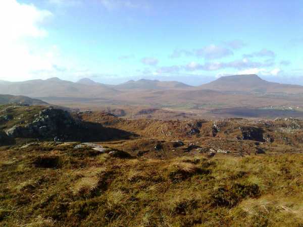
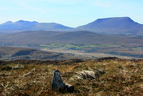
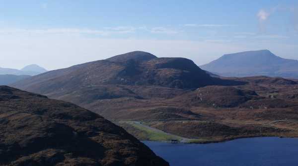
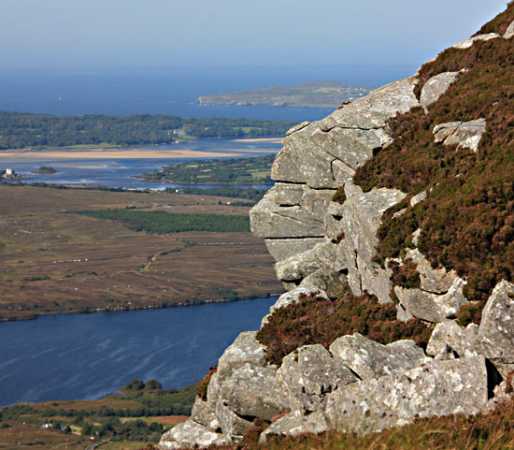
My reward was to drink in the fantastic views - the rest of the Derryveagh Mountains looked splendid in the sunshine, particularly the ridge from Dooish past Errigal and the Aghlas to mighty Muckish. Loughsalt Mountain blocks much of the view out to Inishowen but the hills of Fanad, Rosguill and Horn Head were on full display - I counted eight other tops I had previously climbed. Through the haze out to sea I could just make out Tory Island.

The excellent views and warm weather kept me on the summit for some time but eventually I had to retreat. Having reached the col again I headed SE directly back towards the car across the eastern face of Crockmore. Took longer than expected - just over an hour up and down - but well worth it on a day like this. Linkback: mountainviews.ie/summit/901/comment/6617/
Read Less
Read More

            MountainViews.ie picture about Crockmore (<em>An Cnoc Mór</em>)
Picture: The small summit with a big view to the Errigal-Muckish ridge.
by simon3 5 May 2023
This summit can add to the rather short day that Loughsalt Mountain makes. Unlike that quartzite summit it is made of granite, has no paths and few people. Start from the tee junction on the N56 at L Acro S (C09182 24431) where there is some parking. You can ascend over a waste strewn small cutting here if you don't mind a bit of scrambling or you can go to around L Acro SW (C0906 2469) which takes you up past Lough Acrobane. Study the ridges of the land and if you pick carefully you can do a lot of the walking on some of the long bare ridges of rock that arc upwards.

The summit has a few steep bits. There are good views of much of north Donegal, though not as good as Loughsalt Mountain which blocks the panorama.

The photo shows the ridge towards Errigal starting from Muckish at the right. Linkback: mountainviews.ie/summit/901/comment/4103/
Read Less
Read More

A short hill walk in Donegal
by three5four0 5 May 2023
From the small area, where you can squeeze in a car or perhaps two at L Acro S (C09182 24431), it is roughly one and half hours return to the summit of Crockmore. We walked along the road to L Acro SW (C0906 2469), where there is a faint path towards Lough Acrobane, mentioned in simon3's route description, crossing the river by a hidden bridge and then recrossing it to reach the bottom of the ridge to the right of the wide gully. (A (C09353 24910), B (C09476 24958), C (C09482 25168) being the gps points to get to the ridge) Follow this ridge uphill, past a stick sticking out of a piece of plastic tubing, to the first top, then a dip and the final short slope to the summit. Views are good and there was still a hint of strange colour in the approaching shower clouds, volcanic ash still about then. Linkback: mountainviews.ie/summit/901/comment/4739/
Read Less
Read More

            MountainViews.ie picture about Crockmore (<em>An Cnoc Mór</em>)
Picture: Crockmore across Lough Greenan
gerrym on Crockmore
by gerrym 1 Nov 2009
Crockmore can be easily approached from the carpark at Loughsalt (D (C122 262)). A morning climb on Loughsalt Mtn left ample time to explore Crockmore and other hills in Donegal.

It was a very foggy morning and i dropped straight off the back of the carpark - Lough Greenan soon came into view several hundred feet below. There is an old disused track heading down which explained the surreal appearance of large pieces of furniture in the middle of nowhere. On reaching the shores of the lough i tracked its edge towards the road and pumping station seen in the picture. This was a nightmare of really rough ground and all sorts of vegetation which seemed to go on forever - a really good clue as to a bad route - the advice is do not go this way unless you like a bit of punishment!

Reach the road (approx E (C113 260)) at the small pumping house - this could be another alternative starting point with plenty of parking and a decent road. Cross road and head up the lower slopes of Crockmore. A sheeptrack (which has also seen a few bootprints) heads straight up to the first height which has a number of rocky outcrops at 307 m (. From here there is a clear view of the top as drop and then climb to the top. Pretty straightforward and the last of the mist was clearing as i made my way up allowing fantastic views. The summit has the little stone perched which can be seen in Simon's photo. Views north were dominated by the waters of Glen Lough and the Atlantic as it met the sweeping strandsin Sheephaven Bay. The old stone pillars of the railway viaduct which crossed the Owencarrow river are also clearly visible. To the west the clear autumn day brought Muckish, Aglas and Errigal close- as the eye roamed south the Bluestacks were not hard to miss. Looking back to whence i had come i could see my car perched high in the carpark next to a still mist enveloped Loughsalt. Noise was coming from the big working quarry on the southern flank of Loughsalt.

On the descent i did not return to the height of 307m but easily contoured down the south side to the road. The clear weather now showed the preferred route back (and there!) which was to climb to the heights above Lough Greenan to follow the ridge which leads back to the carpark at Loughsalt. This was great walking with views over a wide area of Donegal.

A walk of just over 3 miles and just over 1.5 hours. There were people about Lougsalt but no one else on the journey to Crockmore (unless you count the farmer on a really old tractor heading about his business). Linkback: mountainviews.ie/summit/901/comment/4235/
Read Less
Read More

            MountainViews.ie picture about Crockmore (<em>An Cnoc Mór</em>)
Picture: Views from Crockmore
simon3 on Crockmore
by simon3 16 Sep 2009
On the way up Crockmore there are fine views NW such as this over Glen Lough (nearer water) towards Sheep Haven and the Atlantic. The whitish strand is probably Ards Strand in the Ards Forest Park. Linkback: mountainviews.ie/summit/901/comment/4104/
Read Less
Read More
EDIT Point of Interest
text
Videos


Recent Contributions
x
Conditions and Info
Use of MountainViews is governed by conditions and a privacy policy.
Read general information about the site.
Opinions in material here are not necessarily endorsed by MountainViews.
Hillwalking is a risk sport. Information in comments, walks, shared GPS tracks or about starting places may not be accurate for example as regards safety or access permission. You are responsible for your safety and your permission to walk.
See the credits and list definitions.

OSi logo
OSNI/LPS logo
Open Street Map
(Various variations used.)
British summit data courtesy:
Database of British & Irish Hills