Cookies.
This website uses cookies, which are small text files that the website puts on your device to facilitate operation. Cookies help us provide a better service to you. They are used to track general user traffic information and to help the website function properly.
Features
Nearby features appear when you click the map.
Declutter tracks on map.
Place Search
Video
X
Pub: by
West Connemara Area , N: Tully Subarea
Feature count in area: 4, all in Galway, OSI/LPS Maps: 37
Highest Place: Tully Mountain 356m

Starting Places (15) in area West Connemara:
Bridge St Clifden, Bundouglas Bay, Cleggan House, Coorhoor Lough North, Gortdrummagh West, Letterfrack Lodge, Lough Natawny, Lough Tanny, Omey Strand, Owen na Baunoge River, Ross Beach, Ross Point, Skeaghatimull, Sky Road, Tievegarriff

Summits & other features in area West Connemara:
N: Cleggan: Knockaunbaun 146m, Maumfin 172m
N: Tully: Tully Mountain 356m
S: Clifden: Gortrumnagh 174m

Note: this list of places may include island features such as summits, but not islands as such.
Rating graphic.
Tully Mountain, 356m Hill Cnoc Leitreach A name in Irish,
Place Rating ..
(Ir. Cnoc Leitreach [logainm.ie], 'hill of the wet slope') Letter Hill an extra name in English, Galway County in Connacht province, in Binnion Lists, Tully Mountain is the highest hill in the West Connemara area and the 1048th highest in Ireland. Tully Mountain is the most northerly summit in the West Connemara area and also the most easterly.
Grid Reference L67272 61173, OS 1:50k mapsheet 37
Place visited by: 98 members, recently by: annem, dominic divilly, Wilderness, maitiuocoimin, Taisce, chelman7, ahogan, trevorf, nickywood, philmchale, wicklore, TommyMc, Lauranna, pdtempan, odrisceoil146
I visited this place: NO (You need to be a logged-in member for this.)
Longitude: -10.004897, Latitude: 53.583789, Easting: 67272, Northing: 261173, Prominence: 331m,  Isolation: 3.4km, Has trig pillar
ITM: 467251 761193
Bedrock type: Pale quartzites, grits, graphitic top, (Bennabeola Quartzite Formation)
Notes on name: Tully Mountain is sufficiently detached from the Twelve Bens to offer fine views of the range as a whole, as well as coastal views including Inishbofin, Inishturk, Clare Island and Achill. Also known as Letter Hill [TR]. Walks: a route for this peak is described in New Irish Walk Guides by Tony Whilde and Patrick Simms, p. 44.
  Short or GPS IDs, 6 char: TlyMnt, 10 char: TlyMntn

Linkback: https://mountainviews.ie/summit/893/
Gallery for Tully Mountain (Cnoc Leitreach) and surrounds
Summary for Tully Mountain (Cnoc Leitreach): Photo for Tully
Summary created by simon3 2020-02-16 17:40:28
            MountainViews.ie picture about Tully Mountain (<em>Cnoc Leitreach</em>)
Picture: Photo from the south.
Full short summary required.
Linkback: mountainviews.ie/summit/893/comment/5652/
Member Comments for Tully Mountain (Cnoc Leitreach)

            MountainViews.ie picture about Tully Mountain (<em>Cnoc Leitreach</em>)
Picture: The view east from Tully, to Croagh Patrick, Mweelrea, Benchoona and the Bens
A fantastic viewpoint
by scapania 23 May 2010
Tully makes a lovely easy stroll if you're in the Renvyle/Letterfrack area with a couple of hours to spare, or could be combined with a trip to the Connemara National Park and a round of the Diamond to make a satisfying, leisurely day out. There's space to park a couple of cars in a small quarry at SkTiml (L6839 5999), just after two tracks go off to the right, or else there's loads of parking a few hundred metres back along the road at the quay at A (L6878 5985).

From the first mentioned parking place, head west along the road for a few metres, until you can see a little wooden stile over the fence above you to the right. Once over this, head up to the broad ridge, from where its an easy climb, firstly over short, relatively dry grass and then closely cropped heather. Higher up, look out for the abundant shiny leaved, trailing shoots of the Bearberry (Arctostaphylos uva-ursi) and the spiky leaved mats of Juniper (Juniperus communis), forming a very attractive type of heath.

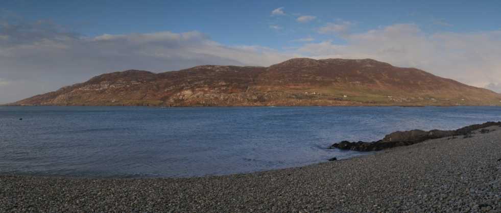
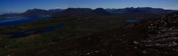
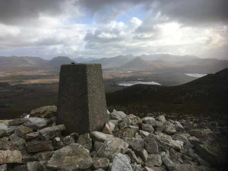
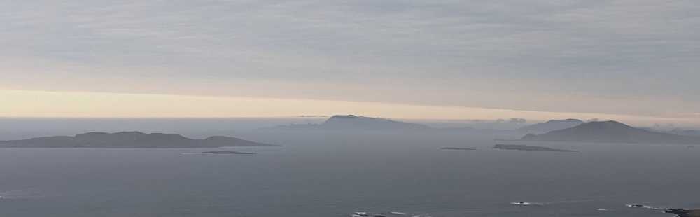
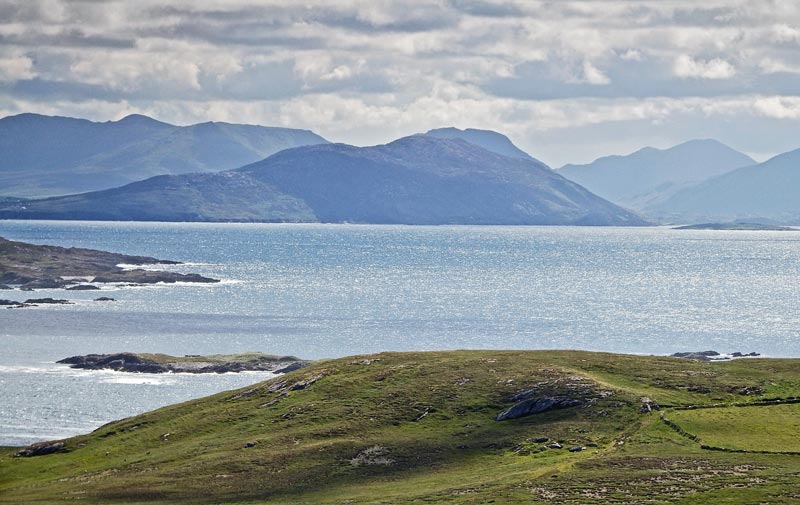
There is one false summit to contend with, but once this is surmounted, the main summit is close at hand, with its trig pillar almost completely enclosed within a cairn. The view from here is nothing short of stupendous, due to Tully's isolated location, west of all the other mountains. Views stretch from south Connemara, across the Bens, to Mweelrea with its golden beaches, up to Croagh Patrick and the North Mayo mountains, out to Achill, which still managed to be completely covered by cloud, despite there not being another cloud in the sky! Out to sea lay Clare, Bofin, Turk and Shark, surprisingly close at hand.

Once you've soaked up the scenery, you can either retrace your steps back to the starting point, or if you want a longer walk and don't mind a few kilometres of road walking, you could continue west along the ridge crossing a couple of minor tops to come down to the road near Renvyle point. Linkback: mountainviews.ie/summit/893/comment/5821/
Read Less
Read More

            MountainViews.ie picture about Tully Mountain (<em>Cnoc Leitreach</em>)
Views from NW Connemara
by bryanmccabe 4 Nov 2017
Tully Mountain trig pillar, with Doughruagh, Diamond Hill and the Northern Bens in the background. Delightful views in all directions. Well worth walking the whole ridge NW to the coast, to include Tully Mountain West. Linkback: mountainviews.ie/summit/893/comment/19780/
Read Less
Read More

            MountainViews.ie picture about Tully Mountain (<em>Cnoc Leitreach</em>)
Lockdown photo #3
by timredfern 20 Jan 2021
I climbed Tully mountain ~140 times during the Cov-19 pandemic. Here are a few of my favourite photos Linkback: mountainviews.ie/summit/893/comment/22141/
Read Less
Read More

            MountainViews.ie picture about Tully Mountain (<em>Cnoc Leitreach</em>)
Lockdown photo #7
by timredfern 20 Jan 2021
I climbed Tully mountain ~140 times during the Cov-19 pandemic. Here you can see Mweelrea, Croagh Patrick and Nephin Beg with snowy caps. Linkback: mountainviews.ie/summit/893/comment/22145/
Read Less
Read More

            MountainViews.ie picture about Tully Mountain (<em>Cnoc Leitreach</em>)
Picture: Tully Mountain, the sea view.
Sweeping down to the sea.
by simon3 7 Jul 2014
It was a day of sun and showers on which we visited Inishark. From it there is a quite different NE view of Tully Mountain, shown in relation to its neighbours.

Tully, centre midground, sweeps down to the sea from this angle. On the skyline to the right is Garraun and its outliers. Just beyond Tully is the ever dark Doughruagh. From the right is the NE flank of Diamond Hill. Perhaps most surprising is the skyline between Tully and Diamond where the stepped ridge descends (r to l) from Letterbreckaun 40.01 km away in the Maamturks.

Nearer at hand the SW coast of Inishbofin creeps in from the left of the picture. The small island between Inishbofin and Inishark rejoices in the anglicisation of Inishskinnymore. Linkback: mountainviews.ie/summit/893/comment/17536/
Read Less
Read More
EDIT Point of Interest
text
Videos


Users Online

Guests online: 328
Recent Contributions
x
Conditions and Info
Use of MountainViews is governed by conditions and a privacy policy.
Read general information about the site.
Opinions in material here are not necessarily endorsed by MountainViews.
Hillwalking is a risk sport. Information in comments, walks, shared GPS tracks or about starting places may not be accurate for example as regards safety or access permission. You are responsible for your safety and your permission to walk.
See the credits and list definitions.

OSi logo
OSNI/LPS logo
Open Street Map
(Various variations used.)
British summit data courtesy:
Database of British & Irish Hills