This website uses cookies, which are small text files that the website puts on your device to facilitate operation. Cookies help us provide a better service to you. They are used to track general user traffic information and to help the website function properly.
Feature count in area: 27, by county: Mayo: 15, Galway: 15, of which 3 are in both Galway and Mayo,
OSI/LPS Maps: 37, 38, CBE, EW-CON, MSW
Highest Place: Maumtrasna 682m
Starting Places (54) in area Partry & Joyce: Aasleagh Waterfall CP, An Móinín Mór, Ballydoo Lough, Barrevagh Bridge, Bealanabrack River Tributary, Black Rock, Bohaun, Bracklagh, Buckaun, Bunduvowen, Cammanagh, Carraig Bar, Carrowrevagh Lough, Clonbur, Cummer, Derrassa, Derrinkee Wood, Doon Rock, Failmore River, Finny Church, Fooey River Road, Glendavock, Glenmask, Glennacally Bridge, Glensaulmore Trailhead, Glentraigue, Gowlaunlee Lake, Keelkill North, Killeennimat Burial Ground, Knockaunnabausty (Cnocán na bPáistí), Knocknafaughy SW, L Mamwee, Lecarrow, Leenane, Leenane Hotel, unuseableLeenane R336, Lough Nambrackkeagh, Maum Bridge Road Lower, Maum Bridge Road Mid, Maum Bridge Road Upper, Mount Gable CP, Otter Pool, Owenbrin Bridge, Owenbrin Tributary, Owenduff River, Red Island, RIC Barracks Ruin, Rinavore East, Rinavore SW, Shanafaraghhaun Cross, Sheeffry Pass, Tawnyard Lough, Teevinish West, The Larches Pub
Summits & other features in area Partry & Joyce: Cen: Finny: Glenbeg East 372m Cen: Knocknafaughy: Knocknafaughy 254m, Rinavore 426m Cen: Maumtrasna: Barnahowna 516m, Buckaun East 495m, Glennagleragh Mtn 617m, Knocklaur 518m, Maumtrasna 682m, Maumtrasna North-East Top 572m, Tullymorehill 279m N: Ballintober Hills: Bohaun 393m, Corveagh 233m, Croaghrimkarra 271m, Keelkil 239m SE: Cornamona: Mount Gable 417.8m, Bohaun 424m, Knocknagussy 456m SW: Bunnacunneen: Ben Beg 560m, Bunnacunneen 575m, Bunnacunneen South Top 539m, Bunnacunneen SE Top 479m, Lugnabrick SW Top 494m, Lugnabrick NE Top 494m W: Devilsmother: Devilsmother 645m, Devilsmother South Top 509m, Devilsmother North Top 595m, Devilsmother Far North Top 601m
Note: this list of places may include island features such as summits, but not
islands as such.
Glenbeg East, 372mHill
Place Rating ..
, Mayo County in Connacht province, in Binnion Lists, Glenbeg East is the 1014th highest place in Ireland.
Grid Reference M03615 59955,
OS 1:50k mapsheet 38 Place visited by: 28members, recently by: eamonoc, elizauna, TommyV, bryanmccabe, obrien116, Fergalh, magnumpig, markmjcampion, patmoran, OisinD, markwallace, Cobhclimber, Garmin, sandman, Wilderness
I visited this place: NO (You need to be a logged-in member for this.)
Longitude: -9.455989, Latitude: 53.580785, Easting: 103615, Northing: 259955,
Prominence: 267m, Isolation: 4.5km ITM: 503586 759975 Bedrock type: Volcanic breccia, tuff, lava, chert, (Finny Formation) Notes on name: This peak is unnamed on OS maps. It lies on the boundary of the townlands of Glenbeg East, Glenbeg West and Kilbride. Any information on the correct name of this hill would be welcome.
Short or GPS IDs, 6 char: GlnbEs, 10 char: GlnbgEast Linkback: https://mountainviews.ie/summit/875/
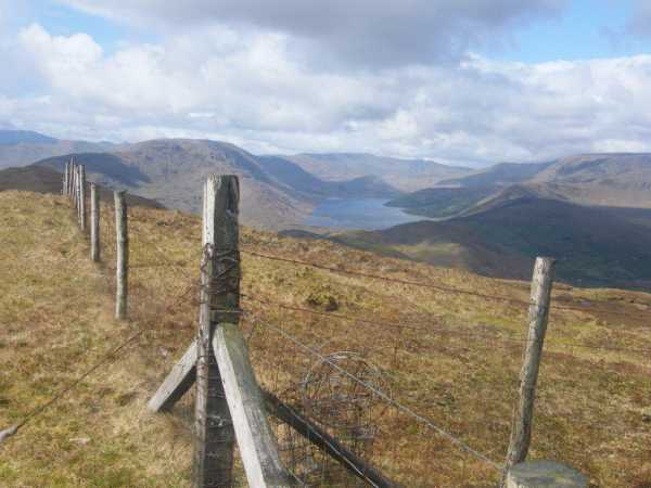
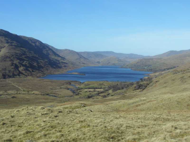
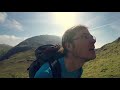
Picture: Glenbeg E summit looking up Lough Nafooey to Leenaun Hill
Marvelous views!
by paddyhillsbagger
22 Apr 2012
Visiting friends near Headford, I left the wife in bed to bag this delightful little hill. Despite taking a few wrong turns, I parked the car opposite a house at Doon Rk (M049 596) after asking the owners who were in the process of painting the property white. Setting up the slope in a NW direction with the sound of Yellowhammers, Skylarks, Meadow Pipits and Willow Warblers in my ears I quickly came across steeper ground and a false summit to a slightly boggy and undulating summit ridge. I made my way to a fence which runs along the spine of the hill and in the absence of trig, chose the point where the ridge fence is joined by a fence from the northern slope as the summit point. Fine views are had all round taking in Loughs Mask, Corrib and Nafooey as well as the Partry Mountains, Joyce Country with the higher Maumturks just visible above the closer summits. A wonderfuly panoramic scene for a short climb! Linkback: mountainviews.ie/summit/875/comment/6779/
Read Less
Read More
Northern Side.
by sandman
7 May 2017
If you wish to follow the fence on the northern slope mentioned in the previous comment up to the summit area park at Red Isl (M03186 60799) entering thru a farm road gate then taking the lower gate and by keeping the fence on your left ,but picking your route you will arrive after a nice steep accent. Linkback: mountainviews.ie/summit/875/comment/18914/
Read Less
Read More
Along the ridge
by bryanmccabe
16 May 2021
The routes proposed by paddyhillsbagger and sandman are short and steep. If you want a longer and more gradual ascent, you can start in the vicinity of the parking area at Cum'r (M0044 5977) and follow the high ground, gradually curving around clockwise onto the main ridge. Alternatively park at Finny Church and incorporate a short road walk to get to this parking area. A decent effort needed to bag this binnion. Linkback: mountainviews.ie/summit/875/comment/23119/
Read Less
Read More
Picture: Looking down at Lough NaFooey
Follow the fence
by TommyV
24 Mar 2022
As mentioned by bryanmccabe I started from the Western side of the hill at the parking area. Once you get to the first spot height at 203 metres you will see a fence that you can follow for the most part all the way to the unmarked summit. There are a few sections where you will need to move away from the fence in search of less steep ground. For a hill under 400 metres it does take a bit of effort, or maybe it's just that this was my first hike in months. Linkback: mountainviews.ie/summit/875/comment/23434/
Use of MountainViews is governed by conditions and a privacy policy.
Read general information about the site. Opinions in material here are not necessarily endorsed by MountainViews.
Hillwalking is a risk sport. Information in comments, walks, shared GPS tracks or about starting places may
not be accurate for example as regards safety or access permission. You are responsible for your safety and your permission to walk.
See the credits and list definitions.


 Our Facebook page.