Donation Request 2024

DONATE
Members and Supporters, the MountainViews Committee requests your help to meet the costs of the website and of other activities such as insured events or publications.
You do not have to be logged in to donate.
Features
Nearby features appear when you click the map.
Declutter tracks on map.
Place Search
Video
X
Pub: by
West Clare Area , S: Ennis Hills Subarea
Feature count in area: 14, all in Clare, OSI/LPS Maps: 51, 52, 57, 58
Highest Place: Slievecallan 391m

Starting Places (16) in area West Clare:
Abbey Hill, Ballyvaughan, Ballyvelaghan Lough, Ben Dash, Derroolagh, Feenagh, Fermoyle Cottage, Glenfort, Leimaphuca, Lough Gaelan, Murroogh, Murrooghtoohy CP, Slieve Callan Wind Farm, Slieve Elva, Slievecarron, Toberkieran

Summits & other features in area West Clare:
Cen: Ennistymon Hills: Clifden Hill 189m, Knocknalarabana 204m
NE: Burren East: Abbey Hill 240m, Bouleevin 222m, Knockanes 205m, Mullagh More 180m, Slievecarran 326m
NW: Burren West: Aillwee 304m, Gleninagh Mountain 316.1m, Slieve Elva 344m
S: Ennis Hills: Ben Dash 267m, Cloontohil 190m, Slieveacurry 255m, Slievecallan 391m

Note: this list of places may include island features such as summits, but not islands as such.
Rating graphic.
Slievecallan, 391m Hill Sliabh Calláin A name in Irish,
Place Rating ..
(Ir. Sliabh Calláin [logainm.ie] , poss. 'mountain of the height') Mount Callan an extra name in English, Clare County in Munster province, in Binnion Lists, Slievecallan is the highest hill in the West Clare area and the 974th highest in Ireland. Slievecallan is the second most southerly summit in the West Clare area.
Grid Reference R14422 77360, OS 1:50k mapsheet 57
Place visited by: 39 members, recently by: Oscar-mckinney, Jai-mckinney, Carolyn105, rquirke27, JohnRea, finkey86, gaoithe, eamonoc, MagdaK, NickDown, FrankMc1964, epona2018, MichaelE, jimbloomer, johnnyireland
I visited this place: NO (You need to be a logged-in member for this.)
Longitude: -9.270725, Latitude: 52.840719, Easting: 114422, Northing: 177360, Prominence: 365m,  Isolation: 3.1km, Has trig pillar
ITM: 514390 677398
Bedrock type: Sandstone, siltstone & mudstone, (Central Clare Group)
Notes on name: Slievecallan is an isolated peak, the highest in SW Clare. Given the altitude and boggy, infertile terrain, Callán/Collán is more likely to be the element meaning 'height' which appears in names such as Sliabh gCallann (Slieve Gallion in Derry) and Collann (Collon, Co. Louth) than coll(-án), 'hazel' . The monuments and place-names on the mountain were the subject of some considerable controversy in the late 18th and 19th centuries, when theories were advanced that rituals of pre-Christian sun worship took place here. See Máire MacNeill, 'The Festival of Lughnasa' (pp. 193-201) for details of the festive assembly on Slievecallan.
  Short or GPS IDs, 6 char: Slvcln, 10 char: Slvcln

Linkback: https://mountainviews.ie/summit/850/
Gallery for Slievecallan (Sliabh Calláin) and surrounds
No summary yet for this place .
Member Comments for Slievecallan (Sliabh Calláin)
Comment create / edit display placeholder

            MountainViews.ie picture about Slievecallan (<em>Sliabh Calláin</em>)
Picture: Sign at wind farm entrance. With route/top approximately marked in pink.
Sliabh Callan through wind farm
by gaoithe 15 Jul 2020
Into wind farm on gravel tracks (around locked gates) to visit Sliabh Callan. Same route as others but can go all the way to the top on gravel tracks now.

Start, from The Hand crossroads West uphill about 1km along the big road to wind farm entrances.

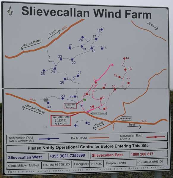
There is a map of the wind farms with numbers to call to contact site operations, officially one would contact the landowner to ask permission. There are two wind farms, Slieve Callan West and Sliabh Callan East with different contact numbers. We entered the West farm but walk was mostly in the East farm.

We went North up track, passing farmhouse.
Then come to intimidating looking gate no trespassing etc. Easy step around gate to left. Passing substation and wind farm work buildings. Uphill passing by some impressive large wind towers.

Closer to top track becomes narrow, in an eroded gulley, gravel paved all the way to the top. Lovely soft boggy terrain. Slate rock. Some forest plantation. Fraghans, foxgloves, . . .

Driving mist down on mountain for us. No views.

Back down we kept to the east, passing by lake and exit climb fence beside locked gate. Careful of yourself and fence, barbed wire. Linkback: mountainviews.ie/summit/850/comment/20818/
Read Less
Read More

Access?
by Jamessheerin 14 Oct 2016
Was passing by yesterday and noticed the activity on the mountain. It is now a building site. Wind turbines are going in everywhere. Because of the forestry north and east access is limited to the south and west. All access roads south and west are now restricted to site traffic. I was informed by security that they couldn't stop me entering by foot but wouldn't recommend it or guarantee my safety! Was also informed that in 18 months when work finishes I could enter the area with no problems. I would take that with a pinch of salt. Derrybrien is severely restricted after the turbines went in. Linkback: mountainviews.ie/summit/850/comment/18654/
Read Less
Read More

            MountainViews.ie picture about Slievecallan (<em>Sliabh Calláin</em>)
Picture: The lonely cairn looking out to my home.....somewhere
The home peak
by TommyV 6 Nov 2018
This mountain has a personal significance for me as I could see it from our kitchen window when I was growing up and I always found myself staring over at it wondering what it was like on top and what the views were like. The mountain now has a windfarm on it and the last time I climbed it the windfarm was under construction. From the R474 at Sl Callan WF (R13554 75614) this road can be followed around to a farm building at A (R13497 76829) where it's possible to then branch off left onto the open mountain to climb a steep hill to the boggy plateau leading to the trig point on the summit.

Lovely views north to the Burren and west along the Clare coast line. Retrace your steps back to the start point. Linkback: mountainviews.ie/summit/850/comment/20094/
Read Less
Read More

            MountainViews.ie picture about Slievecallan (<em>Sliabh Calláin</em>)
Picture: Slievecallan cutting route, trig off to R on summit.
Fine views, inbetween the mist!
by paddyhillsbagger 31 Jul 2011
Left car at forestry entrance on highest point on the R474 Ennis Milltown Malby Rd. Sl Callan WF (R136 756). Walked up tracks serving a house, small quarry, forestry, turf cutting and mast. After passing through a gate, I took a straight line up a cutting to left of forest. This is a steep short climb on rough terrain which leads to a very boggy and uneven summit plateau. Trig is to right or NE from this cutting route. The farmer I met says there is a track to the top, possibly to serve turf works, but I retraced my steps back down. Fine views were had when the mist cleared. Roughly an hour depending on tracks taken. Linkback: mountainviews.ie/summit/850/comment/6448/
Read Less
Read More

Easy Walking
by sandman 30 May 2012
After spending some fantastic days walking in Clare i ended up last Saturday at Slievecallan,parked beside farmhouse B (R15162 75644) walked up farmers pass opposite used by numerous users ...keep left at T junction C (R14458 76008) cross over gate and follow pass till you meet main forestry rd ....head towards the trig on forestry and bog pass to within 50 meters of summit keeping mast on your right Linkback: mountainviews.ie/summit/850/comment/6837/
Read Less
Read More
EDIT Point of Interest
text
Videos
Recent Contributions
x
Conditions and Info
Use of MountainViews is governed by conditions and a privacy policy.
Read general information about the site.
Opinions in material here are not necessarily endorsed by MountainViews.
Hillwalking is a risk sport. Information in comments, walks, shared GPS tracks or about starting places may not be accurate for example as regards safety or access permission. You are responsible for your safety and your permission to walk.
See the credits and list definitions.

OSi logo
OSNI/LPS logo
Open Street Map
(Various variations used.)
British summit data courtesy:
Database of British & Irish Hills