Donation Request 2024

DONATE
Members and Supporters, the MountainViews Committee requests your help to meet the costs of the website and of other activities such as insured events or publications.
You do not have to be logged in to donate.
Features
Nearby features appear when you click the map.
Declutter tracks on map.
Place Search
Video
X
Pub: by
Fermanagh & South Tyrone Area , W: Derrygonnelly Subarea
Feature count in area: 15, by county: Fermanagh: 9, Tyrone: 7, Monaghan: 1, of which 2 are in both Fermanagh and Tyrone, OSI/LPS Maps: 11, 17, 18, 19
Highest Place: Belmore Mountain 398m

Starting Places (15) in area Fermanagh & South Tyrone:
Aghanaglack, Carn Road, Carrickreagh Viewpoint, Crackrawer Road, Cullen Hill, Derrin, Dooletter, Largy S, Largy W, Lendrum Bridge Windfarm, Pollnagollum, Screggagh Windfarm, Slievemore, Tempo, Tullybrack

Summits & other features in area Fermanagh & South Tyrone:
Cen: Tempo Hills: Brougher Mountain 317m, Derrin 268m, Stranisk 312m, Topped Mountain 277m
E: Aughnacloy: Rehagy Mountain 194m
N: Largy: Largy 230m
NE: Ballygawley Hills: Cappagh Mountain 286m, Slievemore 314m
S: Slieve Beagh: Slieve Beagh 380m, Slieve Beagh SE Top 373m
W: Derrygonnelly: Belmore Mountain 398m, Cullen Hill 201m, Knockmore 277m, Legg 343m, Tullybrack 386m

Note: this list of places may include island features such as summits, but not islands as such.
Rating graphic.
Belmore Mountain, 398m Hill Sliabh an Bhéil Mhóir A name in Irish,
Place Rating ..
(poss. Ir. ‡Sliabh an Bhéil Mhóir [PDT], 'mountain of an Béal
Mór or the great approach')
, Fermanagh County in Ulster province, in Binnion Lists, Belmore Mountain is the highest hill in the Fermanagh & South Tyrone area and the 961st highest in Ireland. Belmore Mountain is the most southerly summit in the Fermanagh & South Tyrone area. Belmore Mountain is the third highest point in county Fermanagh.
Grid Reference H13800 41700, OS 1:50k mapsheet 17
Place visited by: 43 members, recently by: Carolyn105, Jai-mckinney, Oscar-mckinney, abeach, trostanite, Claybird007, Hyperstorm, pmeldrum, dregish, MichaelG55, LorraineG60, m0jla, TommyV, BogRunner1, TommyMc
I visited this place: NO (You need to be a logged-in member for this.)
Longitude: -7.78869, Latitude: 54.323856, Easting: 213800, Northing: 341700, Prominence: 323m,  Isolation: 6.3km, Has trig pillar
ITM: 613746 841702
Bedrock type: Sandstone with subordinate argillaceous rocks & l, (Glenade Sandstone & Bellavalley Formation (undifferentiated))
Notes on name: Belmore is a district and estate. O'Donovan gives the full name as Béal Mór Muintir Feodachain/Pheodachain in OSNB. See Máire MacNeill, 'The Festival of Lughnasa' (pp. 151-52) for details of the festive assembly on the mountain.
  Short or GPS IDs, 6 char: BlmrMn, 10 char: BlmrMntn

Linkback: https://mountainviews.ie/summit/843/
Gallery for Belmore Mountain (Sliabh an Bhéil Mhóir) and surrounds
No summary yet for this place .
Member Comments for Belmore Mountain (Sliabh an Bhéil Mhóir)
Comment create / edit display placeholder

            MountainViews.ie picture about Belmore Mountain (<em>Sliabh an Bhéil Mhóir</em>)
Picture: Belmore Mountain summit looking towards Lough MacNean and Cuilcagh
Not a quickie.
by madfrankie 5 Sep 2010
For a relatively low hill, Belmore Mountain involves quite a walk-in. Taking Three5four0's route, the walk to the summit and back took almost 2.5 hours, and over 11kms. There are fine views from the lonely trig, especially down to Lough MacNean, and further south to Cuilcagh. A nice upland area, but likely to attract only the committed summiteer. Linkback: mountainviews.ie/summit/843/comment/6085/
Read Less
Read More

            MountainViews.ie picture about Belmore Mountain (<em>Sliabh an Bhéil Mhóir</em>)
Picture: Landmarks on Belmore Mountain!!!
A short and quick alternative
by Harry Goodman 30 Sep 2010
On Sat. 25 September 2010 having already walked a 15 k route earlier in the afternoon (Tullybrack) and wanting to climb Belmore Mt as the last top on my Fermanagh S Tyrone mv list I was somewhat discouraged to read madfrankies "not a quickie" comment that the route to the top of this hill was 11k and would take at least 2.5 hours of walking. As it was late afternoon I was undecided what to do sitting in my car at three5four0's suggested starting point. Looking at the map I noted what might be another and perhaps nearer access road some 2.5k NE along at A (H121 438) and decided to go and have a look. There was a bus shelter at the road junction and to my surprise I was able to drive up this road for some 1.3k to a gate across the road at B (H12663 42896) where I was able to park off road, just opposite a farm entrance. As there was no one at the farm I was not able to ask about access but as this was a road leading up into the forest I did not consider it would be a problem and decided to proceed with my walk. Once across the gate I followed the road up for about 250 metres to just before a stout metal forestry gate where I turned right PollGolm (H12888 42853) 
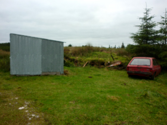
on to a rough stony track which wound up the hillside to a fairly level crest and an area of extensive moorland. On reaching an old tin shed and a couple of abandoned cars (see photo) at 
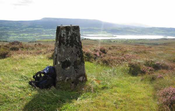
C (H12813 42327) I turned off the track to the left and struck out SE across the moorland in the direction of the still unseen summit. I found the going very heavy over large tussocky clumps of grass and heather making for slower progress than I would have liked. Near the trig pillar I passed the old wireless mast mentioned by three5four0 in his comments. The walk out over the moorland to the top at 
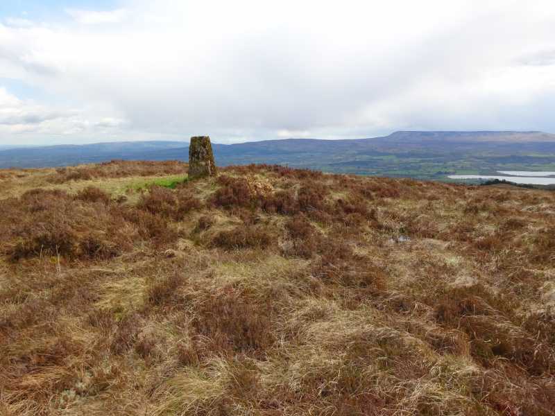
D (H13856 41767) was just over 1k and some 2.2k from my starting point. Madfrankies photo and description of the views indicate what is to be expected on a visit to this hill. While I note his view that it may only attract the committed summiteer this alternative and much shorter route to the top, in both time and distance, might facilitate someone wishing to do several walks in the area on the same day . I returned by way of ascent a total distance of 4.4k (2k of which was heavy going) and completed in just over an hour. Linkback: mountainviews.ie/summit/843/comment/6119/
Read Less
Read More

three5four0 on Belmore Mountain
by three5four0 5 Jan 2010
Whilst Tullybrack lends its self to the noctivagant & ochlophobic, Belmore, its big sister, has been logged by 2 other walkers and with its larger area of boggy summit, with some bluffs, is best left to daylight wanderings.

There is just enough space at DooLtr (H103 426), to park a car (Boho to Mullylusty minor road) and still allow access through the gate to forestry vehicles (also sign posted as a walking route). The OSNI map sheet 17, marks the forestry tracks accurately so there is no need for a detailed description, other than make your way to where the track ends at E (H131 417). From here follow a faint track through the trees, over a ditch and fence onto the open hillside. Cross the bog, with some deep heather in places, to the summit, there is a small radio mast not shown on the map a short distance from the trig point. Linkback: mountainviews.ie/summit/843/comment/4324/
Read Less
Read More

an alternative route for belmore
by Fergalh 30 Nov 2013
an alternative route park at Mullaghdun rc church walk up hill at T junction continue up concrete road for 2 km continuing straight all the way, cross over 5 gates when path ends head for abandoned house behind house is track to top of ridge trig point is 500 metres away around 6 km or just under two hours hike... Linkback: mountainviews.ie/summit/843/comment/15274/
Read Less
Read More

            MountainViews.ie picture about Belmore Mountain (<em>Sliabh an Bhéil Mhóir</em>)
Moorland & summit views
by TommyMc 30 Apr 2018
Visited Belmore Mountain on a mostly sunny day in April 2018. Followed Harry Goodman's 2010 instructions which still hold true. The first 1.2km or so on the rough stony track to reach the tin shed at C (H12813 42327) was easy, while the remaining 1km or so over spongy and largely featureless moorland was more of a challenge, but overall not unpleasant.

I could find no remaining sign of the old wireless mast near the trig pillar. Upon reaching the summit, lovely views open up all around, particularly towards Lough Macnean, Cuilcagh and Benaughlin.

From Boho village proper, follow the signs for Boho Caves/Pollnagollum and stay on the road uphill at the caves, until you reach Harry's starting point near a farmhouse, at B (H12663 42896), where there is a parking space. Linkback: mountainviews.ie/summit/843/comment/19911/
Read Less
Read More
EDIT Point of Interest
text
Videos

Recent Contributions
x
Conditions and Info
Use of MountainViews is governed by conditions and a privacy policy.
Read general information about the site.
Opinions in material here are not necessarily endorsed by MountainViews.
Hillwalking is a risk sport. Information in comments, walks, shared GPS tracks or about starting places may not be accurate for example as regards safety or access permission. You are responsible for your safety and your permission to walk.
See the credits and list definitions.

OSi logo
OSNI/LPS logo
Open Street Map
(Various variations used.)
British summit data courtesy:
Database of British & Irish Hills