Cookies.
This website uses cookies, which are small text files that the website puts on your device to facilitate operation. Cookies help us provide a better service to you. They are used to track general user traffic information and to help the website function properly.
Features
Nearby features appear when you click the map.
Declutter tracks on map.
Place Search
Video
X
Pub: by
Antrim Hills Area , Cen: Central Antrim Hills Subarea
Feature count in area: 27, all in Antrim, OSI/LPS Maps: 14, 15, 4, 5, 8, 9
Highest Place: Trostan 550m

Starting Places (3) in area Antrim Hills:
Donalds Carn, Rathlin Island Ferry Port, Whitehead Golf Club

Summits & other features in area Antrim Hills:
Cen: Central Antrim Hills: Carncormick 436m, Collin Top 429m, Crockalough 402m, Mid Hill 440m, Skerry Hill 459m, Slieveanorra 508m, Slievenahanaghan 418m, Soarns Hill 403m, Tievebulliagh 402m, Trostan 550m
Central Antrim Hills: Slievenanee 543m
N: North Antrim Hills: Carnanmore 379m, Croaghan 417m, Crockaneel 403m, Cross Slieve 206m, Knocklayd 514m, Lannimore Hill 207m
N: Rathlin Island: Kilpatrick (Rathlin Island) 134m
S: Islandmagee: Donalds Carn 141m, Muldersleigh Hill 131m
S: South Antrim Hills: Agnew's Hill 474m, Big Collin 353m, Black Hill 381m, Carnearny 319m, Douglas Top 402m, Slemish 437.9m
W: West Antrim: Long Mountain 215m

Note: this list of places may include island features such as summits, but not islands as such.
Rating graphic.
Crockalough, 402m Hill Cnoc an Locha A name in Irish,
Place Rating ..
, Antrim County in Ulster province, in Carn Lists, Crockalough is the 935th highest place in Ireland.
Grid Reference D20779 23423, OS 1:50k mapsheet 9
Place visited by: 41 members, recently by: PPruzina, Paddym99, garybuz, ElaineM76, Colin Murphy, pdtempan, Andy1287, Kilcoobin, Aongus, LorraineG60, MichaelG55, eamonoc, whoRya, Bernieor, madfrankie
I visited this place: NO (You need to be a logged-in member for this.)
Longitude: -6.111363, Latitude: 55.0435, Easting: 320779, Northing: 423423, Prominence: 77m,  Isolation: 2.8km
ITM: 720701 923406
Bedrock type: Olivine basalt lava, (Lower Basalt Formation)

  Short or GPS IDs, 6 char: Crc402, 10 char: Crcklgh402

Linkback: https://mountainviews.ie/summit/817/
Gallery for Crockalough (Cnoc an Locha) and surrounds
Summary for Crockalough (Cnoc an Locha): Easy enough climb to nondescript summit.
Summary created by Colin Murphy 2022-11-28 12:40:36
            MountainViews.ie picture about Crockalough (<em>Cnoc an Locha</em>)
Picture: The eastern flank of Trostan seen from the summit area.
On starting point is from A (D19944 23284) where you see a low white sign reading Cloch Ghlas, and there is parking for a single car. Cross the road, hop a gate and fence and proceed up the grassy slope in a NE direction for approx 1km. The summit area is broad and a bit rougher than the ascent, boggy in parts with some peat hags, and the precise high point is difficult to ascertain although maps indicate it is towards the southern end. Good views all round. 50 minutes up and down.
Linkback: mountainviews.ie/summit/817/comment/5576/
Member Comments for Crockalough (Cnoc an Locha)
Comment create / edit display placeholder

            MountainViews.ie picture about Crockalough (<em>Cnoc an Locha</em>)
Picture: Looking east from Crockalough summit into Glenarriff
slemish on Crockalough
by slemish 12 May 2009
In glorious weather like today there's only one place I want to be and that's out on the hills. Today Crockalough was the hill of choice. I parked at the layby beside the Essathohan bridge (B (D191 217)). This is also a good parking spot if climbing neighbouring Trostan. Follow the road towards Cushendall from here for about half a mile until you are past the forest. Veer off the road here, keeping the fence to your right as you ascend. The summit of Crockalough can be seen straight ahead. Not too steep a climb but boggy and tussocky just like the rest of the hills in this part of Antrim. Take care as there are many small burns hidden amongst the deep heather. Crockalough is quite flat on top with the small summit area sticking out. The 402m summit as shown on the OS map is unmarked on the ground. I wasn't convinced this was the actual highest point as an area about 200m to the north looked slightly higher. Plenty of peat hags and small pools of standing water to negotiate on top as well. Fine views however on a clear day like this, especially east into the vast glacial valley that is Glenarriff. Across the North Channel, Kintyre, Arran and Ailsa Craig were all clearly visible. Trostan and Slievenanee dominate the view to the west but Tievebulliagh, Slieveanorra and Knocklayd can also be seen. To the south a ridge of 400m+ summits marks the horizon - Collin Top, Mid Hill and Carncormick. The adventurous hiker might want to continue the route north-west to Lurigethan but not me as I was ready to head back to the car. I descended by the same route. Total trip about 1.5 hours. Linkback: mountainviews.ie/summit/817/comment/3761/
Read Less
Read More

            MountainViews.ie picture about Crockalough (<em>Cnoc an Locha</em>)
Picture: steep slopes rising from Glenariff
gerrym on Crockalough
by gerrym 26 Dec 2008
Crockalough is the highest point of the majestic upland plateau separating two of the famous Glens of Antrim - Glenariff and Glenballyemon. This visit to the plateau starts in the village of Waterfoot, parking in the handy carpark next to the beach (C (D243 255)). Return to the main street and head for the bridge over the Glenariff river, passing a number of pubs and taking in the smell of burning turf. Turn right to follow the coast road as it skirts the sandy beach of Red Bay and take the narrow road heading uphill at D (D243 259).

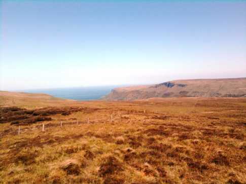
This is a steep narrow lane which quickly increases available views over the Irish sea, past redbay pier to the Mull of Kintyre, Ailsa Criag and the Isle of Man. Turn left at the end of this lane and follow the road uphill - just after the brow take a concrete farm lane to the left at E (D235 262), heading towards a noticeble mobile phone mast. Take a stone lane to the right, which greens and climbs to a gate leading to open hillside. Negotiate a maze of high gorse to to find short cropped grass reaching to the plateau above. The views continue to widen and deepen with height. Keep to the right of the headland to pick up a fence leading steeply uphill, cross a stile and a zig zag track brings the plateau in 45 mins with 1,200 ft of climbing.

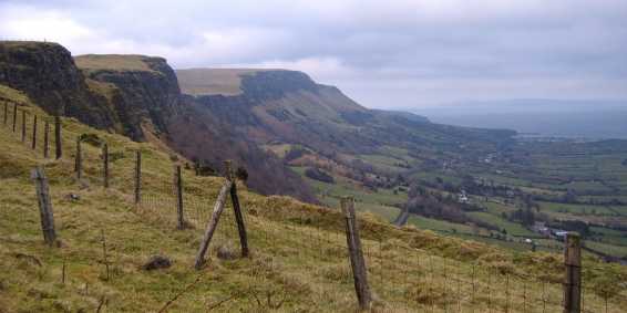
An old stone wall runs along the spine of the plateau here, with sharp posts protruding, almost as if waiting for the heads of those who would defy the local chieftains. The higher Antrim hills to the N come into clear view. The walk continues on the more dramatic S side of the plateau, along the steep slopes rising from the Queen of the Glens - Glenariff. This has to be one of the best examples of a U shaped glaciated valley in the country, with lush green farmland hemmed in by dramatically steep slopes on either side. A stream is reached (F (D220 234)) as it tumbles down into a waterfall and was just made to stop for a bite to eat. Continue to follow the edge of the escarpment as the valley below narrows to another stream (G (D218 224)). Follow this stream back into the plateau.

The stream heads for the low rise over 1 km away that is the top of Crockalough. This is over more difficult ground at times as head for the S end of the rise. Along the top there are peat hags and water to avoid. There are two distinctive little points along this top that showed 405m on my GPS so take your pick. The return is a drop and walk along the N side of the plateau which is not as inspiring. A number of dropping fencelines bar the way and my trousers bear the scars. the descent off is as the ascent, with the tide now out making the beach more picturesque.

A walk of just over 10 miles which took nearly three hours. Great scenery and presence, even on a dull day with a biting easterly wind. Saw a couple of other walkers but that is certainly the exception along here. Linkback: mountainviews.ie/summit/817/comment/3487/
Read Less
Read More

2nd Jan 2010
by Daithi2004 27 Apr 2010
2/01/2010. Brillaint day weatherwise. We parked at a small unofficial layby (H (D222 257) approx) Followed a track up onto the cliff edge of Lurigethan and walk along the edge/ridge towards Crockalough. As we go towards Crockalough, the snow got deep. It was gradual climb. Ended up at the road juntion (I (D198 230)) With fantastic views a round you. Brilliant Day Linkback: mountainviews.ie/summit/817/comment/4666/
Read Less
Read More
EDIT Point of Interest
text
Videos


Recent Contributions
x
Conditions and Info
Use of MountainViews is governed by conditions and a privacy policy.
Read general information about the site.
Opinions in material here are not necessarily endorsed by MountainViews.
Hillwalking is a risk sport. Information in comments, walks, shared GPS tracks or about starting places may not be accurate for example as regards safety or access permission. You are responsible for your safety and your permission to walk.
See the credits and list definitions.

OSi logo
OSNI/LPS logo
Open Street Map
(Various variations used.)
British summit data courtesy:
Database of British & Irish Hills