Members and Supporters, the MountainViews Committee requests your help to meet the costs of the website and of other activities such as insured events or publications.
Feature count in area: 31, by county: Leitrim: 22, Sligo: 10, of which 1 is in both Sligo and Leitrim,
OSI/LPS Maps: 16, 17, 25, 26
Highest Place: Truskmore 647m
Starting Places (22) in area Dartry Mountains: Aghavoghil Middle, Arroo Trail CP, Ballaghnatrillick, Ballintrillick Forest, Barrs East, Castletown, Crumpaun, Curraghan Road, Dough Mountain NW, Dough Mountain West, Drumcliff River Road, Eagles Rock, Edenbaun, Glencar Waterfall, Gleniff Horseshoe Road, Lough Cloonaquin North, Luke's Bridge, Mountain Wood, Poulveha River, Thur East, Tormore Car Park, Truskmore Transmitter Entrance
Summits & other features in area Dartry Mountains: N: Truskmore: Gortnagarn 445m, Tievebaun 611m, Truskmore 647m, Truskmore SE Cairn 631m NE: Arroo Keeloges: Aganny Top 482m, Aghalateeve 432m, Agow Top 423m, Arroo Mountain 523m, Conwal North 421m, Crocknagapple 372m, Keeloges 452m NW: Benbulbin: Annacoona Top 597m, Benbulbin 526m, Benwiskin 514m, Benwiskin South Top 508m, Kings Mountain 462m SE: Manorhamilton Hills: Ballaghnabehy Top 413m, Benbo 415m, Dough Mountain 462m, Lackagh Mountain 449m, Larkfield 305m, Naweeloge Top 441m, Thur Mountain 442m SW: Castlegal Hills: Copes Mountain 452m, Crockauns 463m, Hangmans Hill 400m, Keelogyboy Mountain 438m, Keelogyboy Mountain Far East Top 418m, Keelogyboy Mountain NE Top 435m, Keelogyboy Mountain SW Top 417m, Leean Mountain 417m
Note: this list of places may include island features such as summits, but not
islands as such.
Keelogyboy Mountain Far East Top, 418mHill Sliabh na gCaológ Buí (mullach i gcéin thoir) A name in Irish,
Place Rating ..
For origin of name, see Keelogyboy Mountain., Leitrim County in Connacht province, in Carn Lists, Keelogyboy Mountain Far East Top is the 860th highest place in Ireland.
Grid Reference G78617 38694,
OS 1:50k mapsheet 16 Place visited by: 48members, recently by: Carolyn105, abeach, melohara, noucamp, finkey86, magnumpig, Wilderness, glenlecky, dr_banuska, Wildrover, supersullivan, conormcbandon, markmjcampion, Hilldweller, marymac
I visited this place: NO (You need to be a logged-in member for this.)
Longitude: -8.329336, Latitude: 54.296857, Easting: 178617, Northing: 338694,
Prominence: 93m, Isolation: 1.2km ITM: 578561 838726 Bedrock type: Dark fine-grained cherty limestone, (Dartry Limestone Formation) Notes on name: Previously Sramore 1 in MV.
Short or GPS IDs, 6 char: Klg418, 10 char: KlgybyM418 Linkback: https://mountainviews.ie/summit/742/
Gallery for Keelogyboy Mountain Far East Top (Sliabh na gCaológ Buí (mullach i gcéin thoir)) and surrounds
Summary
for Keelogyboy Mountain Far East Top (Sliabh na gCaológ Buí (mullach i gcéin thoir)):
Ships prow sailing south with views.
Summary created by wicklore, simon3
2010-07-10 21:14:09
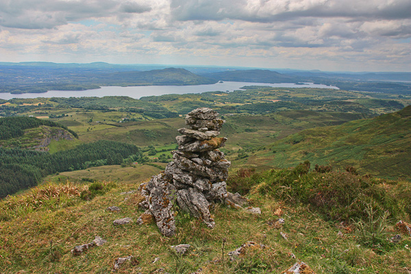
Picture: Summit cairn and views of Lough Gill.
Keelogyboy Far East is a fairly narrow NS ridge with the steep sides so characteristic of the limestone of the area. There's great views of Lough Gill and the wooded Doons to the south.
One way of reaching it is from the east and Leann Mountain via the northern slopes of the low hill of Fawnion. It is also possible to park at Edenbaun (G7668 4012) and follow a farm track into the valley. Head to the right of Hangman's Hill and contour around Keelogyboy Mountain NE Top. There is a sharp pull up to Keelogyboy Far E Top, and you shouldn't go too far before heading up as the slopes become cliffs further south.
The South and SW of this summit is a serious cliff. The top is covered in heather with a track leading from the north to the highest point towards the south, near which there is a substantial, narrow cairn.
This mountain is easy to recognise because of its shape. A good place to start is at Doon Lough car park at A (G794 363). From here walk down the R278 towards Sligo and take the second country road on your right which begins at B (G786 362). This road will take you straight up to the Sramore col to the west side of Keelogyboy Far E. MOST OF THE WEST SIDE OF KEELOGYBOY FAR E HAS A SHEER CLIFF SO IT CANNOT BE CLIMBED FROM THIS SIDE. Contour round to the north side or even the east side and you will find safer ways up. Linkback: mountainviews.ie/summit/742/comment/19897/
Use of MountainViews is governed by conditions and a privacy policy.
Read general information about the site. Opinions in material here are not necessarily endorsed by MountainViews.
Hillwalking is a risk sport. Information in comments, walks, shared GPS tracks or about starting places may
not be accurate for example as regards safety or access permission. You are responsible for your safety and your permission to walk.
See the credits and list definitions.


 Our Facebook page.