Members and Supporters, the MountainViews Committee requests your help to meet the costs of the website and of other activities such as insured events or publications.
Feature count in area: 12, all in Louth,
OSI/LPS Maps: 29, 36, EW-CLY
Highest Place: Slieve Foye 587m
Starting Places (24) in area Cooley Mountains: Annaloughan Loop Walk CP, Beck's Lane, Cadger's Bridge, Carlingford Car Park, Carlingford Greenway, Clermont Junction, Clermont Pass Bridge, Corna Mucklagh House, Deserted Village, Feede South, Flagstaff Viewing Point, Foxes Rock SW, Glenmore Tain Way, Grange Cross, Long Woman's Grave, Lower Faughil Road, Slieve Foye Viewing Point, Slievefoy Forest CP, Slievenagloch N, Spellickanee Mid, St Oliver's Park, The Ben Rock, The Lumpers, Two Mile River CP
Summits & other features in area Cooley Mountains: N: Cooley North: Anglesey Mountain 421m, Carnavaddy 475m, Clermont 444m, Clermont Carn 510m, Clermont Carn NE Top 448m S: Cooley South: Barnavave 350m, Slieve Foye 587m, Slieve Foye North-West Top 548.1m, Slievenaglogh 310m, The Eagles Rock 530m, The Foxes Rock 404m, The Ravens Rock 457m
Note: this list of places may include island features such as summits, but not
islands as such.
Anglesey Mountain, 421mHill
Place Rating ..
, Louth County in Leinster province, in no lists, Anglesey Mountain is the 845th highest place in Ireland. Anglesey Mountain is the most northerly summit in the Cooley Mountains area.
Grid Reference J10556 17770,
OS 1:50k mapsheet 29 Place visited by: 100members, recently by: TommyMc, Carolineswalsh, Jai-mckinney, Oscar-mckinney, MickM45, newpark-cc, archmeister, Andy1287, Reeks2011, Kirsty, Carolyn105, atlantic73, PPruzina, trostanite, dregishjake
I visited this place: NO (You need to be a logged-in member for this.)
Longitude: -6.310085, Latitude: 54.097719, Easting: 310556, Northing: 317770,
Prominence: 26m, Isolation: 1km ITM: 710532 817835 Bedrock type: Microgranite with granophyric texture, (Granophyre) Notes on name: Called after the Marquess of Anglesea, who till the middle of the last century [i.e. 19th century] owned it. [Stubbs]
Short or GPS IDs, 6 char: AnglMn, 10 char: AnglsyMntn Linkback: https://mountainviews.ie/summit/699/
Gallery for Anglesey Mountain and surrounds
Summary
for Anglesey Mountain :
Great Carlingford views from a so-so top
Summary created by Colin Murphy
2018-10-08 11:33:51
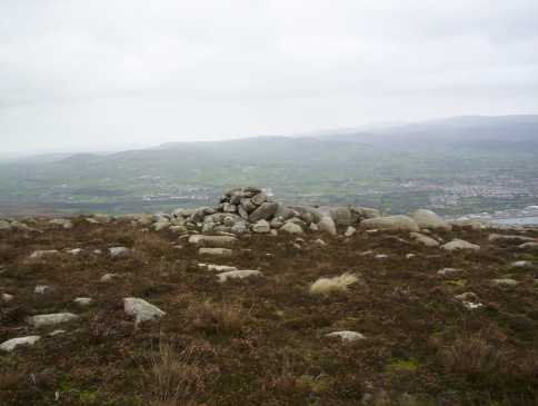
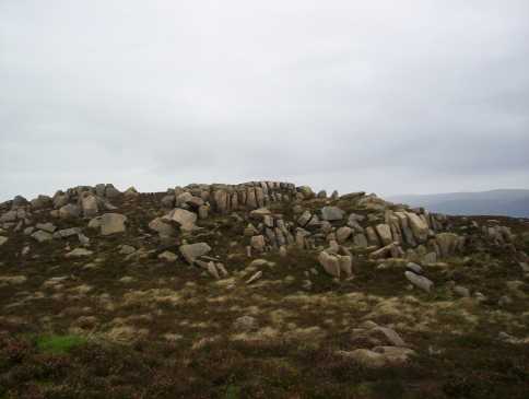
Picture: Summit cairn
There is enough space to park one car at A (J100 167), just on the edge of a wood around a sharp u-bend. Proceed north for 100m before turning NE up a gentle slope, although the terrain is treacherous - long heather, very uneven ground cut through with lots of trenches - it's a real slog. At B (J103 170) descend to the north to a col of sorts and then continue for about 700m up a gentle slope, and thankfully the terrain becomes easier to traverse. There is a false summit first, and then the actual high point about 200m beyond that, marked by a cairn. The summit area is littered with boulders and is quite interesting, but the mountain is nothing to write home about, although the views over Carlingford Lough are quite spectacular. 1 hour return trip in total.
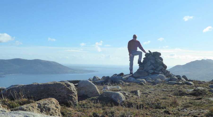
Picture: Even from the lower slopes there are great views across Carlingford Lough - as Susie found
dr_banuska on Anglesey Mountain
by dr_banuska
11 Jul 2009
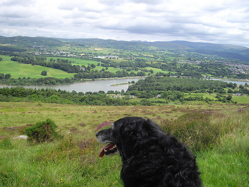
Myself and the dog climbed Anglesey as part of a 5 summit hike in the Cooleys (the other 4 being Clermont, Black Mountain NE Top, Clermont Cairn and Carnavaddy in that order). I parked at the same pub car park as eflanaga - thanks for the tip! Was a bit wary about leaving the car there for so long and not even buying one drink but I didn't have any problems. I followed the same route: uphill and around to the first crossroads, take right and uphill towards the Co. Armagh border. Just before the border, which is marked by a stream, there is a forest track on the left. I followed this and then after a short distance when the track curves round to the right, I crossed a wire fence and started making my way up across open hillside. As eflanaga says, there is a wall which I followed for a while until it and the forest curve off to the right (west). I found this mountain deceptively tough going I must say, maybe because it was the first summit of the day, but I kept thinking the summit was in sight only to find higher slopes kept emerging. The terrain is pretty tough though and I found it best to keep to my right as there was less undergrowth, until I met a wire fence that brought me pretty much to the summit. I actually didn't even spot the small cairn at first, and as others have said it's clear that a rocky outcrop a little beyond it is the true summit. The views are great from this hill: even from the lower slopes there are great views across Carlingford Lough towards Warrenpoint and the High Mournes beyond. As you progress upwards the views open out to include Slieve Foye and interesting views towards Camlough Mountain and the lower eastern hills of the Ring of Gullion, then Slieve Gullion itself and finally the surprisingly welcome sight of the transmitter on Clermont Cairn. I could even make out the Belfast hills and the distinctive profile of Slieve Gallion in the Sperrins, and maybe even a narrow slither of Lough Neagh. Anglesey was a nice start point for my multi-summit hike, only thing was there was a long road walk back to the car when I finally made it down from Carnavaddy. Linkback: mountainviews.ie/summit/699/comment/3921/
Read Less
Read More
Picture: Anglesey Mtn Cairn with Warrenpoint in background
by eflanaga
30 Apr 2023
Started this linear walk of the Cooley ridge from car park at pub right on the border at Cornamucklagh. CorMuc H (J12050 19107). Walked up road for about 1km and around to cross-road taking right turn uphill in the direction of Flagstaff so as to start the ascent from the start of the forested area. Following along its boundary wall, as much of the eastern side of the hill around this area is covered in heavy undergrowth. Made good speed up to point where wall turns west. From here broke across the open hillside and continued to make my way steadily towards the summit. The summit area is quite broad and there is a small cairn at C (J10370 17688). However, a rocky area D (J10567 17781) about 40m south in direct line with the masts on Clermont Cairn appears to me to be a higher point. GPS reading here was 429m Linkback: mountainviews.ie/summit/699/comment/2895/
Read Less
Read More
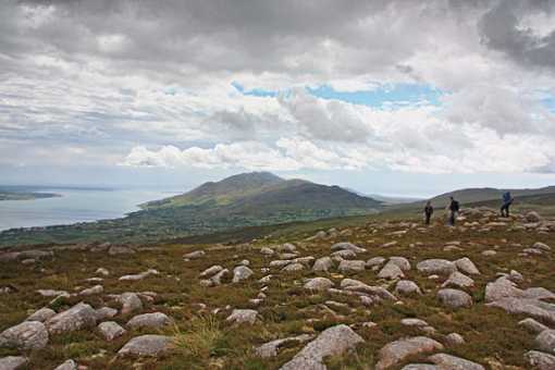
Picture: East from Anglesey Mountain, Cooley Mountains.
simon3 on Anglesey Mountain
by simon3
7 Jul 2008
Claude Wall [Mountaineering in Ireland] describes the "Cuailgne Mountains" as follows: "This grand little range extends for about ten miles along the southern shore of the Newry river and Carlingford Lough". His walk starts on Anglesey Mountain and continues to Carlingford town (or actually beyond to Barnanave and Grange 312m). We can agree with him that "There is no real climbing in this area, the scene of much of the epic of the Tain Bo Cuailgne and rich in prehistoric monuments."
Most of the route has been described in walk 75, "Traverse of the Cooleys" maintained by ahendroff. Our photo shows the small cairned summit and stone littered area nearby. Highest and central on the skyline is Slieve Foye with the ridge containing the Ravens Rock and the Foxes Rock stretching towards us and lowering to the road at Windy Gap. The people are standing around the summit of Anglesey Mountain, such as it is. Over their heads on the skyline is Carrickrawor also part of the traverse of the Cooleys.
There are also views towards Rostrevor and Warrenpoint which are hinted at by eflanaga's pic. The sky was pretty dramatic that day which was some compensation for the drenching it gave us earlier. Linkback: mountainviews.ie/summit/699/comment/3202/
Read Less
Read More
Picture: Anglesey's true summit?
eflanaga on Anglesey Mountain
by eflanaga
10 Nov 2007
Finding the true summit on Anglesey is difficult. The cairn pictured above appears to be lower than the area in this picture. Standing on the highest rock in this outcrop there appears to be little doubt that it is higher than the cairn and other contenders for the title. Linkback: mountainviews.ie/summit/699/comment/2897/
Read Less
Read More
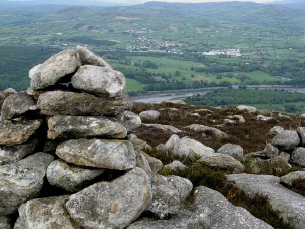
Picture: The cairn just NE of the summit and Narrow Water in background
pdtempan on Anglesey Mountain
by pdtempan
3 Jun 2009
(Continued from Black Mountain NE Top) Shortly after NE Top the path came to an end and the heather-bashing began. I made for a fence junction and then turned NE towards Anglesey Mountain. There was a path again, even if rather wet, which led towards a gate. Having crossed the gate, Anglesey Mountain lay directly along the line of a fence, but the heather was fairly high and no path followed the fence. I followed a vague track that branched off at about 20 degrees. About 100m later, it turned back towards the fence, and then, to my bemusement and amusement, the track went under the fence! So the fence had been built recently over the track. I followed the fence as best I could to the summit, where, once again, there were excellent views over Carlingford Lough and Newry River. Linkback: mountainviews.ie/summit/699/comment/3807/
Use of MountainViews is governed by conditions and a privacy policy.
Read general information about the site. Opinions in material here are not necessarily endorsed by MountainViews.
Hillwalking is a risk sport. Information in comments, walks, shared GPS tracks or about starting places may
not be accurate for example as regards safety or access permission. You are responsible for your safety and your permission to walk.
See the credits and list definitions.


 Our Facebook page.