This website uses cookies, which are small text files that the website puts on your device to facilitate operation. Cookies help us provide a better service to you. They are used to track general user traffic information and to help the website function properly.
Feature count in area: 27, all in Galway,
OSI/LPS Maps: 37, 38, 44, 45, EW-CON
Highest Place: Binn idir an dá Log 702m
Starting Places (42) in area Maamturks: An Móinín Mór, Bealanabrack River Tributary, Bundorragha Estuary Cross, Cannaclossaun, Carraig Bar, Connemara Mountain Hostel, Delphi Resort, Dernasliggaun, Drehidanookera Bridge, Failmore River, Fee Lough SW, Glashmore Bridge, Glencraff Road End, Gleninagh River, Gowlaunlee Lake, Illaunroe South, Killary Boat Tour Pier W, Knocknafaughy SW, Kylemore River, Leenane, Leenane Hotel, unuseableLeenane R336, Lehanagh Lough N, Lehanagh Lough SE, Lough Fee East, Lough Nacarrigeen S, Lough Shindilla S, Maum Bridge Road Lower, Maum Bridge Road Mid, Maum Bridge Road Upper, Maumwee Lough, Nambrackkeagh Lough, Oorid Lough, Owenwee River, Pas Mám Éan CP, Rinavore East, Rinavore SW, Shanvally, Tawnabeg Lough North, Tooreennacoona River, Western Way Cnoc na hUilleann, Western Way Inagh Cottages
Summits & other features in area Maamturks: N: Leenaun: Maumturkmore 488m, Búcán 550m, Leenaun Hill 618m, Leenaun Hill Far North-West Top 556m, Lettershanbally 324m, Meall Cheo 578m, Taobh Dubh 422m N: Maumturks N Cen: Barrlugrevagh 558m, Letterbreckaun 667m, Letterbreckaun NE Top 603m, Knocknahillion 607m, Knocknahillion North Top 541m, Cúlóg 435m S: Maumturks S Cen: Binn Chaonaigh 633.5m, Binn idir an dá Log 702m, Binn idir an dá Log SE Top 659.3m, Binn Mhairg 612.4m, Knocknagur 310m S: Maumturks South: Binn Mhór 660.6m, Binn Mhór NE Top 641.2m, Binn Mhor West Top 595.8m, Binn Mhor East Top 631.3m, Lissoughter 401m, Corcogemore 610.1m, Mullach Glas NE Top 432m, Lackavrea 396m, Mullach Glas 621.3m
Note: this list of places may include island features such as summits, but not
islands as such.
Cúlóg, 435mHill
Place Rating ..
(Ir. Cúlóg [TR], 'little nook'), Anacair, Galway County in Connacht province, in Carn Lists, Cúlóg is the 790th highest place in Ireland.
Grid Reference L88903 54283,
OS 1:50k mapsheet 37 Place visited by: 37members, recently by: Wilderness, paulbrown, Haulie, scapania, elizauna, GSheehy, PPruzina, markmjcampion, eamonoc, Fergalh, patmoran, PatHargan, billh999, JohnAshton, trevorf
I visited this place: NO (You need to be a logged-in member for this.)
Short or GPS IDs, 6 char: Cúlóg, 10 char: Cúlóg Linkback: https://mountainviews.ie/summit/675/
Gallery for Cúlóg and surrounds
Summary
for Cúlóg :
A tough little outlier of the main Maamturks ridge
Summary created by wicklore
2013-08-19 14:37:14
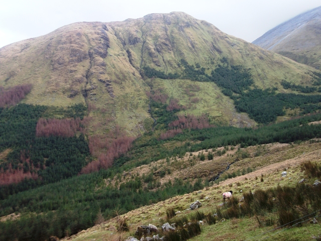
Picture: Cùlòg from the north
Cùlòg can be accessed from A (L87901 55560). The starting point is in the Glenlosh Valley, which is privately owned. It is advised to seek permission from the landowners who live in the last house at the end of the valley.
Starting at one of the valleys holiday cottages, it's a pleasant walk along a good (but wet) track initially, then following the banks of a rushing mountain stream. A steep uphill pull then brings you across an unspoilt heathery plateau to the high point. There are great views over to the nearby main Maamturks. The unspoilt nature of this summit means there are no tracks through the heather on the last several hundred metres of the walk across the top.
For those already up on the main Maamturks ridge, an approach can be made from Loch Mhám Ochoige. From the lake descend north-eastward to the col between Loch Mhám Ochoige and Cúlóg, and head up to Cùlòg from there.
Here is a link to a gps track for a 7km return walk from the Glenlosh Valley to Cùlòg that avoids very steep ground to the west and north: http://mountainviews.ie/track/1331/
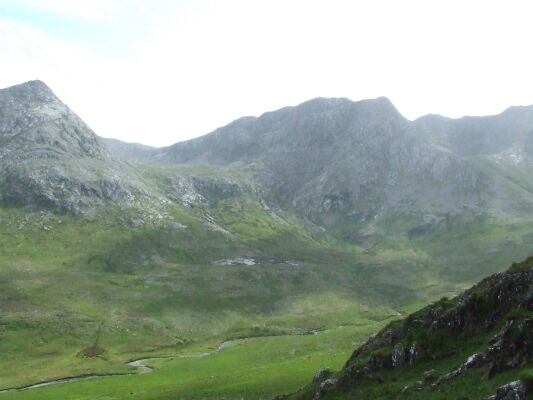
Picture: Binn Chaoignah,Binn idir an dá Log and Failmore valley
HimiWack on Cúlóg
by HimiWack
12 Jul 2009
(continuation from Binn idir an dá Log). Next destination to reach was Loch Mhám Ochoige. Going north-westward i could see the lake soon. It´s a little bit difficult to find the descend to the lake because there are some steep crags on the way. By the lake i turned north-eastward descendig to the col between Loch Mhám Ochoige and Cúlóg. A last climb on a grassy hillside brought me to the top of Cúlóg. From the top it is an easy walk on the ridge eastward. The last part of my way i followed the Failmore river to the little road where my car was parked. The time i took for the Failmore horseshoe was around 6,5 hrs Linkback: mountainviews.ie/summit/675/comment/3917/
Read Less
Read More
Picture: Some Maamturks From Culog
Nice views of main Maamturks
by markwallace
22 Sep 2015
Arrived at Culog after a tricky descent from Binn Idir an Da Log, a little too steep to be comfortable walking, but doable. I assumed Culog would be little frequented, but there are traces of a path along the long summit area, so maybe not. Great views to the main Maamturks from this minor summit, also down into Glenglosh, Maam Valley, and so on. Photo shows Binn Idir an Da Log SE top (centre) and Binn Idir an Da Log (right) from Culog. Viewed from around Culog, it seems the name Binn Idir etc. must surely refer to the SE top, which is genuinely "between two hollows", unlike its parent peak.
From Culog the horseshoe walk continues onto Knocknagur, and then steeply down through many crags and crossing a fence onto the very, very quiet road. Despite the modest heights of these hills, this return leg of the Gleann Fada (aka Failmore) horseshoe is pretty hard walking. Linkback: mountainviews.ie/summit/675/comment/18324/
Use of MountainViews is governed by conditions and a privacy policy.
Read general information about the site. Opinions in material here are not necessarily endorsed by MountainViews.
Hillwalking is a risk sport. Information in comments, walks, shared GPS tracks or about starting places may
not be accurate for example as regards safety or access permission. You are responsible for your safety and your permission to walk.
See the credits and list definitions.


 Our Facebook page.