Cookies.
This website uses cookies, which are small text files that the website puts on your device to facilitate operation. Cookies help us provide a better service to you. They are used to track general user traffic information and to help the website function properly.
Features
Nearby features appear when you click the map.
Declutter tracks on map.
Place Search
Video
X
Pub: by
Antrim Hills Area , S: South Antrim Hills Subarea
Feature count in area: 27, all in Antrim, OSI/LPS Maps: 14, 15, 4, 5, 8, 9
Highest Place: Trostan 550m

Starting Places (3) in area Antrim Hills:
Donalds Carn, Rathlin Island Ferry Port, Whitehead Golf Club

Summits & other features in area Antrim Hills:
Cen: Central Antrim Hills: Carncormick 436m, Collin Top 429m, Crockalough 402m, Mid Hill 440m, Skerry Hill 459m, Slieveanorra 508m, Slievenahanaghan 418m, Soarns Hill 403m, Tievebulliagh 402m, Trostan 550m
Central Antrim Hills: Slievenanee 543m
N: North Antrim Hills: Carnanmore 379m, Croaghan 417m, Crockaneel 403m, Cross Slieve 206m, Knocklayd 514m, Lannimore Hill 207m
N: Rathlin Island: Kilpatrick (Rathlin Island) 134m
S: Islandmagee: Donalds Carn 141m, Muldersleigh Hill 131m
S: South Antrim Hills: Agnew's Hill 474m, Big Collin 353m, Black Hill 381m, Carnearny 319m, Douglas Top 402m, Slemish 437.9m
W: West Antrim: Long Mountain 215m

Note: this list of places may include island features such as summits, but not islands as such.
Rating graphic.
Slemish, 437.9m Hill Sliabh Mis A name in Irish,
Place Rating ..
(Ir. Sliabh Mis [logainm.ie], 'mountain of Mis'), Antrim County in Ulster province, in Carn Lists, Slemish is the 781st highest place in Ireland.
Grid Reference D22161 05397, OS 1:50k mapsheet 9
Place visited by: 167 members, recently by: sprog, cmcv10, Colin Murphy, conormcbandon, Tricia-Mulligan, headspace, Paddym99, Sperrinwalker, garybuz, annem, Carolyn105, ElaineM76, Dave68, Hoverla, trostanite
I visited this place: NO (You need to be a logged-in member for this.)
Longitude: -6.097413, Latitude: 54.88134, Easting: 322162, Northing: 405398, Prominence: 152m,  Isolation: 3.4km, Has trig pillar
ITM: 722083 905385
Bedrock type: Dolerite & gabbro, (Dolerite & gabbro)
Notes on name: Slemish is remarkable for its pudding-like shape, which makes it unmistakable from any angle. It is particulary prominent seen from the west near Ballymena. This shape is due to its origin as a volcanic plug. According to tradition, it was on Slemish that St. Patrick spent six bleak years as a slave herding sheep and swine. Patrick was captured in Britain at the age of 16 and sold as a slave to an Irish chief named Milchú.
  Short or GPS IDs, 6 char: Slmsh, 10 char: Slemish

Linkback: https://mountainviews.ie/summit/667/
Gallery for Slemish (Sliabh Mis) and surrounds
Summary for Slemish (Sliabh Mis): Well worth a visit
Summary created by wicklore 2011-05-14 15:47:32
            MountainViews.ie picture about Slemish (<em>Sliabh Mis</em>)
Picture: Rising proudly above the land
Slemish is a striking hill, appearing as a sudden lump sticking out of the surrounding land. It is very popular with Pilgrims on St Patrick’s Day, and can also be busy on most weekends. Starting at A (D217 057) there is a track to the summit that will take about 20 – 25 minutes. The track is steep and muddy in places and would require care on icy days. Because of land ownership, this is the only approved route to the summit. There is some very steep ground to the north of the summit that would pose danger to the unsuspecting rambler. However stick to the track and there won’t be an issue.
Linkback: mountainviews.ie/summit/667/comment/5426/
Member Comments for Slemish (Sliabh Mis)
Comment create / edit display placeholder

            MountainViews.ie picture about Slemish (<em>Sliabh Mis</em>)
Picture: Looking north from Slemish summit towards Slievenanee and Trostan
slemish on Slemish
by slemish 26 Mar 2009
A bright, dry and clear afternoon in late March - perfect weather I felt to revisit an old friend, although I hadn't climbed it in about 8 years. I deliberately waited until the week after St Patrick's day to enjoy Slemish in its full glory. I was glad to see when I reached the car park there were no other cars there so I had the mountain to myself. Sadly there were a few remnants from the previous week's visitors littering the route - I saw 1 beer can and 2 water bottles which I removed from the mountainside.

I climbed the slightly more difficult NW slope. The going was good, the recent dry weather helping conditions underfoot. The ascent was pretty straightforward, though perhaps a little steeper than I remember. The summit can't be seen on the approach and is reached rather suddenly - the first thing you notice is the wind picks up even more than normal, then the steep slope quickly opens out onto the summit area. I can confirm that there was once a trig pillar on the summit - nowadays a large wooden cross marks the point.

Views? You bet! Although Slemish is only 437m high, its relative isolation from other hills means there are extensive views over the Braid valley and the higher Antrim hills to the north (Slievenanee and Trostan in particular clearly visible), then east to to the North Channel, Agnew's Hill and the Belfast hills to the south and Lough Neagh and the Sperrins to the west. I didn't stay long on the summit - the wind was biting hard so I quickly descended by the slightly easier SW slope.

Total trip up and down - approx 1 hour. A fairly easy but rewarding climb, Slemish is at its best on a good clear day when there's no-one else around. Linkback: mountainviews.ie/summit/667/comment/3680/
Read Less
Read More

            MountainViews.ie picture about Slemish (<em>Sliabh Mis</em>)
Picture: Iconic Hill
Ireland's Uluru?
by wicklore 15 Nov 2010
Slemish rises from the surrounding lowlands like an Irish Uluru and it strikes an impressive pose from any approach. Unfortunately its popularity means that it will never score highly in the wilderness or environment stakes, while private ownership in the area means that there is only one acceptable approach. However Slemish should be viewed as one of Ireland’s iconic hills and should be on the list of any hiker who walks in the North.

Slemish is a volcanic plug, which accounts for why it rises so suddenly from the land. Originally magma would have hardened within the vent of the volcano, and over subsequent aeons the outer volcano eroded away leaving this striking volcanic landform behind.
Slemish is reputedly where St Patrick tended sheep as an enslaved youth, and where he found God. The historians are startlingly precise about this period of his life – he was here from age 16 to 22! However others feel he spent this period of time in the West of Ireland so who knows? The hill is celebrated on St Patricks Day as many people make a Pilgrimage to its summit.

Slemish also has links to the 1798 Rebellion. The first major act of the Rebellion was an attack on Antrim town on 7 June that year led by Henry Joy McCracken. This failed, and for some weeks McCracken and his diminishing force were fugitives around Slemish before he was caught and hanged in July in Belfast. A well bearing his name stood on the southern slope of the hill for many years.

The approved track for Slemish, along with visitor facilities, starts at A (D217 057). A steep trail leads to the top in about 20 or 25 minutes. This trail can be wet and slippery, and would require caution in icy conditions. It is the kind of trail that would be easily manageable by regular walkers, whilst annual Pilgrims or those with children might find it a bit mucky and hard work. Slemish is a joy to behold, and the expansive views from the summit add to the quality of this hill.

The name Slemish probably derives from Sliabh Mish. Mish may in turn derive from the Gaelic ‘Mishasta’, meaning unsatisfactory or adverse. Well I can’t think of anything particularly unsatisfactory or adverse about this fine little hill! Linkback: mountainviews.ie/summit/667/comment/6161/
Read Less
Read More

            MountainViews.ie picture about Slemish (<em>Sliabh Mis</em>)
Picture: Slemish from the south
St Patricks Playground
by gerrym 28 Dec 2012
Slemish is very accessible, a drive steeply uphill through narrow lanes hemmed in by dry stone walls brings a carpark and visitor facilities at the height of 240m (A (D217 057)).

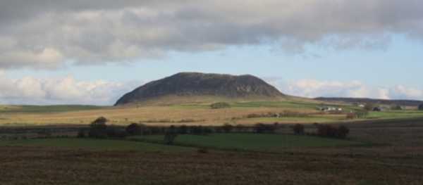
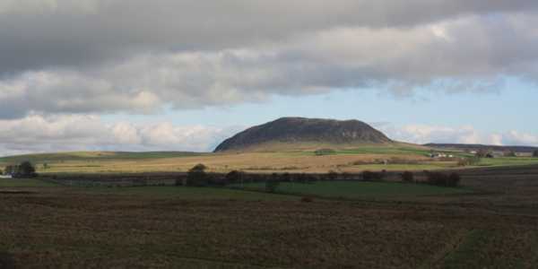
There are a number of informative boards on the history of the mountain - notably its volcanic origin. Slemish is steep and rocky and stands apart from most of the other Antrim Hills in this respect, looking like it would be more at home in Donegal or Connemara. Of course it is famous for its association with St. Patrick (the patron saint of this fair isle) who supposedly tended sheep on the hillside. On the 17th of March i am sure there would be an extra one or two feet making the climb to the top.

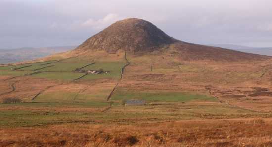
There is a marked track to the summit, this is private land and walkers are invited to stick to the track. A gate leads to some rough stone steps which pass between a few tortured hawthorn trees, grazed grass and further steps bring steeper, rockier ground. The ground was partially frozen and in any sort of wet weather care is needed on the rocks and narrow track as it climbs steeply. The N end of the summit is reached in 20 minutes and then it is an easy walk along the length of the top, though today the wind would have lifted paint.

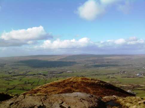
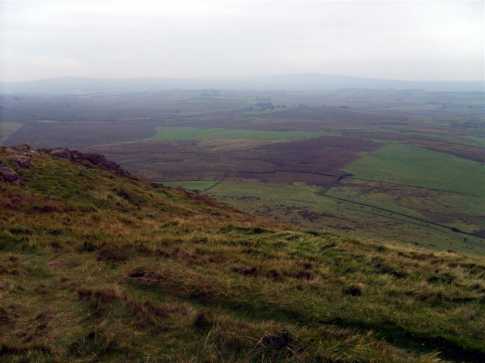
The views from the summit are wide and impressive - looking E to the Irish sea, N to the higher Antrim Hills, W to the lowlands and rising Sperrins and S to the Belfast HIlls. There used to be a trig pillar and i am sure that in my early years there were other various structures atop, but none these days.

The track drops of from the SW of the top to contour back to the carpark - dropped off the SE, some steep ground around big rocks. Then tracked NE towards Carrigin Hill (351m) (B (D231 058)). This was over varied but mostly good ground to reach the small cairn at the top in a further 20 minutes. There are nice views back over towards Slemish and over the expanses of rough moorland. It would be quite easy to return to the carpark from here, either around the N or S side of Slemish.Decided to extend the trip with a tramp across wet moorland to Douglas Top (C (D245 029)) some 3km to the S.

Met no one else throughout the walk until returning to the carpark when there were a couple of cars. A quick and easy walk, with lots of history attached which can be extended if desired. Linkback: mountainviews.ie/summit/667/comment/2928/
Read Less
Read More

three5four0 on Slemish
by three5four0 3 Oct 2008
Slemish, a short sharp ascent from the car park leads to the summit and quite extensive views of the Antrim hills. Alas, no Willie Drennan with his Lambeg to serenade the pilgrims, or at least the ones who made it out of the car park. Strange, the local farm hasn't opened a tea / souvenir shop to cater for the visitors, but stranger still is the council committee who thought putting the tourist information point in the toilet block was a good idea. Linkback: mountainviews.ie/summit/667/comment/3350/
Read Less
Read More

            MountainViews.ie picture about Slemish (<em>Sliabh Mis</em>)
Picture: View from near the summit
murphysw on Slemish
by murphysw 15 Sep 2008
When you tell people that you climb mountains, sometimes they dont seem interested in Kilimanjaro, Kosciuszko, or Everest Base Camp, but ask first if you've ever climbed Croagh Patrick. When I started getting asked about Slemish, I decided to get this one out of the way as it seems you must emulate that great mountaineer St. Patrick before you're taken seriously! From the car park there are waymarkers to follow though when you reach the steep west face of the mountain they seem to run out. There are a series of stiles you can cross which will bring you round to the south side of the mountain which is a much easier climb to the unmarked summit with its brilliant views. Interesting to note that a mountain that is associated with a saint should be '666'th highest in the country. Spooky! Linkback: mountainviews.ie/summit/667/comment/3319/
Read Less
Read More
EDIT Point of Interest
text
Videos


Recent Contributions
x
Conditions and Info
Use of MountainViews is governed by conditions and a privacy policy.
Read general information about the site.
Opinions in material here are not necessarily endorsed by MountainViews.
Hillwalking is a risk sport. Information in comments, walks, shared GPS tracks or about starting places may not be accurate for example as regards safety or access permission. You are responsible for your safety and your permission to walk.
See the credits and list definitions.

OSi logo
OSNI/LPS logo
Open Street Map
(Various variations used.)
British summit data courtesy:
Database of British & Irish Hills