Members and Supporters, the MountainViews Committee requests your help to meet the costs of the website and of other activities such as insured events or publications.
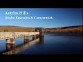
Antrim HillsArea, Cen: Central Antrim Hills
Subarea
Feature count in area: 27, all in Antrim,
OSI/LPS Maps: 14, 15, 4, 5, 8, 9
Highest Place: Trostan 550m
Starting Places (3) in area Antrim Hills: Donalds Carn, Rathlin Island Ferry Port, Whitehead Golf Club
Summits & other features in area Antrim Hills: Cen: Central Antrim Hills: Carncormick 436m, Collin Top 429m, Crockalough 402m, Mid Hill 440m, Skerry Hill 459m, Slieveanorra 508m, Slievenahanaghan 418m, Soarns Hill 403m, Tievebulliagh 402m, Trostan 550m Central Antrim Hills: Slievenanee 543m N: North Antrim Hills: Carnanmore 379m, Croaghan 417m, Crockaneel 403m, Cross Slieve 206m, Knocklayd 514m, Lannimore Hill 207m N: Rathlin Island: Kilpatrick (Rathlin Island) 134m S: Islandmagee: Donalds Carn 141m, Muldersleigh Hill 131m S: South Antrim Hills: Agnew's Hill 474m, Big Collin 353m, Black Hill 381m, Carnearny 319m, Douglas Top 402m, Slemish 437.9m W: West Antrim: Long Mountain 215m
Note: this list of places may include island features such as summits, but not
islands as such.
Mid Hill, 440mHill
Place Rating ..
, Antrim County in Ulster province, in Carn Lists, Mid Hill is the 773rd highest place in Ireland.
Grid Reference D20178 15662,
OS 1:50k mapsheet 9 Place visited by: 45members, recently by: trostanite, Colin Murphy, Paddym99, garybuz, Portosport, Kilcoobin, Andy1287, LorraineG60, MichaelG55, eamonoc, Fergalh, eejaymm, Ulsterpooka, PPruz, jimmyread
I visited this place: NO (You need to be a logged-in member for this.)
Short or GPS IDs, 6 char: MdH440, 10 char: Mid Hil440 Linkback: https://mountainviews.ie/summit/652/
Gallery for Mid Hill and surrounds
Summary
for Mid Hill :
Rough ascent through knee-high growth.
Summary created by Colin Murphy
2023-09-14 10:55:19
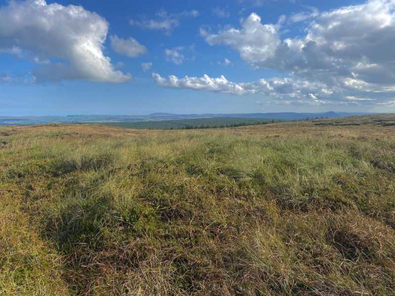
Picture: High point
Often done in conjunction with either Collin Top or Soarns Hill. One approach is to start from the Cargan Dam car park at A (D19239 17217) . Cross the dam and turn left, crossing two stiles and following a narrow trail along the south side of the reservoir, crossing over a small bridge to roughly B (D19759 17078), where you can strike out in a southerly direction towards the summit. The climb is gentle (roughly 140m over 2km) but the terrain is very rough and covered in long reeds, knee-high heather and equally long grass almost the whole way. The high point is an unmarked heathery mound.
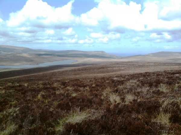
Picture: Looking north from the summit of Mid Hill
by slemish
14 May 2010
Why is Mid Hill called Mid Hill? I assume it is because when viewed from afar it is the central summit in the group of three between Glenravel and the Braid valley (the other two being Carncormick and Collin Top). I'm surprised there is only one other comment on Mid Hill as it is a very accessible hill with fabulous views on a clear day. I parked at the car park beside the Dungonnell reservoir (C (D192 172)). The summit area can be seen straight ahead. The ascent is fairly easy - just the odd small burn and fence to negotiate. Try to avoid the extensive patches of knee-deep heather as this will slow your progress somewhat. The 438m summit as shown on the OS map (D (D197 155)) is marked by a large fence post but this isn't actually the highest point of Mid Hill. About 500m east of here is the true highest point which is unmarked on the ground and according to the OS map is actually slightly higher than the 440m given by MV. Nevertheless anywhere on top of Mid Hill is good for views if you are lucky like me to have a very clear day like today. To the south-east is Soarns Hill and beyond that Agnew's Hill - then to the south lies Slemish with Big Collin and then Divis almost directly in line behind it. Coming west round past Lough Neagh and Carncormick you can see the Sperrins clearly - I could easily pick out Sawel peeping over the side of Mullaghaneany and to the right the ridge of hills from Carntogher to Benbradagh. Skerry Hill, Slievenanee and Trostan dominate the view to the north-east and the magnificent Glenariff valley to the north-west allows views out to sea and to Scotland. Great views and an easy climb - what could be better? I returned to the car by way of ascent - you can be up and down in less than an hour. Linkback: mountainviews.ie/summit/652/comment/4728/
Read Less
Read More
three5four0 on Mid Hill
by three5four0
7 Nov 2008
From Carncormick (see previous posts for Carncormick) we followed the fence north east through the usual soft, wet & heathery Co. Antrim terrain, crossing the fence just before the Red Sea. Then another fence (wire low or missing in a lot of sections), before climbing up hill passed a small deep flush with the chewed carcass of a sheep lying in it. Perhaps that black panther, the police failed to shoot on the north coast, is alive and well and roaming the Antrim hills. If it was, it would certainly spice up those late winter finishes!
From pt 438 there is a small dip then the final slope to Mid Hill, and as is usual in these parts, there are three small rises within the 440 contour line. Take your pick or do them all, the far rise has some rocks sticking out of the peat, so ideal for a lunch stop.
But what can you say about a hill whose views take in the land from Slemish to Trostan and the Sperrins to Arran, one to ponder while munching lunch on those rocks. See Collin Top for the continuation of this walk. Linkback: mountainviews.ie/summit/652/comment/3431/
Use of MountainViews is governed by conditions and a privacy policy.
Read general information about the site. Opinions in material here are not necessarily endorsed by MountainViews.
Hillwalking is a risk sport. Information in comments, walks, shared GPS tracks or about starting places may
not be accurate for example as regards safety or access permission. You are responsible for your safety and your permission to walk.
See the credits and list definitions.


 Our Facebook page.