Donation Request 2024

DONATE
Members and Supporters, the MountainViews Committee requests your help to meet the costs of the website and of other activities such as insured events or publications.
You do not have to be logged in to donate.
Features
Nearby features appear when you click the map.
Declutter tracks on map.
Place Search
Video
X
Pub: by
Croagh Patrick Area , N: North Ridge Subarea
Feature count in area: 12, all in Mayo, OSI/LPS Maps: 30, 31, 37, 38, CBE, CBW, MSW
Highest Place: Croagh Patrick 764m

Starting Places (19) in area Croagh Patrick:
Balloor, Ben Goram Road, Bracklagh, Carrowmore Hill South, Carrowrevagh Lough, Cregganbaun, Keelkill North, Kilgeever Wood, Killeennimat Burial Ground, Kinknock, Laghta Eighter, Laghta Eighter Hill NE, Murrisk Fishermans Monument, National Famine Memorial, Old Head, Paddy's Place, Prospect Lough Road, Sruhaunpollanoughty, St Patricks Church

Summits & other features in area Croagh Patrick:
N: North Ridge: Ben Goram 559m, Boheh Hill 219m, Croagh Patrick 764m, Crott Mountain 500m, Lugnademon 510m, Teevenacroaghy 487m
S: Owenmore: Carrowrevagh 210m, Knockakishaun 390m, Oughty Hill 333m
W: Louisburgh Hills: Balloor Hill 147m, Carrowmore Hill 171m, Kinknock Hill 173m

Note: this list of places may include island features such as summits, but not islands as such.
Rating graphic.
Croagh Patrick, 764m Mountain Cruach Phádraig A name in Irish,
Place Rating ..
(Ir. Cruach Phádraig [GE], 'Patrick’s stack'), The Reek, Mayo County in Connacht province, in Arderin, Vandeleur-Lynam, Irish Highest Hundred Lists, Croagh Patrick is the highest mountain in the Croagh Patrick area and the 66th highest in Ireland.
Grid Reference L90584 80197, OS 1:50k mapsheet 30
Place visited by: 1362 members, recently by: kieran117, rhw, MartMc, MeabhTiernan, Deirdreb, BarnabyNutt, taramatthews, orlaithfitz, PiotrR, davidrenshaw, Magic, Prem, Carolineswalsh, knightsonhikes, JordanF1
I visited this place: NO (You need to be a logged-in member for this.)
Longitude: -9.659247, Latitude: 53.760033, Easting: 90584, Northing: 280197, Prominence: 639m,  Isolation: 1km, Has trig pillar
ITM: 490593 780213
Bedrock type: Quartzite, psammite, basal conglomerate, (Cregganbaun Formation)
Notes on name: Saint Patrick is said to have fasted for forty days on Croagh Patrick. It is from here that he is said to have banished a flock of evil black birds as well as the serpents of Ireland (a hollow to the north of the summit named Lugnademon commemorates this story). This explains its significance as a place of pilgrimage, though it was already sacred in pagan times, being a Lughnasa site [see MacNeill, 71-84]. Locally Croagh Patrick is called ‘The Reek’, a variant of the word ‘rick’ (i.e. a hayrick or haystack). ‘Cruach’ has the same meaning. In pagan times the mountain was known as Cruachán Aigle or Cruachán Garbrois. Garbros seems to be a place-name for the locality.
  Short or GPS IDs, 6 char: CrghPt, 10 char: CrghPtrck

Linkback: https://mountainviews.ie/summit/65/
Gallery for Croagh Patrick (Cruach Phádraig) and surrounds
Summary for Croagh Patrick (Cruach Phádraig): Iconic much-eroded conical peak overlooking Clew Bay
Summary created by markmjcampion, Peter Walker, CaptainVertigo, scapania 2023-08-18 16:18:39
            MountainViews.ie picture about Croagh Patrick (<em>Cruach Phádraig</em>)
Picture: The Reek from Ben Goram
Croagh Patrick, aka The Reek, is an instantly recognisable conical seaside peak a few k SW of Westport. It’s one of the country’s busiest hills with a significant amount of summiteers on one day of the year – ‘Reek Sunday’ (last Sun in July). The regular route is quite bare and slippy esp on descent but otherwise there are no dangers. Wonderful views to be had of Mweelrae, Sheeffrys, Nephins and the island-studded Clew Bay.

N. The shortest and most common route starts from the large carpark in Murrisk Fam Mem (L91928 82318) and needs little comment beyond emphasizing the high level of erosion en route, esp on the v steep section of the summit cone. 1.5 hrs

W. For a quieter, less eroded route park at A (L87542 80732) where there is room on the roadside for 3 cars, or further up opposite some farmhouses (ask for permission at the 5th house just before the road becomes a farm track). Cross a fence and head roughly NE across an open field by a fence. The ground becomes steep, rough and rocky as you gain height to the summit of BG. From here, there’s a well worn track to CP. 2hrs+

You can also summit CP via a car split and a long, rewarding traverse of the range starting at Pros Rd (L94951 80955)

N. It’s also possible to approach from near Lecanvey. Room for one car in the vicinity of B (L89406 82389). Ask for permission to access the open hillside and aim for the track at C (L89253 81214) which takes you onto the ridge to the W of CP.

Notable tracks incl track/3655 and the full ridge track/1510.
Linkback: mountainviews.ie/summit/65/comment/4825/
Member Comments for Croagh Patrick (Cruach Phádraig)
Comment create / edit display placeholder

            MountainViews.ie picture about Croagh Patrick (<em>Cruach Phádraig</em>)
tiktiktik3 on Croagh Patrick
by tiktiktik3 5 Aug 2004
It was August 2003 and this was the first mountain we (my wife Vera and I (John)) did in the Emerald Isle ever. We took the traditional route starting at the car park & info center, luckaly it was past the time of the pelgrimage so although we where not alone, it was not crowded either. As it was a hot day and we did not know any better (yet) we where dressed only in a T shirt and while we climbed higher found the sweathers other folk where wearing somewhat strange as we where steaming in the August sunshine :-). The first piece of the climb was easy going and the reward when you look over the ridge coming up and get the splendid view over the other mountain tops behind it was overwhelming. After a quick meal we started on the second climb to the summit. This piece is a lot steeper and the path goes over loose rock so its important to look where you place your feet so not to slip away. Mind you it looks harder than it actualy is once your at it and very soon after, we where rewarded with being at our first mountain top. The view over Clew Bay with its countless little islands (no picture can do this justice) on one side and the mountains on the other is marvelous and recommendable. Only after some 10min up there it was obvious why the more experienced climbers/hill walkers wore sweaters or brought extra clothing with them... we where chilling down real fast by the icy winds up there, luckaly there was some shelter provided by the little St. Patrick church (witch was closed by the way). I've took some great Slides & Pictures and soon after we started to head down again same way as we came. Going down is a lot harder than going up, especialy the piece from the top to the ridge. All in all it was a great experience and something to repeat we both agreed on, so a few days later we went to Achill Island and Groaghein but more on that one later... The whole climb up & down took us about 4 hours and this includes the first rest to eat at the ridge and the time spend on top. Linkback: mountainviews.ie/summit/65/comment/1054/
Read Less
Read More

            MountainViews.ie picture about Croagh Patrick (<em>Cruach Phádraig</em>)
Picture: The Reek
My first ascent of the Reek
by happymourneview 2 Jun 2015
I enjoyed my first successful ascent of this amazing mountain last Thursday 2nd October 2014. I arrived at the car park at 0930. People were already gathering for ascent which surprised me a little. (please note, this is a pay for parking zone). Ascent began at the Statue of St Patrick and was quite a 'grind' from the off. All uphill for what seemed like a very long time. (must have been several hundred meters of ascent until reaching the 'col'..... At this point I was blown over, and received a few 'war wounds'...... My right of passage I guess. Do be careful folks as wind direction can become Funneled and strike without much warning. The going was easy enough for a while until I reached the main summit ridge. This appeared to be a 45 degree (almost certainly much less of course) angle skree slope. An easier section appeared to indicate sticking to the right hand side section of ''path''' which eventually reaches the chapel indicating my success on this most Holy of Irish mountains. Happy days!. I always feel very excited upon reaching yet another goal no matter how difficult or specific altitude. It always feels fabulous. (my personal ascent time was in the region of one hour and forty five minutes) I did stay for a couple of hours talking with so many happy hikers. There were many many other folk out on the Reek (a rough estimate would be in the region of 200 - 300 hikers, school groups, tourists, pilgrims. It was great craic on the return leg as everybody wished to know if they were 'nearly there'... Ten minutes, fifteen minutes, twenty minutes........etc etc. A tad more dangerous on the return leg, especially on the skree which, on occasion slipped away towards ascending hikers. Also a young gentleman lost his footing when the rocks slipped under him and sent himself backwards.. He was a very lucky fella to correct this error. On my return to Campbell's pub, a very welcome pint of cider and a very enjoyable sandwich were the order of the day for me!

Sticks can be purchased for three Euro's in one of the well stocked cafes/souvenir shops beside the car park. Also of interest is the amazing National famine memorial across the road. Note, this coastal stretch of road is very dangerous to cross with so much in the way of tourist traffic. There is a crossing close to the pub.

(also of note are the fact that toilet blocks are to be found shortly after arriving at the beginning of the flat stretch (col). Also just hidden behind the summit chapel.

As a last comment I would suggest that a well built path should eventually be built all the way to the summit. This would be an aid to contain the serious nature of erosion on the mountain from tens of thousands of annual hikers. (including me of course). Just a thought and probably a controversial idea by many. Folk walking the reek (often bare foot) for religious reasons my well find problems with the path concept? Which I completely understand of course. Linkback: mountainviews.ie/summit/65/comment/17709/
Read Less
Read More

            MountainViews.ie picture about Croagh Patrick (<em>Cruach Phádraig</em>)
DavidG on Croagh Patrick
by DavidG 1 Aug 2006
I climbed Croagh Patrick twice in the past few days - the first time (ever) on Friday and the second time on Reek Sunday, with thousands of pilgrims. I'm not used to climbing, nor am I fit. These things needn't put you off, though. The most important advice I can give is: take it at your own pace. Once that had clicked (in the first third of the climb), then it became very manageable and seriously enjoyable, even when exerting myself. Alaskan's summary is accurate - the first leg is exacting (more so on the way down), the saddle to the base of the summit is a good time to recover energy, and from there to the summit requires serious concentration. Things to remember: 1. Take sufficient (1-1.5 lts) water and some food (fruit, chocolate, Kendal Mint Cake, etc). You can fill your empty bottles in the mountain stream that runs alongside the path at the beginning of the ascent. 2. Wear appropriate footwear. I was amazed to see climbers in trainers or open toed sandals (I know some people do it barefooted, but that's a considered act of penance, not because they couldn't be bothered to buy a pair of boots). The final ascent to the summit over the loose scree is treacherous. 3. Dress for all weathers. Sunday was intermittently sunny and rainy. I arrived at the summit at 7.50 am, to see a magnificent double rainbow over Clew Bay. Within 20 minutes the weather had turned foul, with gale force winds and rain. Around me stood sorry folk in t-shirts. 4. Buy a stick. The tourist centre sells or rents out hazel sticks for a token sum. However much help they are going up, they're invaluable when coming down, which requires greater thought (tip - stick to the scree, and dig your heels in). One German climber kept falling on his descent and offered another climber 20 euros for her stick. Regrettably, she was on her way up, and had to decline... Most of all, take your time, especially if you're not used to it. They say it should take 2 hours to get to the top. I took 2.45 on the Friday, and 2.30 on the Sunday. No one was there to tell me off at the summit. It's a great walk/climb, with magnificent views. There's a great sense of solidarity from the other climbers, all of whom are ready to encourage you on (even stretching the truth when need be - 'just another 10 minutes', they say, when you've 30 minutes to go). And as I told a very healthy American family, who were approaching the base of the summit with some dismay, if I can do it, you can. Linkback: mountainviews.ie/summit/65/comment/2445/
Read Less
Read More

            MountainViews.ie picture about Croagh Patrick (<em>Cruach Phádraig</em>)
Picture: Mayo Mountain Rescue Team on Croagh Patrick - July 06
pj on Croagh Patrick
by pj 4 Sep 2008
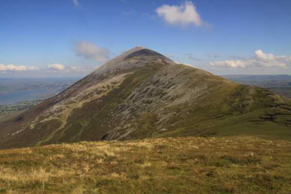
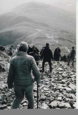
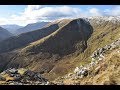
Croagh Patrick is, by far, the most climbed mountain in Ireland; we would estimate that upwards of 250,000 people per annum climb the mountain. There are three possible approaches to the summit, the first via the pilgrim path from Murrisk. This is a well signposted path. The second is from the Mountain Rescue base at Taobhnacroibhe off the Leenane rd (Turn right at the sign for Knappagh). The third option is the least used of all three, approaching from the Lecanvy side, eventually joining the old mining track left over from the shameful gold prospecting efforts of the 1980's.
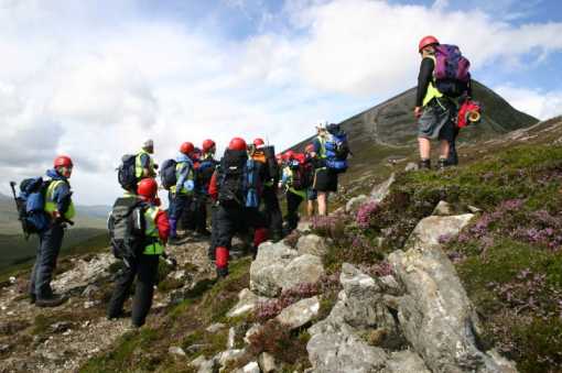
Being the most popular mountain in Ireland also means that "The Reek" is also the location for most activities carried out by Mayo Mountain Rescue team averaging 30+ rescues per annum. Considering that because of its popularity it attracts more inexperienced climbers than most other mountain in the country, the MMRT appeal to anyone considering climbing the mountain to follow a few basic guidelines:

1. Wear proper footwear, ideally something with good ankle support and sole grip.
2. Bring, as a minimum, a waterproof layer and some spare clothes
3. Bring something to drink (as a minimum a small bottle of water) and eat, ideally something like chocolate to provide energy.
4. Consider bringing a stick or walking pole, Sticks are available to rent or buy at Murrisk car park.
5. Leave notice with someone of your plan to climb and your expected time of return.
6. A mobile phone could be useful but a signal on the mountain is not guaranteed. A whistle or flashlight could prove even more useful in locating you if you get lost.
7. If you are feeling tired before reaching the saddle and you doubt your ability to reach the summit trust your instinct and don't be afraid to turn back
8. If you do get into difficulty and require assistance or encounter someone else requiring assistance dial 999/112 and ask for Mayo Mountain Rescue Team. Bear in mind however that expected time for arrival of the voluntary team, from time of raising the alarm, can be anything up to 3 hours depending on your location on the mountain, so that if a casualty is able to get themselves safely off the mountain in this time they would be advised to attempt to do so.

Croagh Patrick has a church and toilets located at the summit; the toilets are open all year round and provide basic shelter in severe conditions. The church is open daily from approx 10am to 3pm during July and August.
Some parts of the mountain are severely affected by erosion and all parts of the path are subject to considerable littering particularly from discarded bottles, sweet wrappers and clothing. MMRT would appeal to ALL climbers to adhere to the country side code, leave no trace, bring litter home and try to stick to the path to minimise further erosion on the mountain.

On behalf off all from MMRT we wish you a safe and enjoyable climb - For further info visit www.mayomrt.com Linkback: mountainviews.ie/summit/65/comment/3282/
Read Less
Read More

phutch on Croagh Patrick
by phutch 20 Aug 2004
Climbed the Reek on a good day in july 04. Errosion is very bad on the right hand side of the path going up the last 200m. sticking to the scree doesnt make this steep part much more difficult and coming down offers somtimes more predictable footing than the sandy eroded area. Great views clew bay, north towards Achill and Nephin beg range and south towards the partry mountains, sheefery hills, mweelrea and connemara. Clare island looks like a big whale gaurding the entrance to clew bay.
The little church at the top provides a good shield from the strong winds. it was locked though Linkback: mountainviews.ie/summit/65/comment/1098/
Read Less
Read More
EDIT Point of Interest
text
Videos


Recent Contributions
x
Conditions and Info
Use of MountainViews is governed by conditions and a privacy policy.
Read general information about the site.
Opinions in material here are not necessarily endorsed by MountainViews.
Hillwalking is a risk sport. Information in comments, walks, shared GPS tracks or about starting places may not be accurate for example as regards safety or access permission. You are responsible for your safety and your permission to walk.
See the credits and list definitions.

OSi logo
OSNI/LPS logo
Open Street Map
(Various variations used.)
British summit data courtesy:
Database of British & Irish Hills