Members and Supporters, the MountainViews Committee requests your help to meet the costs of the website and of other activities such as insured events or publications.
Feature count in area: 12, all in Louth,
OSI/LPS Maps: 29, 36, EW-CLY
Highest Place: Slieve Foye 587m
Starting Places (24) in area Cooley Mountains: Annaloughan Loop Walk CP, Beck's Lane, Cadger's Bridge, Carlingford Car Park, Carlingford Greenway, Clermont Junction, Clermont Pass Bridge, Corna Mucklagh House, Deserted Village, Feede South, Flagstaff Viewing Point, Foxes Rock SW, Glenmore Tain Way, Grange Cross, Long Woman's Grave, Lower Faughil Road, Slieve Foye Viewing Point, Slievefoy Forest CP, Slievenagloch N, Spellickanee Mid, St Oliver's Park, The Ben Rock, The Lumpers, Two Mile River CP
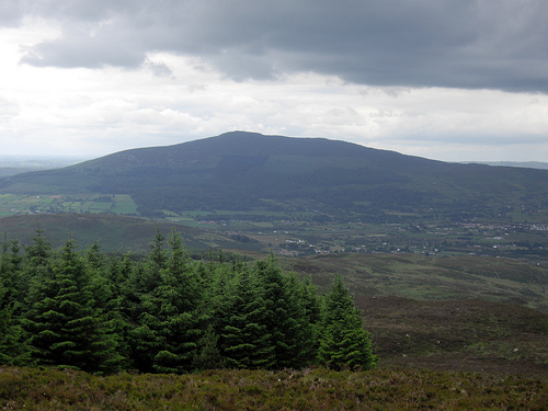
Summits & other features in area Cooley Mountains: N: Cooley North: Anglesey Mountain 421m, Carnavaddy 475m, Clermont 444m, Clermont Carn 510m, Clermont Carn NE Top 448m S: Cooley South: Barnavave 350m, Slieve Foye 587m, Slieve Foye North-West Top 548.1m, Slievenaglogh 310m, The Eagles Rock 530m, The Foxes Rock 404m, The Ravens Rock 457m
Note: this list of places may include island features such as summits, but not
islands as such.
Clermont, 444mHill
Place Rating ..
, Louth County in Leinster province, in no lists, Clermont is the 757th highest place in Ireland. Clermont is the most westerly summit and also the second most northerly in the Cooley Mountains area.
Grid Reference J09848 17129,
OS 1:50k mapsheet 36 Place visited by: 123members, recently by: TommyMc, Carolineswalsh, Jai-mckinney, Oscar-mckinney, MickM45, newpark-cc, jgfitz, archmeister, Dee68, Andy1287, atlantic73, Carolyn105, Kirsty, PPruzina, trostanite
I visited this place: NO (You need to be a logged-in member for this.)
Longitude: -6.321933, Latitude: 54.091622, Easting: 309848, Northing: 317129,
Prominence: 29m, Isolation: 0.7km ITM: 709774 817138 Bedrock type: Microgranite with granophyric texture, (Granophyre) Notes on name: This name, like Clermont Carn, records the association with Lord Clermont of Ravensdale, whose residence was Ravensdale Park in the early 19th century.
Short or GPS IDs, 6 char: Clrmnt, 10 char: Clermont Linkback: https://mountainviews.ie/summit/639/
Clermont was the second summit in my 5 peak hike beginning at Anglesey and ending at Carnavaddy (see Anglesey entry for start point info). From the summit of Anglesey, Clermont appears as a boggy mound off to your right (really south west), requiring a brief detour if your aim is Clermont Cairn with its prominent masts . Fortunately a fence can be followed down, around and up to the featureless summit of Clermont. If you look at the map, it does seem like this fence follows the line of the border here, where a small section of Co. Armagh containing Clontygora Wood juts conspicuously into Co. Louth. The terrain is quite tough going on the ascent and I walked alongside the old wall that eflanaga mentions, itself running parallel to the fence as I recall. The summit appears to be a little to the left (west) of the top of the wall, somewhere amidst the heavy undergrowth. The views here are very impressive: I found this to be one of the best vantage points to appreciate the Ring of Gullion. There is also a view down to The M1 Motorway with Dundalk beyond it; the imposing Crowne Plaza Hotel and Dundalk IT wind turbine could be made out. Linkback: mountainviews.ie/summit/639/comment/3923/
Read Less
Read More
pdtempan on Clermont
by pdtempan
3 Jun 2009
(Continued from Anglesey Mountain) I made a bee-line from Anglesey Mountain to Clermont. The heather got quite high and energy-sapping as I neared this last top. From the summit, I made straight for the corner of forestry and along the edge of the forest to the hairpin bend, and so back up the road to my bike. By now I was exhausted. Fortunately it was mostly downhill to Newry, but the few small stretches of uphill around Clontygora and Fathom were killers. At the first available shop on the outskirts of Newry, I refuelled on Lucozade and Snickers, and the sugar-rush restored my energy for the last couple of miles to the station. A great day out, 5 new peaks bagged plus Slieve Foye again, but what a brilliant invention heather-proof socks would be! Linkback: mountainviews.ie/summit/639/comment/3808/
Read Less
Read More
eflanaga on Clermont
by eflanaga
10 Nov 2007
Leaving Anglesey Mtn summit (see for first leg of walk) the route to Clermont is straightforward on a bearing of 232 degrees. Leg starts with a short drop, crossing a distinct track IA (J10190 17402), and subsequent rise across open moor bringing you on to the first top (444 metres) and a similar drop followed by another fairly short rise over relatively heavy gorse to take you to the main summit area, which appears to be at the highest point of a ruined wall, or a few metres beyond it at IB (J09891 17113) coming in at 448m. (forgot to take photos on summit!). A clear narrow track leaves the summit, dropping down gently past edge of forested area. I was making for Clermont Cairn so decided to go towards the service road and then up obvious rough and stony track towards the masts. Note of caution here, from the edge of the forested area, just below Clermont, there are five or six camouflaged ‘shiucs’ - drains - (some quite deep) ready to catch the unwary. Linkback: mountainviews.ie/summit/639/comment/2899/
Use of MountainViews is governed by conditions and a privacy policy.
Read general information about the site. Opinions in material here are not necessarily endorsed by MountainViews.
Hillwalking is a risk sport. Information in comments, walks, shared GPS tracks or about starting places may
not be accurate for example as regards safety or access permission. You are responsible for your safety and your permission to walk.
See the credits and list definitions.


 Our Facebook page.