Members and Supporters, the MountainViews Committee requests your help to meet the costs of the website and of other activities such as insured events or publications.
Feature count in area: 28, all in Kerry,
OSI/LPS Maps: 78, 79, EW-KNP, EW-R
Highest Place: Mangerton 838.2m
Starting Places (30) in area Mangerton: Cummeenboy Stream, Derrycunihy Church, Dunkerron Mid, Garries Bridge, Gowlane School Ruin, Hidden Valley Pet Farm, Inchimore West, Kenmare Bridge, Killarney Hiking Parking Lot, Knockanaskill N, Knocknsallagh Bridge, Loo River Junction, Looscaunagh Lough W, Lough Barfinnihy CP, Lough Guitane E, Lough Guitane SE, Lough Guitane W, Lynes Farm, Mangerton Walk N CP, Mangerton Walk Start, Molls Gap, Muckross Lake S, Old Rail Level Crossing, Poulacapple, River Roughty, Rossacroo na Loo Forest, Sahaleen Bridge, Shaking Rock W, Shronaboy Farm MTB, Torc Waterfall CP
Summits & other features in area Mangerton: Cen: Dromderlough: Dromderalough 650m, Dromderalough NE Top 654m, Dromderalough NW Top 625m, Knockbrack 610m, Knockrower 554m, Shaking Rock 402m Cen: Inchimore: Inchimore 256m Cen: Mangerton: Glencappul Top 700m, Mangerton 838.2m, Mangerton North Top 782m, Stoompa 705m, Stoompa East Top 608m NE: Crohane: Bennaunmore 454m, Carrigawaddra 425m, Crohane 650m, Crohane SW Top 477m NW: Torc: Cromaglan Mountain 371m, Torc Mountain 534.8m, Torc Mountain West Top 479.4m SE: Esknabrock: Esknabrock 406m SW: Peakeens: Derrygarriff 492m, Derrygarriff West Top 382m, Foardal 409.8m, Knockanaguish 509m, Peakeen Mountain 554.7m, Peakeen Mountain Far NW Top 525.5m, Peakeen Mountain North-West Top 522.7m, Peakeen Mountain West Top 538.7m
Note: this list of places may include island features such as summits, but not
islands as such.
Bennaunmore, 454mHill An Beannán Mór A name in Irish,
Place Rating ..
, Kerry County in Munster province, in Carn Lists, Bennaunmore is the 722nd highest place in Ireland.
Grid Reference W03505 81946,
OS 1:50k mapsheet 79 Place visited by: 75members, recently by: DeirdreM, Grumbler, SmirkyQuill, eamonoc, eoghancarton, JohnAshton, mh400nt, Fergalh, daitho9, jgdarcy, chelman7, peter1, learykid, Dbosonnet, Wilderness
I visited this place: NO (You need to be a logged-in member for this.)
Little to add by way of instructions to Conor74's excellent entry. This little mountain and the valleys to the south of Lough Guitane are known collectively as Cappagh (pron. KippOCK - a sure way of telling a native!), and the peak is just one of many items of interest in this vicinity. Bennaunmore itself is the stump of an ancient volcano. In addition to the six-sided rocks alluded to by Conor74, look out for the white easily pulverised stones, apparently the remains of volcanic ash. The valley was used in days of yore as a short cut from the Glenflesk and Sliabh Luachra area to Kilgarvan and Kenmare to the south. A rock by a barely discernable trackway, near A (W038 812) at the NW corner of Lough Crohane (if my memory is correct), holds the inscriptions of people who once travelled through this now-desolate valley. These include a 'DERMID O DONNOGHUE 1769'. The O'Donoghue's of the Glen were the local clan that managed to hold sway here despite the dispossessions following the Battle of the Boyne. The English administration was afraid to interfere with them, rough justice having being meted out to new settlers on this territory, and they were left in relative peace for a considerable period in the Penal Times. Geology, history and scenery in a most unusual setting. Linkback: mountainviews.ie/summit/606/comment/6578/
Read Less
Read More
Kerry
by Conor74
23 Nov 2010
Came at this from the Lough Guitane side. After the TOP petrol station in Glenflesk, take the next left (signposted Lough Guitane) and drive past the Glenflesk Art Gallery. Keep an eye out for a white wall on the left with a gate about 500 yards beyond this, looks like an entrance to a private house but takes you around the east side of the lake. The road is very bad, if driving watch the shocks. Go through another gate warning walkers not to bring dogs and marked 'Private Property No Shooting' and park in field there. Walk along track past an old farmhouse with a red tin roof, and Bennaunmore is obvious ahead of you, rising between Stoompa East Top and Crohane, which apparently form the sidewalls of the prehistoric volcano crater, with Bennaunmore being the lava plug.
Walked up the valley on the east side of Bennaunmore, which leads steeply up a wooded glen. Lovely walk, though some of it on scree and broken rock which has fallen from the east side of the mountain. When the valley levels off, the columns of rock referred to by Richard Mersey and just about every writer who has walked along here are evident. When I reached the southern point of Lough Nabroda, I scrambled due east up the side of the mountain. This was rather steep and tested the ankles. One can also head on to Crohane lake.
Descended an easier route to the south of the mountain and towards Crohane Lake, from where one can return to the car along through a wonderful petrified wood between Bennanunmore and Stoompa East (in fact not sure if it's really petrified, but the trees are very gnarled - looks eerie, but great, in the winter), or one can ascend to the east and head up Crohane. Great place for a winter walk. Linkback: mountainviews.ie/summit/606/comment/6163/
Read Less
Read More
sparow on Bennaunmore
by sparow
2 Nov 2007
Generally people come at this from the lough guitane side. We tried from the kilgarvan/kenmare road. You can park very easily in the forest across from the millenium forest and hike up through the forestry plantation (with all the scratches this entails). Once clear of the forest it's rotten heather covered boulders. Our intent was Crohane but the ankles wouldn't take it. So we did Beenaunmore instead - quite pleasant and easy. Fantastic views and feels very wild. Easy access, easy parking but route finding and terrain are very tough for the first few kilometers. Linkback: mountainviews.ie/summit/606/comment/2878/
Read Less
Read More
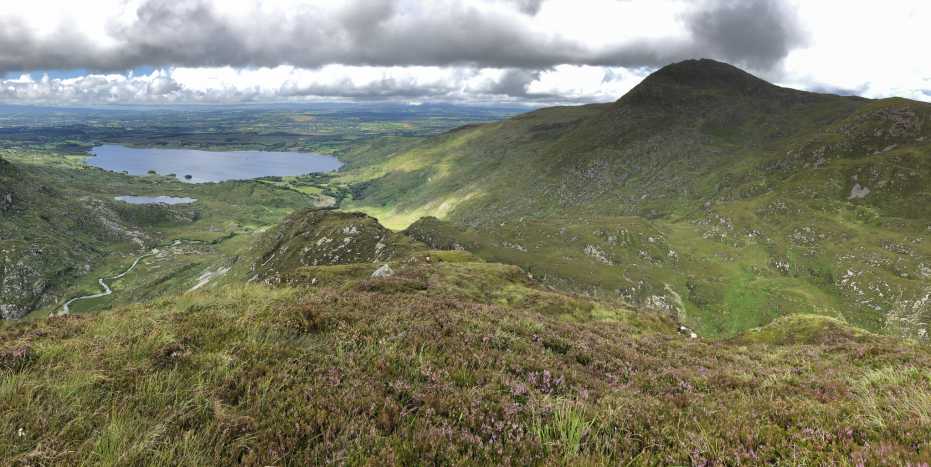
Picture: Lough Guitane with Crohane in shadow.
Great views in a less frequented place.
by peter1
29 Jul 2020
I approached the hill from Crohane over some very rough ground, mostly in cloud, rain and mist. Luckily for me, the sun came out and this is the view north from the summit. As others have written, the ground is tough going with tussocks of grass hiding rocks and potholes. In some places, in the descent from Bennaunmore, I was wading through waist high grass and ferns taller than me! I would recommend full leg cover as well as gaiters, as the ground is also very boggy. Still, a great day out! Linkback: mountainviews.ie/summit/606/comment/20827/
Read Less
Read More
Coming from Stoompa
by markmjcampion
6 May 2015
You can also come at this hill from the Stoompa direction. There's an easy descent down a wide gully on the south east of eskduff Mountain. After that it's an easy pull up onto B. Linkback: mountainviews.ie/summit/606/comment/17980/
Use of MountainViews is governed by conditions and a privacy policy.
Read general information about the site. Opinions in material here are not necessarily endorsed by MountainViews.
Hillwalking is a risk sport. Information in comments, walks, shared GPS tracks or about starting places may
not be accurate for example as regards safety or access permission. You are responsible for your safety and your permission to walk.
See the credits and list definitions.


 Our Facebook page.