Members and Supporters, the MountainViews Committee requests your help to meet the costs of the website and of other activities such as insured events or publications.
Feature count in area: 25, all in Kerry,
OSI/LPS Maps: 70, 71, 78, EW-DC, EW-DE, EW-DW
Highest Place: Beenoskee 826m
Starting Places (34) in area Central Dingle: Anascaul Village, Annascaul Lake, Ballyduff Grave Yard, Brandon Village, Cloghane Community Centre, Conor Pass, Doonore South, Doorah, Dromavally Mountain SE, Emlagh Cross, Emlagh Wood, Farrannakilla School, Glan Mountain, Glanteenassig Lane, Glanteenassig Wood CP, Glennahoo River, Hostel Cloghane Village, Killiney R560 Junction, Kilmore Lodge, Lios Pole Church, Lisduff Rath, Lough Camclaun, Lough Caum, Lough Doon CP, Lougher, Maum Cross, Maumnahaltora Cross, Minard Beach, Mullaghveal Farm, Owenascaul Estuary, Pedlars Lodge, Pilgrimage Trail Owenmore River, Sauce Creek Walkway Dingle Way, Teerbrin
Summits & other features in area Central Dingle: Cen: Annascaul Lake West: Cnoc na Bánóige 641.6m, Cnoc na Bánóige North Top 447.6m, Knockmulanane 593.2m, Knockmulanane West Top 563.5m Cen: Dromavally: Cummeen 477m, Dromavally Mountain 552m, Knocknakilton 423m N: Annascaul Lake North: Coombane 610m, Beenatoor 592m, Beenoskee 826m, Stradbally Mountain 798m N: Carrigdav: Carrigadav 240m N: Fermoyle: Farrandalouge 144m S: Annascaul: Beenmore 252m, Brickany 374m, Knockafeehane 301m, Knocknanacree 286m W: Ballyduff: Slievenalecka 458.4m, Beenbo 476.7m, Slievenagower 485.8m W: Slieveanea: An Cnapán Mór 649m, Knockmoylemore 493m, Croaghskearda 608m, Slievanea 628.7m, Slievanea NE Top 670.7m
Note: this list of places may include island features such as summits, but not
islands as such.
Slievenalecka, 458.4mHill An Starraicín A name in Irish,
Place Rating ..
(Ir. An Starraicín [OSI], 'the steeple'), Struicín, Steeple, Kerry County in Munster province, in Carn Lists, An Starraicín is the 704th highest place in Ireland.
Grid Reference Q52775 06407,
OS 1:50k mapsheet 70 Place visited by: 60members, recently by: Colin Murphy, maoris, chelman7, Oscar-mckinney, Jai-mckinney, Carolyn105, Moses, eiremoss34, annem, John.geary, mh400nt, Sleibhte21, abcd, denistreacy, JohnAshton
I visited this place: NO (You need to be a logged-in member for this.)
Longitude: -10.153601, Latitude: 52.190276, Easting: 52775, Northing: 106408,
Prominence: 71m, Isolation: 1.2km ITM: 452757 606462 Bedrock type: Cross-bedded sandstone, (Coumeenoole Sandstone Formation) Notes on name: This peak earns its name with its pointed peak.
Short or GPS IDs, 6 char: Slvnlc, 10 char: Slvnlck Linkback: https://mountainviews.ie/summit/599/
Gallery for Slievenalecka (An Starraicín) and surrounds
Summary
for Slievenalecka (An Starraicín):
Great viewpoint for lakes and wild plateau.
Summary created by simon3, jackill
2015-07-03 09:41:36
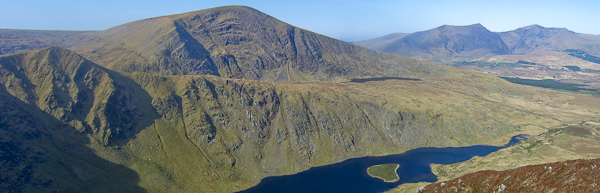
Picture: Looking at An Starraicín with Slievanea NE Top behind
Park at Ballyduff graveyard, BlDuff Grv (Q54076 10104) , room for 10 cars.
Walk back towards the R560 from the graveyard and turn right. Walk around 500m along the road and cross the bridge over the Glennahoo River. Take care while walking along the R560 as it is a busy road with no verges. After crossing the bridge, continue along the R560 for another 300m. Leave the R560 and turn right into a track at A (Q54600 10350). There is an old farmhouse with dormer windows and a sloped flat roof extension at the track entrance. Continue south-eastward for around 150m along this track to reach a T-junction.
Turn right there and follow a lane southwards to Maghanaboe at the head of the valley. The Glennahoo River twists and turns along the valley floor to the right. The narrow valley, some 3km long, is flanked by a sweep of steep slopes clothed with banks of scree. Go to Beenbo first and then cross from there east to Slievenagower and then Slievenalecka.
Note: We no longer recommend going on the ridge immediately south of the graveyard because of access issues.
There is a steep but much more direct route up this mountain. Park on the roadside at about KlMor Lg (Q522 089) where the road from Cloghane meets the road over the Connor Pass. There is a gate opposite and a public path that leads to Loch A'Duinn. Follow this path for about a mile and then head off to the right before you reach the lake. Ascend Slievenalecka directly up its north ridge. There is a line of fencing along the ridge. This is a testing climb but doesn't feel unsafe. Car to the summit shouldn't take much more than 1 hour. From the summit it is worth exploring the Coumanare Lakes. Linkback: mountainviews.ie/summit/599/comment/18305/
Read Less
Read More
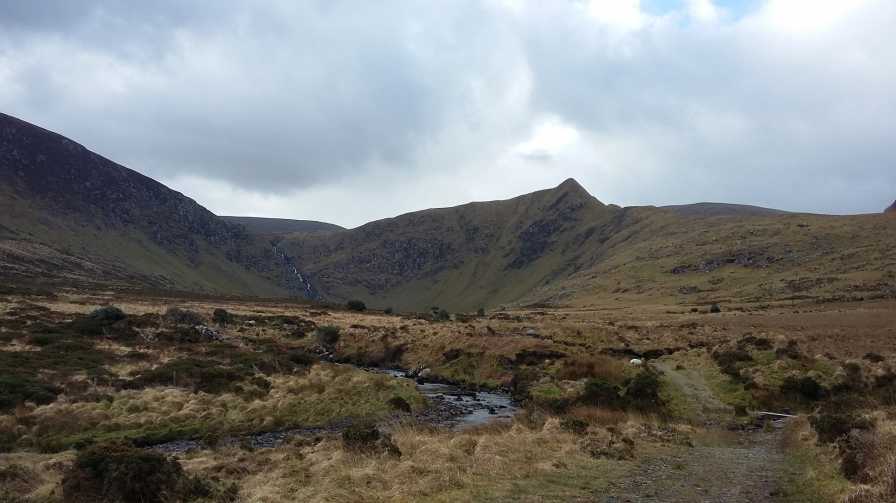
Picture: An Starraicín from Loch an Duin valley to the northeast
Arguably best appreciated from its northern side
by Bunsen7
18 Apr 2017
A distinctive peak noticeably spotted from the road towards the Conor Pass at the junction with Cloghane. By contrast, it looks very diminutive from the boggy plateau to the south.
You will see a track on the OS map that leads from the turn for Cloghane towards Loch an Duin.
Following the advice of aidand, I used this track initially before heading over trackless ground onto the northern ridge of Slievenalecka and upwards to the summit.
Word of warning, this hill drops precipitously from its north east, but to the north north west, the drop is less severe and you can ascend this way following the oddly placed fence.
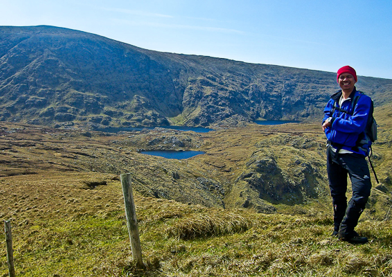
Picture: On the back of An Starraicín, looking at An Cnapán Mór
Who is this smiling man?
by jackill
11 Jun 2011
Way back in April 2010 I was sworn to secrecy by this man. Why you may ask. Well he doesn't know the third secret of Fatima and he didn't help America fake the moon landings. His name is Adrian Hendroff and he had invited me on a walk that was to feature in his book "The Dingle, Iveragh & Beara Peninsulas : A Walking Guide"( in the shops now by the way).It featured a quartet of sub 500 meter summits east of Dingle and to tell the truth I wasn't expecting much. Oh was I wrong. Magnificent, distinctive peaks seldom seen and seldom mentioned bypassed for their more famous neighbours. If you get here on a clear day you will be the happiest hillwalker in Ireland.
The cover of Adrians book has another photograph taken on this route, I'm not a bit sore that it features MV member dbloke more prominently than me! Linkback: mountainviews.ie/summit/599/comment/6372/
Read Less
Read More
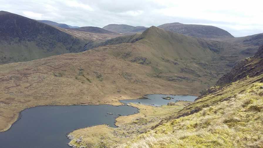
Picture: A view from the lower northern slopes of Slievenea NE
A view from the lower northern slopes of Slievenea NE
On Sun 03 Nov did a nice circular route of peaks around L.Iarthair and L. Mean E of Conor Pass including An Starraicin. There was spectacular view northwards and there looked like an interesting ascent up the spur Loch an Duinand and back down over Sli na gCorr Linkback: mountainviews.ie/summit/599/comment/3424/
Use of MountainViews is governed by conditions and a privacy policy.
Read general information about the site. Opinions in material here are not necessarily endorsed by MountainViews.
Hillwalking is a risk sport. Information in comments, walks, shared GPS tracks or about starting places may
not be accurate for example as regards safety or access permission. You are responsible for your safety and your permission to walk.
See the credits and list definitions.


 Our Facebook page.