This website uses cookies, which are small text files that the website puts on your device to facilitate operation. Cookies help us provide a better service to you. They are used to track general user traffic information and to help the website function properly.
West Cork MountainsArea, NW: Knocknamanagh
Subarea
Feature count in area: 62, by county: Cork: 45, Kerry: 24, of which 7 are in both Cork and Kerry,
OSI/LPS Maps: 78, 79, 85, 86, 88, 89
Highest Place: Knockboy 704.8m
Starting Places (47) in area West Cork Mountains: Barley Lake North, Barrboy, Caha Pass, Carranmore, Carrigacappeen, Carriganass Castle, Castle Donovan Car Park, Clearagh House, Coolkellure House, Coomhola Bridge, Corrigatirra, Cousane Gap, Cummer Lough East Road, Derreencollig Wood, Esk Boreen, Fuhiry Wood, Garinish Island Pier, Glasagarav River Bridge, Glasnacummeen Stream, Glengarriff, Glengarriff Nature Reserve CP, Gorteeniher Drimoleague Heritage Walk CP, Gortloughra River Road, Gougane Barra Oratory, Gougane Barra Park CP, Grousemount Wind Farm, Kealkill Village, Knockanuha, Knockbrack South, Lough Atooreen N, Lough Nambrackderg North, Lough Nambrackderg Wood, Lough Nambreacdearg, Mealagh Bridge, Molly Gallivan's Visitor Centre, Nowen Hill West Road, Owvane River Bridge, Pookeen North Top Road, Pooleen Wood Car Park, Priests Leap, Reenroe Bridge, River Roughty, Shandrum Concrete Silo, Sillahertane Stream, Slaheny River Horseshoe, Top of Coom, Turner's Rock Tunnel
Summits & other features in area West Cork Mountains: Cen: Maughanaclea: Maughanaclea Hills East Top 470m, Maughanaclea Hills West Top 452m Cen: Shehy More: Shehy More 545.6m, Shehy More SW Top 446m E: Clearagh: Clearagh Hill 287m E: Currane: Currane Hill 228m N Cen: Douce: Douce Mountain 476m, Doughill Mountain 471m N: Carran: Barnastooka 497m, Bealick 537m, Carran 604m, Carran Far NE Top 561m, Carran Far North Top 506m, Carran NE Top 555m, Carran South Top 567m, Knockantooreen 450m N: Conigar: Conigar 566m, Conigar SW Top 566m, Foilastookeen 540m N: Coomataggart: Carrigalougha 423m, Coomataggart 530m, Coomataggart SW Top 509m, Derrineanig 304m, Lackabaun 472m, Mweelin 487m NE Cen: Carrigarierk: Carrigarierk 343m NW: Barraboy: Barraboy Mountain 460m, Barraboy Mountain Far East Top 456m, Barraboy Mountain SE Top 409m, Derroograne 468m, Turners Rock 420m NW: Knockboy: Caoinkeen 692.8m, Caoinkeen South-East Top 553.5m, Coomhola Mountain 472m, Knockboy 704.8m, Knockboy North Top 651.2m, Knockboy South Top 533.3m, The Priest's Leap 519m NW: Knocknamanagh: Bird Hill 412m, Coomclogherane Top 449m, Gullaba Hill 603m, Knockbrack 440m, Knockbrack South Top 458m, Knocknamanagh 637m, Knocknamanagh NE Top 625m S Cen: Dunmanway Hills: Cashloura 296.8m, Coolsnaghtig 295.8m, Inchanadreen 310m S Cen: Nowen: Milane Hill 354.4m, Mullaghmesha 494.3m, Nowen Hill 535.2m, Nowen Hill Far West Top 405.2m, Nowen Hill SW Top 509m, Pookeen North Top 319m S: Leap Hills: Carrigfadda 311.7m, Killeigh Hill 229m, Knockarudane Hill 169m, Knockscagh 195m S: Skibbereen: Barryroe Hill 156m, Lick Hill 158m W Cen: Knockbreteen: Knockbreteen 239m W: Bantry: Knocknaveagh 282m
Note: this list of places may include island features such as summits, but not
islands as such.
Knockbrack South Top, 458mHill An Cnoc Breac (mullach theas) A name in Irish,
Place Rating ..
For origin of name, see Knockbrack., Kerry County in Munster province, in Carn Lists, Knockbrack South Top is the 708th highest place in Ireland.
Grid Reference V98283 68577,
OS 1:50k mapsheet 85 Place visited by: 19members, recently by: maoris, daitho9, Colin Murphy, madfrankie, Grumbler, jackos, John.geary, chelman7, hivisibility, markmjcampion, Fergalh, Wildrover, Wilderness, eamonoc, PeakPaul
I visited this place: NO (You need to be a logged-in member for this.)
Longitude: -9.477198, Latitude: 51.860675, Easting: 98283, Northing: 68577,
Prominence: 73m, Isolation: 0.9km ITM: 498255 568640 Bedrock type: Cross-bedded sandstone & siltstone, (Slaheny Sandstone Formation) Notes on name: Previously Coomclogherane in MV. Note that this peak is higher than Knockbrack itself.
Short or GPS IDs, 6 char: Knc458, 10 char: KnckbrSthT Linkback: https://mountainviews.ie/summit/591/
Gallery for Knockbrack South Top (An Cnoc Breac (mullach theas)) and surrounds
Summary
for Knockbrack South Top (An Cnoc Breac (mullach theas)):
The top between two tops
Summary created by Colin Murphy, thomas_g
2023-10-31 15:40:35
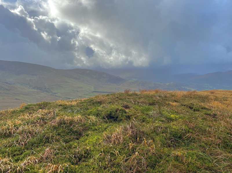
Picture: Summit area
A featureless top with lovely views, especially over the lake.
Best access is to park in the farmyard at A (V987 692) (Point A) with permission from the very friendly farmer. You have the choice of going to Knockbrack first and a boggy walk over to Knockbrack S Top or head south from the farm along the good track and climb the heather strewn hill to the top.
(Be warned, conversations with the granny who lives at the farm will result in a cup of tea whether you want it or not: old style Irish hospitality).
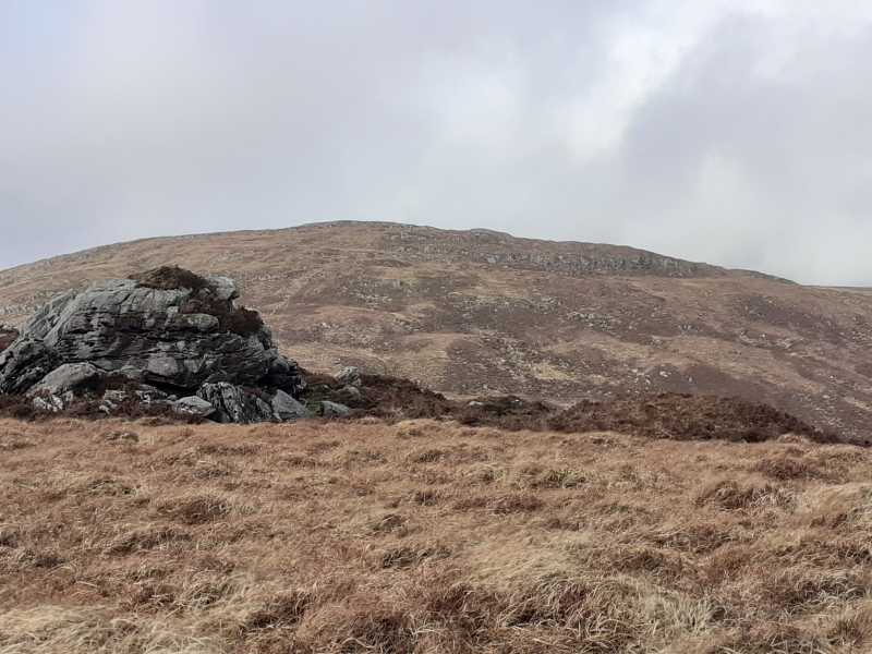
Picture: Knockbrack South Top from Coomclogherane Top
A relaxing part of the world
by markmjcampion
16 Feb 2021
Easy underfoot, great views and splendid isolation. I came at this hill from Knockbrack along a gently sloping ridge with no issues to report in terms of terrain. There's a couple of small satellite dishes on top but otherwise its fairly featureless aside from a small outcrop to the east of the summit which afforded some protection from the western winds as I made inroads into my food bank. Actually, there appears to be a farm vehicle track coming up the the col between the two Knockbracks which might provide for alternative access via the friendly farmer's farm. 15 mins from Knockbrack. Linkback: mountainviews.ie/summit/591/comment/22386/
Use of MountainViews is governed by conditions and a privacy policy.
Read general information about the site. Opinions in material here are not necessarily endorsed by MountainViews.
Hillwalking is a risk sport. Information in comments, walks, shared GPS tracks or about starting places may
not be accurate for example as regards safety or access permission. You are responsible for your safety and your permission to walk.
See the credits and list definitions.


 Our Facebook page.