Members and Supporters, the MountainViews Committee requests your help to meet the costs of the website and of other activities such as insured events or publications.
Antrim HillsArea, Cen: Central Antrim Hills
Subarea
Feature count in area: 27, all in Antrim,
OSI/LPS Maps: 14, 15, 4, 5, 8, 9
Highest Place: Trostan 550m
Starting Places (3) in area Antrim Hills: Donalds Carn, Rathlin Island Ferry Port, Whitehead Golf Club
Summits & other features in area Antrim Hills: Cen: Central Antrim Hills: Carncormick 436m, Collin Top 429m, Crockalough 402m, Mid Hill 440m, Skerry Hill 459m, Slieveanorra 508m, Slievenahanaghan 418m, Soarns Hill 403m, Tievebulliagh 402m, Trostan 550m Central Antrim Hills: Slievenanee 543m N: North Antrim Hills: Carnanmore 379m, Croaghan 417m, Crockaneel 403m, Cross Slieve 206m, Knocklayd 514m, Lannimore Hill 207m N: Rathlin Island: Kilpatrick (Rathlin Island) 134m S: Islandmagee: Donalds Carn 141m, Muldersleigh Hill 131m S: South Antrim Hills: Agnew's Hill 474m, Big Collin 353m, Black Hill 381m, Carnearny 319m, Douglas Top 402m, Slemish 437.9m W: West Antrim: Long Mountain 215m
Note: this list of places may include island features such as summits, but not
islands as such.
Skerry Hill, 459mHill Cnoc na Sceire A name in Irish,
Place Rating ..
, Antrim County in Ulster province, in Carn Lists, Skerry Hill is the 702nd highest place in Ireland.
Grid Reference D13651 20606,
OS 1:50k mapsheet 9 Place visited by: 42members, recently by: Paddym99, garybuz, Colin Murphy, chelman7, Andy1287, Kirsty, Vfslb1904, Kilcoobin, LorraineG60, Kilcubbin, MichaelG55, FatPete, eamonoc, pdtempan, Ulsterpooka
I visited this place: NO (You need to be a logged-in member for this.)
Short or GPS IDs, 6 char: SkryHl, 10 char: Skery Hil Linkback: https://mountainviews.ie/summit/587/
Gallery for Skerry Hill (Cnoc na Sceire) and surrounds
Summary
for Skerry Hill (Cnoc na Sceire):
Nondescript hill
Summary created by Colin Murphy
2022-09-23 14:34:16
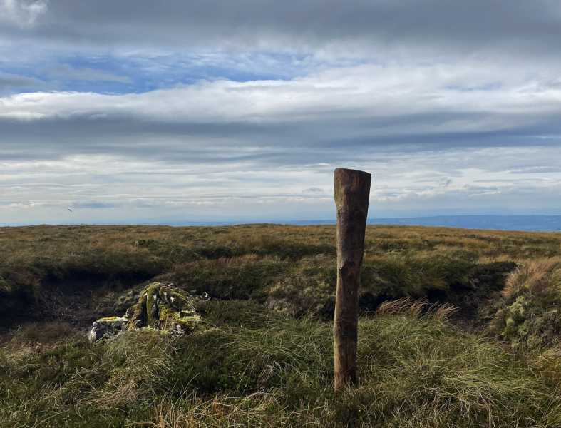
Picture: Summit stones.
Parking for 2 cars next to entrance to Gruig Windfarm at A (D13282 21721). There is a farm gate adjacent to the parking spot. Cross this and proceed SE through a gently sloping field of long grass & heather, making it a bit of a slog, then along the top of a high ditch for about 300m, which has a narrow trail that makes walking a little easier. The hill steepens a bit at B (D13537 21191). When ditch ends proceed directly SW for about 600m to the flattish summit. There is a moss-covered, stone marker of sorts next to a fence at the summit. A pole shoved into the turf next to it helps identify the spot. About 40 minutes to top.
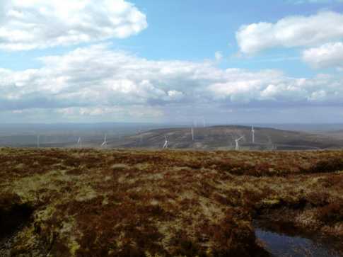
Picture: Looking west from Skerry Hill summit over Slievenahanaghan
slemish on Skerry Hill
by slemish
19 May 2009
Poor Skerry Hill - the forgotten hill of Antrim, forever upstaged by its 'bigger brothers' Trostan and Slievenanee. Not suprised it has been uncommented until now. However it is a splendid hill in its own right and reaches an impressive 459m - considerably higher than the more well-known Slemish or Carncormick. Skerry Hill is very accessible as two roads lead over its northern and eastern flanks. I parked at a little lay-by on the Old Cushendun Road about 2 miles north of Newtowncrommelin (C (D146 212)). It's less than 100 vertical metres from here to the summit. The climb is quite easy - not too steep but the usual terrain for this part of the world - very boggy and tussocky, peat hags etc. Soon you reach the summit which is marked by a small cairn. Majestic views on a day like this especially westwards over neighbouring Slievenahanaghan with its many wind turbines. The forested Slieveanorra stands proudly to the north with the twin domes of Slievenanee and Trostan dominating the view to the north-east. A very interesting view to the south-east with many Antrim hills visible - Carncormick, Slemish, Agnew's Hill, Carnearny and Divis to name but a few. To the south, Lough Neagh was glistening in the sunshine. The walk could be extended to Slievenahanaghan if desired. I however descended by the same route. Total trip - an easy 40 minutes. Linkback: mountainviews.ie/summit/587/comment/3767/
Read Less
Read More
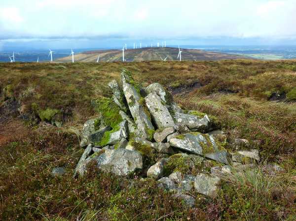
Picture: Summit Cairn on Skerry Hill with Slievenahanagan some 2.5k to the NW
Harry Goodman on Skerry Hill
by Harry Goodman
23 Sep 2009
I drove up the Old Cushendun road out of Newtown-Crommelin to where it takes a sharp left turn on to the Altnahinch Road where I parked at a small lay-by D (D14285 21327) on the left side of the road. From here I walked W along the road for 200m to a fence, marked on the Glens of Antrim 1:25,000 scale Activity Map, which initially runs E before turning SW . Once at the fence I kept it to my left and followed it right to the top of the hill which is marked by a small, moss covered, cairn of stones, GPS reading E (D13653 20604). The going was heavy and I had to make my way into or around a number of wet peaty bog holes on the way up.On arrival at the top I had no visibility due to dense mist when suddenly to my great delight it cleared to give me a full panorama of the views already well described in the comments of Slemish. Clearly the way up can simply be reversed by anyone simply wanting to go up and down this hill by the shortest route. However as I also wanted to include Slievenahanaghan in my round I headed NW down the hillside in the direction of a drainage ditch marked on the map and clearly visable on the ground. Progress was slow as I battled through dense clumps of knee high gorse and tussocky grass. The surprise I found at the bottom was a new access road not marked on the map which considerably eased my walk of some 800 metyres out to the road, after I climbed Slievenahanagan. Linkback: mountainviews.ie/summit/587/comment/4129/
Use of MountainViews is governed by conditions and a privacy policy.
Read general information about the site. Opinions in material here are not necessarily endorsed by MountainViews.
Hillwalking is a risk sport. Information in comments, walks, shared GPS tracks or about starting places may
not be accurate for example as regards safety or access permission. You are responsible for your safety and your permission to walk.
See the credits and list definitions.


 Our Facebook page.