Donation Request 2024

DONATE
Members and Supporters, the MountainViews Committee requests your help to meet the costs of the website and of other activities such as insured events or publications.
You do not have to be logged in to donate.
Features
Nearby features appear when you click the map.
Declutter tracks on map.
Place Search
Video
X
Pub: by
Mourne Mountains Area , E: Donard Subarea
Feature count in area: 58, all in Down, OSI/LPS Maps: 20, 29, EW-CLY
Highest Place: Slieve Donard 849m

Starting Places (33) in area Mourne Mountains:
Alex Steddom Tree, Aughrim Airstrip, Ben Crom Dam, Bloody Bridge Car Park, Carlingford Greenway, Carrick Little, Crocknafeola Wood, Crotlieve Mountain, Donard Car Park Newcastle, Drummanmore Picnic, Fofanny Reservoir, Forest Office CP, Gamekeepers Lodge CP, Happy Valley Trassey Rd, Hen Mountain CP, Leitrim Lodge CP, Mayo Road Corner, Meelmore Lodge, Newcastle Harbour, Ott CP, Red Bog Road, Rourkes Park, Sandy Brae, Silent Valley Reservoir Head Rd, Slieve Donard Trail Head, Slieve Foye Viewing Point, Slievefoy Forest CP, Spelga Dam E, Spelga Dam N, Spelga Dam S, Trassey Car Park, Two Mile River CP, Yellow Water Park

Summits & other features in area Mourne Mountains:
Cen: Loughshannagh: Ben Crom 526m, Carn Mountain 585.2m, Carn Mountain North Top 553.7m, Doan 592.6m, Ott Mountain 526.8m, Slieve Loughshannagh 617m, Slieve Muck 670.4m, Slievenaglogh 445m
E: Binnian: Slieve Binnian 745.9m, Slieve Binnian East Top 639m, Slieve Binnian North Top 678m, Slieve Binnian North Tor 682.5m, Wee Binnian 460m
E: Donard: Chimney Rock Mountain 656m, Crossone 540m, Millstone Mountain 460m, Rocky Mountain 524m, Slieve Donard 849m
E: Lamagan: Cove Mountain 654.8m, Slieve Beg 595.9m, Slievelamagan 702.2m
N: Bearnagh: Slieve Bearnagh 739m, Slieve Bearnagh North Tor 680m, Slieve Meelbeg 701.9m, Slieve Meelmore 687m
N: Castlewellan: Slievenalargy 280m, Slievenaslat 272m
N: Commedagh: Slieve Commedagh 767m, Slieve Corragh 641.9m, Slievenaglogh 584.4m, Slievenaglogh East Top 571m
N: Croob: Cratlieve 429m, Slieve Croob 534m, Slievegarran 391m, Slievenisky 446m
N: Rathfriland: Knockiveagh 235m
S: Kilkeel: Knockchree 306m
S: Rostrevor: Crenville 460m, Finlieve 578m, Slievemartin 485m, Slievemeel 420m, Slievemeen 472m
W: Hilltown: Gruggandoo 382m, Slieveacarnane 296m
W: Slievemoughanmore: Crotlieve Mountain 347m, Eagle Mountain 638m, Rocky Mountain 404m, Shanlieve 626m, Slievemoughanmore 560m, Tievedockaragh 473m, Wee Slievemoughan 428m
W: Spelga: Butter Mountain 500m, Cock Mountain 504m, Cock Mountain South-West Top 505m, Hen Mountain 354m, Pigeon Rock Mountain 534m, Pigeon Rock Mountain South Top 530m, Slievenamiskan 444m

Note: this list of places may include island features such as summits, but not islands as such.
Rating graphic.
Millstone Mountain, 460m Hill
Place Rating ..
, Down County in Ulster province, in no lists, Millstone Mountain is the 695th highest place in Ireland. Millstone Mountain is the most easterly summit in the Mourne Mountains area.
Grid Reference J37291 28507, OS 1:50k mapsheet 29
Place visited by: 103 members, recently by: Florence, John.geary, Teresa-ms, Matrim, daftgrandad, cmcv10, hak493r, Lauranna, Andy1287, pcman, Oscar-mckinney, dregish, Jai-mckinney, Carolyn105, abcd
I visited this place: NO (You need to be a logged-in member for this.)
Longitude: -5.897645, Latitude: 54.187175, Easting: 337291, Northing: 328507, Prominence: 25m,  Isolation: 1.2km
ITM: 737209 828512
Bedrock type: Granite granophyre, (Mourne Mountains granite)

  Short or GPS IDs, 6 char: MlstMn, 10 char: MlstnMntn

Linkback: https://mountainviews.ie/summit/584/
Gallery for Millstone Mountain and surrounds
No summary yet for this place .
Member Comments for Millstone Mountain
Comment create / edit display placeholder

            MountainViews.ie picture about Millstone Mountain
Picture: millstone mtn
gerrym on Millstone Mountain
by gerrym 28 Dec 2009
Start out from the supermarket sized carpark at Donard Park and follow the tried and tested route up along the Glen river. The path follows one bank of the river then the other, as bridges span deep incisions in the tough Mourne rock. At the third bridge (A (J365 297)) leave the crowds who continue with the river and take the forest track heading SE.

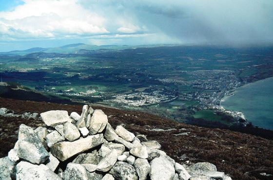
The track drops slightly before rising up out of the pine and holly trees to reach the working granite quarry below Thomas's Mtn. A fridge/freezer sized block was hewn and strapped ready for moving - unlike the small stream usually tumbling down the back of the quarry wall which was all but frozen due to the recent cold spell.This is a magnificent viewpoint down over Newcastle and the sweeping sands of Dundrum Bay. An amazing place to work i would think. Some motorbikes pulled into the quarry just after i had left obviously using the network of fairly good forest tracks.

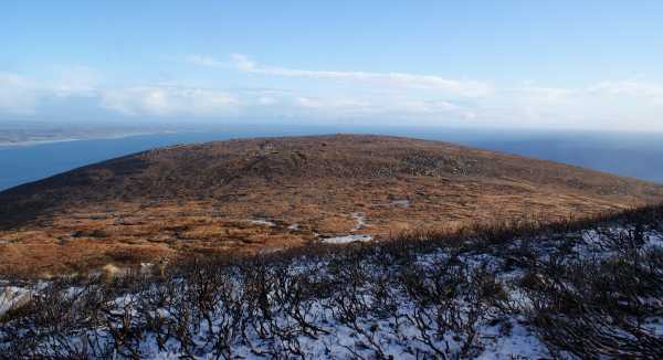
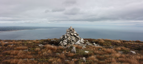
Continue past the quarry to a gate/stile and take a rough track immediately on the right, climbing above the quarry to the small stream. This was frozen into large chunks of ice as followed on the left side of the little valley it has carved out for itself. All other water on the hillside was similarly frozen and care was needed to avoid slipping. Recent fire has removed all but the bare arms of the heather on a large part of the hillside, aiding walking if nothing else. The cairn on top was reached in an hour.

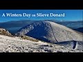
The views are extensive to the N and E - across the little harbour far below, Dundrum Bay, Stranford Lough, Belfast Hills, Irish sea til Isle of Man and a snow capped Slieve Croob. There was surprisingly no snow here (with the Sperrins having a covering from top to bottom) though a quick glance to the higher slopes of Donard fixed that. A very strong wind discouraged dawdling and everthing else!

This is really a stop on the way to Donard, though would make a great spot to spend some time on a lazy summers day. I headed for the full ferocity of winter atop Donard, descending gingerly to the saddle. Not wanting to tread warily on any more icy steps I headed over Slieve Commedagh and down her N ridge to meet the Glen River path on more level terms. A dander of nearly 6 mile in under 4 hours. Linkback: mountainviews.ie/summit/584/comment/4314/
Read Less
Read More

            MountainViews.ie picture about Millstone Mountain
Picture: The view to the north.
Fine views from Donard's smaller neighbour
by csd 17 Oct 2010
Millstone Mountain is inevitably dominated by its larger neighbour to the west, but is a fine summit in its own right with extensive views to the north as shown by this panorama. Linkback: mountainviews.ie/summit/584/comment/6138/
Read Less
Read More

            MountainViews.ie picture about Millstone Mountain
Picture: Shower approaching Millstone Mt
Harry Goodman on Millstone Mountain
by Harry Goodman 19 Dec 2009
A rewarding way to climb Millstone Mountain is to start at the car park at Newcastle Harbour B (J381 296) and follow the way marked route of The Granite Trail directly up through the forest. The steep trail up follows the line of a former funicular railway known locally as the Boggie Line which was used to transport the granite down from the mountain to the Harbour. The Granite Trail climb up is just over 1100 metres long to the Quarry below Millstone. After crossing the stile the track turns right past Millstone Mountain Quarry and follows along across another stile to a marker and viewpont ( highest point on the Granite Trail ) near Thomas Mountain Quarry. From C (J371 293) climb up around the right side of the quarry making sure to stay well away from the edge to your left side. Gradually work your way around from heading SW to go SE across a sream and up to the summit at 460m. ( If time and energy allows it is a rewarding approach to the top of Slieve Donard from Millstone Mt. Walk SW across a boggy dip before climbing up the Eastern slopes of Donard, initially over soggy and peaty terrain but increasingly rockey ground up to the Lesser Cairn at D (J35950 27900). From here a short walk SSW will take you to the highest point in Ulster. Descend W with a touch of N along the Mourne Wall to the coll at E (J24950 27950), then NE down the Glen River track to pick up the route down from Millstone at JA (J365 297) ) To descend directly from Millstone re-trace the route down NNW over the stream and then NE around the Quarry keeping it well to your right. Once down take the track heading NNW into the forest and follow it along to cross a bridge over the Glen River. ( If the walk up Donard has been taken this is the point where the two routes meet up for the final part of the descent down along the Glen River ) Turn right along a path which follows the line of the river down. At the next bridge turn right and once across, immeadiately left down the river track. On reaching Donard Bridge G (J372 302) do not go across but turn right and follow the forest track out to the public road and then left to the main Newcastle to Kilkeel road. Turn right and walk along to the Harbour Car Park. Linkback: mountainviews.ie/summit/584/comment/4155/
Read Less
Read More
EDIT Point of Interest
text
Videos


Recent Contributions
x
Conditions and Info
Use of MountainViews is governed by conditions and a privacy policy.
Read general information about the site.
Opinions in material here are not necessarily endorsed by MountainViews.
Hillwalking is a risk sport. Information in comments, walks, shared GPS tracks or about starting places may not be accurate for example as regards safety or access permission. You are responsible for your safety and your permission to walk.
See the credits and list definitions.

OSi logo
OSNI/LPS logo
Open Street Map
(Various variations used.)
British summit data courtesy:
Database of British & Irish Hills