Members and Supporters, the MountainViews Committee requests your help to meet the costs of the website and of other activities such as insured events or publications.
Feature count in area: 65, all in Kerry,
OSI/LPS Maps: 78, 83, 84, 85, EW-KNP, EW-R
Highest Place: Stumpa Dúloigh 784m
Starting Places (66) in area Dunkerron Mountains: Ballaghasheen Coilte, Ballaghasheen Pass Viewpoint, Ballaghbeama Gap, Bohacullia, Bridia Valley End, Cahersavane Road, Cahersavane Schoolhouse, Cloon Lough NE, Cloon Lough SE, Coad Cemetery, Coad Road End, Com an Chiste, Coomaclarig Bridge, Coomnahorna River, Coomyanna Bridge, Dereenavurrig, Derreendarragh Church, Derrynane Quay, Dunkerron Mid, Eagles Lough Access Trailhead, Esknaloughoge Forest Trailhead, Fermoyle Farm, Foot Stick Ford Road, Gap of Dunloe Head of, Glashaknockbrassel Stream, Glasheenoultagh Stream, Gortaclohane Lane End, Gortaclohane Lane NE Branch, Gortagowan Wood, Gowlane School Ruin, Gowlanes Wood, Graces Landing, Inchimore West, Isknagahinney Lough E, Kenmare Bridge, Knockanamadane, Knockanaskill N, Knocknasullig, Knocknsallagh Bridge, Laghtacallow, Lissatinnig Bridge Boreen, Looscaunagh Lough W, Lough Barfinnihy CP, Lough Brin S, Lough Coomeen SE, Lough Dromtine NE, Lough Dromtine SE, Lough Fada N, Lough Iskanamacteery N, Lough Iskanamacteery NW, Lough Reagh N, Maghanlawaun Bridia Valley, Molls Gap, Ochtiabh Road, Poulacapple, River Owroe Source, River Sneem Fermoyle Loop, Rossacoosane Mid, Sahaleen Bridge, Scarriff Island, Shamrock Farmhouse B&B, Sneem, Tooreenboy Lough, Tooreennafersha Mid, Tooreennafersha South, Waterville Promenade
Summits & other features in area Dunkerron Mountains: Knocknagantee Near West Top 628m Cen: An Bheann Mhór: An Bheann Mhór 674.7m, An Bhinn Láir 514m, Coomcallee 648.9m, Beann na Stiocairí 673.1m, Coomnahorna 590m, Glanbeg 485.8m, Slievenashaska 578m, Slievenashaska South Top 565.4m Cen: Knocknagantee: Knockmoyle 682.1m, Finnararagh 667m, Cnoc Breasail 591m, Knocknagantee 674.3m, Knocknagantee West Top 553m, Coomnacronia 636m, Coomura Mountain 666m Cen: Mullaghanattin: An Cnoc Riabhach 534m, Beann 752m, Beann Far SW Top 636.2m, Beann NE Top 692m, Beann South Top 639m, Beann SW Top 657m, Sallagh 570m, Mullaghanattin 773m, Mullaghanattin East Top 594m, Sallagh South-West Top 543m E: Kenmare: Gortamullin 205m, Knockanaskill 356m, Letter South 362m N: Knocknacusha: Knocknacusha 547m NE: Knocknabreeda Ridge: Crossderry 489m, Knocknabreeda 569m, Mothaillín 506m NE: Knocknagapple: Bascadh 595m, Bascadh West Top 569m, Boughil 631m, Cnoc na gCapall 639m, Knocklomena 641m NE: Stumpa Dúloigh: Broaghnabinnia 745m, Knockaunanattin 569m, Knockaunanattin West Top 466.1m, Stumpa Dúloigh 784m, Stumpa Dúloigh SE Top 780m, Stumpa Dúloigh SW Top 663m SW: Caherdaniel: Farraniaragh Mountain 468m, Eagle Hill 155m, Reenearagh 162m, Beenarourke 304m, Knocknasullig 117m, Cahernageeha Mountain 498.7m SW: Coad ( Castle Cove ): Beenrour 418m, Eagles Hill 549m, Mullaghbeg 509m SW: Coomduff: Coomduff 244m SW: Deenish: Deenish Island (2) 144m SW: Esknaloughoge: Esknaloughoge 416m, Esknaloughoge North Top 420m SW: Scarriff: Scarriff Island 252m SW: Sneem: An Bheann Mhór 309.3m, Dereenavurrig Hill 261m, Knockanamadane 270m, Knocknafreaghane 316.5m, Knocknagullion 413m SW: Staigue: Staigue Top 459m, Staigue NE Top 435m
Note: this list of places may include island features such as summits, but not
islands as such.
Stumpa Dúloigh SE Top, 780mMountain Stumpa Dúloigh (mullach thoir theas) A name in Irish,
Place Rating ..
For origin of name, see Stumpa Dúloigh., Kerry County in Munster province, in Arderin Beg, Vandeleur-Lynam, Irish Best Hundred Lists, Stumpa Dúloigh SE Top is the second highest mountain in the Dunkerron Mountains area and the 58th highest in Ireland.
Grid Reference V79037 79154,
OS 1:50k mapsheet 78 Place visited by: 144members, recently by: kelleher, rhw, maoris, Carolineswalsh, ToughSoles, Ansarlodge, Kaszmirek78, Krzysztof_K, Beti13, overthehill67, bagoff, Hjonna, chelman7, Taisce, SmirkyQuill
I visited this place: NO (You need to be a logged-in member for this.)
Short or GPS IDs, 6 char: Stm780, 10 char: StmpDúlghS Linkback: https://mountainviews.ie/summit/57/
Gallery for Stumpa Dúloigh SE Top (Stumpa Dúloigh (mullach thoir theas)) and surrounds
Summary
for Stumpa Dúloigh SE Top (Stumpa Dúloigh (mullach thoir theas)):
Ridge southeast of the Main Top
Summary created by Peter Walker, Onzy
2022-06-23 09:49:55
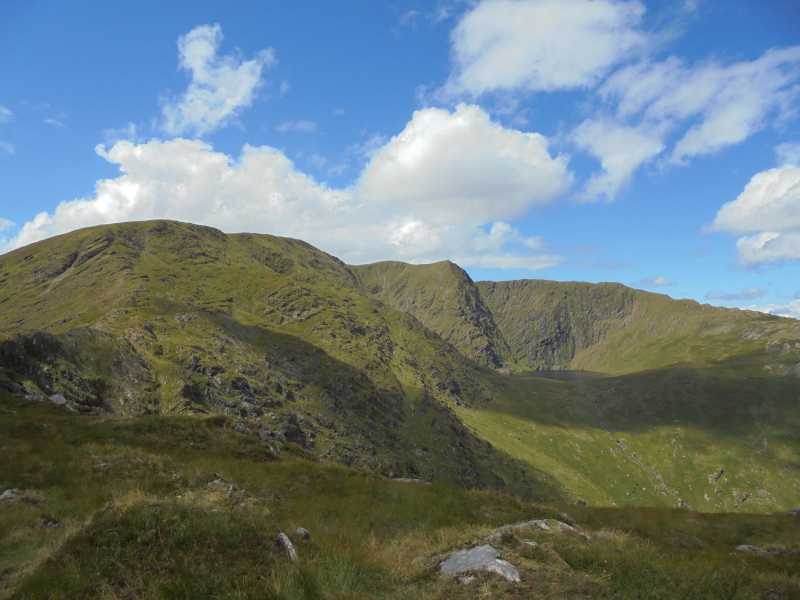
Picture: the southeast top from the east
Part of the Stumpa Duloigh massif, the southeast top of Stumpa Duloigh is an easy ridge which heads east from the main summit towards Knocknabreda.
This entire range of hills sits between the Reeks to the North and the Knocklomena to Boughil range to the south with the extended Dunkerron ridge lying to the south west and Molls Gap to the south east.
The hill can be reached from the Ballaghbeama Gap, over Knockaunattin and the main top, from parking around BallBeam (V755 781). It can also be reached directly from the Gearhameen Valley ascending to the ridge between it and Knocknabreda from the waterfall above Lough Reagh, parking in the valley around L Reagh N (V822 813).
However it is at its best as part of a circuit of Lough Duff beginning around L Reagh N (V822 813) where there are a number of spaces. From here you ascend alongside the waterfall behind Lough Reagh, up towards the col with Broaghnabinnia and along the ridge to Stumpa Duloigh and its SE top. From there you continue along a grassy boggy ridge to Knocknabreda, from where you must pick a descent to the valley over rock-studded grassy ground and around the occasional steep crag.
PLEASE NOTE: at the time of writing (Sept 2020) access has been withdrawn for the Lough Duff circuit described above. This continues to be the case in June 2022.
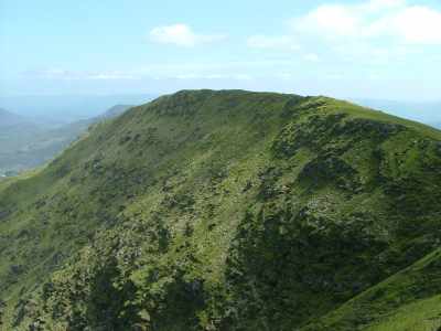
Stumpa Duloigh SE stretches out towards Knocknabreeda and is part of the large east facing corrie that cradles Lough Duff. It is the highest point on the ridge just left of centre. The sharp peak with the cliff falling into the lake is a minor top of Stumpa Duloigh, around 200m NE of the main top.
This is really just a ridge running SE from the summit. It drops steeply to Doo Lough (Lough Duff) to the north Linkback: mountainviews.ie/summit/57/comment/1829/
Read Less
Read More
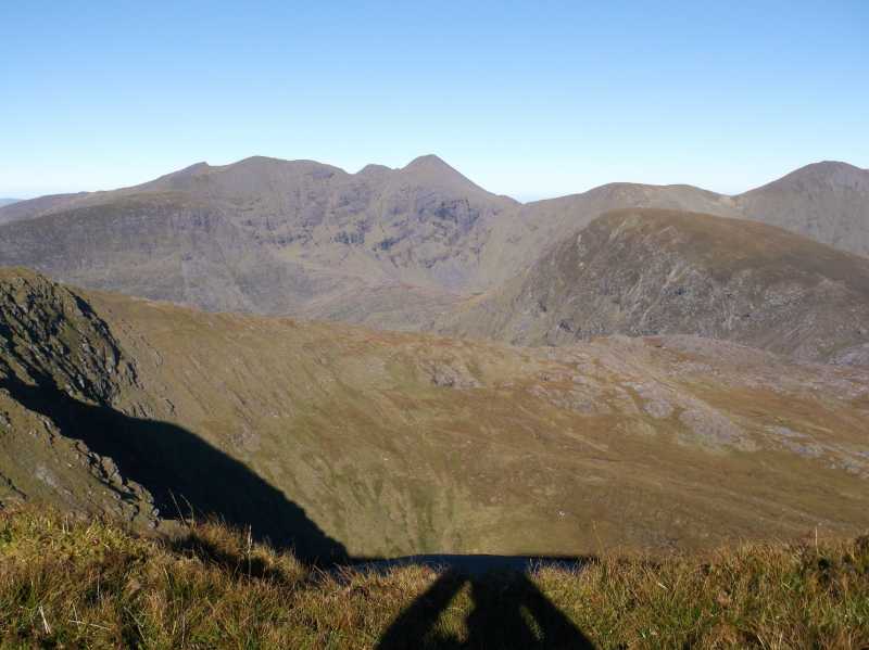
Picture: The long ridge to Stumpa Duloigh with Bruach na Binne on the RHS with Corrán Tuathail and Caher
Excellent Vantage Point for the Reeks
by ciarraioch
4 Nov 2012
This is a simple continuation from Stúmpa Duloigh and presents easy and pleasurable ridge walking after the previous exertions. Incomparable aspects of the Reeks and the mountains of Iveragh. Continue to Knocknabreeda taking extreme care to find the appropriate point of descent if returning to the Black Valley. Linkback: mountainviews.ie/summit/57/comment/14859/
Read Less
Read More
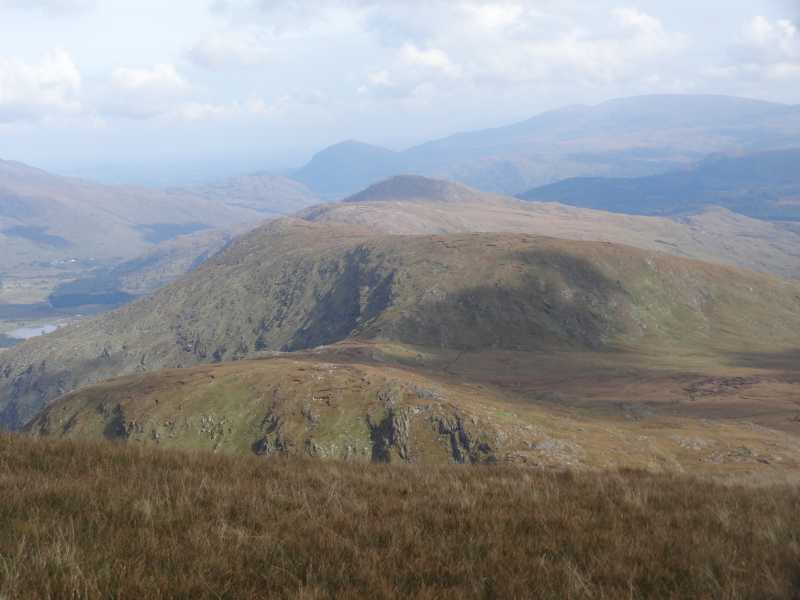
Picture: View East from the approach to the summit.
Fine views to the East...
by hivisibility
21 Oct 2016
The view to Knocknabreeda, Crossderry and Mothillín as seen from the aooroach to Stúmpa Dúloigh SE Top. Torc in the centre with Mangerton rising over to the right. Linkback: mountainviews.ie/summit/57/comment/18677/
Read Less
Read More
Access issues at V82178 81301 Gearhameen circuit high up the Black Valley - Stum
by nupat
10 Sep 2020
Today 09 Sep 2020 we aimed to start a circuit of the Gearhameen Valley starting at the above reference (included in Adrian Hendroff's Collins book 2011) but meet the couple who own the land at the start. We said "Good Morning, nice day .. we are going walking" to a couple on the roadside near the start. "Not anywhere on the left..on our land.its been terrible this year" We turned around and went elsewhere
Use of MountainViews is governed by conditions and a privacy policy.
Read general information about the site. Opinions in material here are not necessarily endorsed by MountainViews.
Hillwalking is a risk sport. Information in comments, walks, shared GPS tracks or about starting places may
not be accurate for example as regards safety or access permission. You are responsible for your safety and your permission to walk.
See the credits and list definitions.


 Our Facebook page.