Members and Supporters, the MountainViews Committee requests your help to meet the costs of the website and of other activities such as insured events or publications.
Feature count in area: 65, all in Kerry,
OSI/LPS Maps: 78, 83, 84, 85, EW-KNP, EW-R
Highest Place: Stumpa Dúloigh 784m
Starting Places (66) in area Dunkerron Mountains: Ballaghasheen Coilte, Ballaghasheen Pass Viewpoint, Ballaghbeama Gap, Bohacullia, Bridia Valley End, Cahersavane Road, Cahersavane Schoolhouse, Cloon Lough NE, Cloon Lough SE, Coad Cemetery, Coad Road End, Com an Chiste, Coomaclarig Bridge, Coomnahorna River, Coomyanna Bridge, Dereenavurrig, Derreendarragh Church, Derrynane Quay, Dunkerron Mid, Eagles Lough Access Trailhead, Esknaloughoge Forest Trailhead, Fermoyle Farm, Foot Stick Ford Road, Gap of Dunloe Head of, Glashaknockbrassel Stream, Glasheenoultagh Stream, Gortaclohane Lane End, Gortaclohane Lane NE Branch, Gortagowan Wood, Gowlane School Ruin, Gowlanes Wood, Graces Landing, Inchimore West, Isknagahinney Lough E, Kenmare Bridge, Knockanamadane, Knockanaskill N, Knocknasullig, Knocknsallagh Bridge, Laghtacallow, Lissatinnig Bridge Boreen, Looscaunagh Lough W, Lough Barfinnihy CP, Lough Brin S, Lough Coomeen SE, Lough Dromtine NE, Lough Dromtine SE, Lough Fada N, Lough Iskanamacteery N, Lough Iskanamacteery NW, Lough Reagh N, Maghanlawaun Bridia Valley, Molls Gap, Ochtiabh Road, Poulacapple, River Owroe Source, River Sneem Fermoyle Loop, Rossacoosane Mid, Sahaleen Bridge, Scarriff Island, Shamrock Farmhouse B&B, Sneem, Tooreenboy Lough, Tooreennafersha Mid, Tooreennafersha South, Waterville Promenade
Summits & other features in area Dunkerron Mountains: Knocknagantee Near West Top 628m Cen: An Bheann Mhór: An Bheann Mhór 674.7m, An Bhinn Láir 514m, Coomcallee 648.9m, Beann na Stiocairí 673.1m, Coomnahorna 590m, Glanbeg 485.8m, Slievenashaska 578m, Slievenashaska South Top 565.4m Cen: Knocknagantee: Knockmoyle 682.1m, Finnararagh 667m, Cnoc Breasail 591m, Knocknagantee 674.3m, Knocknagantee West Top 553m, Coomnacronia 636m, Coomura Mountain 666m Cen: Mullaghanattin: An Cnoc Riabhach 534m, Beann 752m, Beann Far SW Top 636.2m, Beann NE Top 692m, Beann South Top 639m, Beann SW Top 657m, Sallagh 570m, Mullaghanattin 773m, Mullaghanattin East Top 594m, Sallagh South-West Top 543m E: Kenmare: Gortamullin 205m, Knockanaskill 356m, Letter South 362m N: Knocknacusha: Knocknacusha 547m NE: Knocknabreeda Ridge: Crossderry 489m, Knocknabreeda 569m, Mothaillín 506m NE: Knocknagapple: Bascadh 595m, Bascadh West Top 569m, Boughil 631m, Cnoc na gCapall 639m, Knocklomena 641m NE: Stumpa Dúloigh: Broaghnabinnia 745m, Knockaunanattin 569m, Knockaunanattin West Top 466.1m, Stumpa Dúloigh 784m, Stumpa Dúloigh SE Top 780m, Stumpa Dúloigh SW Top 663m SW: Caherdaniel: Farraniaragh Mountain 468m, Eagle Hill 155m, Reenearagh 162m, Beenarourke 304m, Knocknasullig 117m, Cahernageeha Mountain 498.7m SW: Coad ( Castle Cove ): Beenrour 418m, Eagles Hill 549m, Mullaghbeg 509m SW: Coomduff: Coomduff 244m SW: Deenish: Deenish Island (2) 144m SW: Esknaloughoge: Esknaloughoge 416m, Esknaloughoge North Top 420m SW: Scarriff: Scarriff Island 252m SW: Sneem: An Bheann Mhór 309.3m, Dereenavurrig Hill 261m, Knockanamadane 270m, Knocknafreaghane 316.5m, Knocknagullion 413m SW: Staigue: Staigue Top 459m, Staigue NE Top 435m
Note: this list of places may include island features such as summits, but not
islands as such.
Stumpa Dúloigh, 784mMountain
Place Rating ..
(Ir. Stumpa Dúloigh [OSI 1:25,000], 'stump of the black lake')Maol an extra name in Irish, Kerry County in Munster province, in Arderin, Vandeleur-Lynam, Irish Best Hundred, Irish Highest Hundred Lists, Stumpa Dúloigh is the highest mountain in the Dunkerron Mountains area and the 55th highest in Ireland.
Grid Reference V78696 79381,
OS 1:50k mapsheet 78 Place visited by: 177members, recently by: kelleher, rhw, orlaithfitz, maoris, Carolineswalsh, ToughSoles, Ansarlodge, Kaszmirek78, Krzysztof_K, overthehill67, bagoff, Chopper, Hjonna, chelman7, Taisce
I visited this place: NO (You need to be a logged-in member for this.)
Longitude: -9.765265, Latitude: 51.953767, Easting: 78696, Northing: 79381,
Prominence: 499m, Isolation: 0.4km ITM: 478666 579436 Bedrock type: Purple sandstone & siltstone, (Ballinskelligs Sandstone Formation) Notes on name: Also known as Maol. The alternative name is confirmed by the presence of Coimín na Maoile and Loch na Maoile on its slopes.
Short or GPS IDs, 6 char: StmpDú, 10 char: StmpDúlgh Linkback: https://mountainviews.ie/summit/55/
Gallery for Stumpa Dúloigh and surrounds
Summary
for Stumpa Dúloigh :
To the south of the Reeks.and overlooking Lough Duff lies the highpoint of an is
Summary created by markmjcampion, Peter Walker, Onzy
2023-01-09 14:37:29
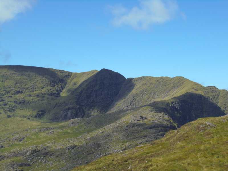
Picture: the Stumpa Duloigh massif from Broaghnabinnia
Stumpa Duloigh is part of a thrilling circuit which is currently beset by access issues. As of June 22 there is no access from L Reagh N (V82184 81255). The ridge which incorporates SD is still accessible however and is well worth it if you’ve time for a longer drive. It lies high above a fine, steep-sided corrie and is splendidly isolated, challenging and commands great views of the Reeks, Glenbeigh and Dunkerron hills and over to Beara. The steepness to the N needs utmost care in bad weather.
SW. Park at Ballaghbeama Pass BallBeam (V75451 78103). N on rough ground to Knockaunanattin W top, then go E and ENE to K’anattin. Head E to the SW top of SD before climbing the v steep SW ridge to SD top. 2.5 hrs
SE. Park at Lough Fada N (V80804 78058) - room for 2/3 cars. Walk up to the pass, climb the fence and go for it! By that I mean head roughly N and aim to meet ridge near A (V80221 79013). Then it’s a steep, tracked ascent to the summit plateau. 2 hrs
N. Park at the head of the Bridia Valley at approx B (V77855 81463). Head for C (V79182 82230) and follow the fenceline to Broaghnabinnia and descend to the S (do not aim directly for SD as dangers await if you descend W of S). After reaching the col, climb steeply on an ever-narrowing ridge and at SH 776 it’s best to stay away from the edge of the corrie – instead veer to the W for a safer but still steep climb to the top. 3hrs+
No tracks on MV although track/3098 can be adapted, track/4395 can be used for Broaghnabinnia from NW and track/3287 gets you to SD SW top.
Access Issue for track into Lough Reagh in the Black Valley
by ahendroff
11 Sep 2020
It has come to my attention of an access issue in the Black Valley on the Iveragh Peninsula. This affects Route 16: Gearhameen Circuit in the Killarney to Valentia Island - The Iveragh Peninsula guidebook and Walk 16: High-level Circuit of the Gearhameen Valley in The Dingle, Iveragh & Beara Peninsulas. For more information on these guidebooks and special offers, visit the online bookshop here.
Landowners have unfortunately closed off access at the start of the route (L Reagh N (V821 813) D) that follows a trail leading southwest that meanders around the edge of Lough Reagh.
As a result of this, please consider the following alternative - more information here: www.adrianhendroff.com/access-issue-in-the-black Linkback: mountainviews.ie/summit/55/comment/20882/
Read Less
Read More
Picture: Point 776 in the centre
Point 776 (Stumpa Duloigh)
by Onzy
10 Sep 2015
Captain Vertigo and I have posted tracks separated by only a few days, covering similar ground and centred around Stumpa Duloigh. My track (3080) took an anti-clockwise direction while the Captain (3108) proceeded clockwise. Consequently we approached Stumpa Duloigh, and most significantly point 776 (D (V78796 79545)) immediately north of the summit, from different directions, with me ascending and Captain Vertigo descending. For the Captain, point 766 was very much the crux of the route (leaving out the ascent of Mothaillin…). In my case, on reaching E (V78722 79635), where the Stumpa Duloigh ridge meets the rise to point 776, I faced some infeasibly steep ground which was horribly exposed to the 300m plunge into Lough Duff. However, having the benefit of sight lines, I was able to detour west onto less steep ground around the obstacle. What remains is still steep, but without the sheer horror of the direct line. Approaching from point 766, without a clear view of the obstacle, the Captain faced descending onto this steep ground blind and from above – not a nice thought.
A couple of messages here; firstly it is probably safer to take in point 776 from the north; as Captain Vertigo has shown eloquently, a descent to the north is not for the faint hearted – whereas my experience from the other direction, was steep but unremarkable in the context of these amazing hills. And secondly, whichever direction you are approaching from it is best to keep more west of the line from 776 to the col to avoid the very steep ground at E (V78722 79635). Linkback: mountainviews.ie/summit/55/comment/18306/
Read Less
Read More
kevin dockery on Stumpa Dúloigh
by kevin dockery
15 Nov 2008
On Fri.14/11/08 I parked at a bridge approx 400mts. north of Lough Reagh in the Black Valley. I followed a rough track to the edge of the lake and then started the steep ascent to Broaghnabinnia (745metres).Weather conditions were very poor with wind,light rain and mist despite the fact that the forecast was very good for the day.I descended with care in a south west direction to a gap before the steep ascent of Stumpa Duloigh.From the summit i followed a fence in a south west direction to a gap before the easy ascent to Stumpa West Top (663mts).I retraced my steps back to Stumpa Duloigh.At this stage there was no more climbing involved for the rest of the walk.I estimate that the total height climbed from the start was 4,200 feet.My aim was to proceed along the south east shoulder of Stumpa Duloigh for approx 1 km. before veering north east down the steep slopes towards Lough Reagh.Throughout the day I frequently consulted my map and compass because of the foul weather.I descended the steep slopes alright but unfortunately ended up in the wrong valley between Knocklomena and Stumpa which was a bit of a shock to me.Luckily i knew where i was as Lough Brin was only 1 mile to the west so I didn't panic.I was faced with a 15 mile road walk in the dark back to the Black Valley.At stage it was dusk but I had a torch,food and water with me. This narrow deserted road followed the Owenreagh River for approx 8 miles.Fortunately after walking 7 miles on the road I got a lift from 2 kind and considerate residents of the valley.They insisted on treating me to tea and sandwiches in their home and drove me back to my car.My advice is to leave Stumpa and the other summits mentioned for a dry clear day.Leaving out the road walking I found this to be a very interesting and tough walk. Linkback: mountainviews.ie/summit/55/comment/3438/
Read Less
Read More
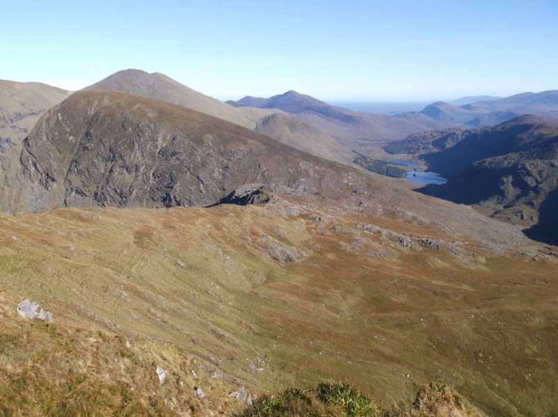
Picture: Bruach na Binne and the Black Valley towards Purple Mtn and Torc
Challenging Walk in Glorious Backcountry
by ciarraioch
4 Nov 2012
Followed Adrian Hendroff's suggested route per his excellent 'The Dingle, Iveragh & Beara Peninsulas' from the end of the Black Valley. We parked at F (V812 821) on the obvious layby just beyond the bridge. Crossed back over the bridge passing through the gate on the RHS and following the track through a gated sheep pen to the side of Loch Riabhach/Roisín Lake. The track brings you to the remains of a very early Christian settlement along with an Ogham stone. Departing somewhat from Adrian's route, we struck off up the northern valley from this point and contoured along the southern slopes of Bruach na Binne, traversing the rough ground until we reached the col at Bearna Seilg, the Gap of the Hunt. No eagles on this occasion, we struck off left along the ridge. Very slow going until this point due to rough ground and rock benches on the initial kilometer or so of the ridge. The ridge narrows giving fantastic views down into the Braighde Valley, across to Corrán Tuathail and down back along the Black Valley to the Purple Mountain, Torc and the Plains beyond. Further along this axis, the distant Galtees were clearly visible on the day as well as Mount Hillary near Mallow and the faint outline of the Knockmealdowns. I thought I could make out Slievenamon just to the right of the Galtees, but this may have been wishful thinking! The ridge brings one to the narrow col just before the very steep and dangerous looking stretch to the first summit. Mindful of the 2002 tragedy, we avoided this by following the sheep path slightly to the right and then circling around from the back. Still a bit steep and slightly exposed but presumably a lot safer than a straight ascent. The first and most obvious summit though not actually the high point is the more satisfying vantage point and here also lies the plaque to the unfortunate walkers. From this point it is a simple walk across to the real summit. We returned by Cnoc na Bríde following Adrian's instructions. Glorious country. For experienced hill walkers only. Six hours overall. Linkback: mountainviews.ie/summit/55/comment/14858/
Read Less
Read More
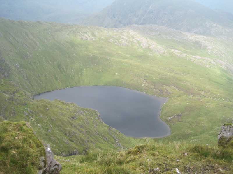
Picture: Lough Duff from Stumpa Dulaigh SE
Great Summit, remote, not busy
by Val Jones
6 Sep 2019
Climbed Stumpa Dulaigh on a Saturday, August 2019. Parked as described at B and did the anti clockwise circuit. Didn't do Broaghnabinnia or Knocknabreeda. Starting off getting up out of the valley was the toughest. It got easier from the col with Broaghnabinnia along the ridge, maybe we were just warmed up. The climb up to where the memorial plaque is was steep but as descibed, going left, it wasn't particularly dangerous. Great views of the reeks from the summit, and to the east, but the clouds were gathering from the west. Returning around the south was easy going at first but got tougher and wetter. We decided to descend from the col just before Knocknabreeda, initially was OK but got very steep and trisky to negotiate around some of the crags. We didn't meet anyone else on the mountain, only the farmer at the end by Lough Reagh Linkback: mountainviews.ie/summit/55/comment/20645/
Use of MountainViews is governed by conditions and a privacy policy.
Read general information about the site. Opinions in material here are not necessarily endorsed by MountainViews.
Hillwalking is a risk sport. Information in comments, walks, shared GPS tracks or about starting places may
not be accurate for example as regards safety or access permission. You are responsible for your safety and your permission to walk.
See the credits and list definitions.


 Our Facebook page.