This website uses cookies, which are small text files that the website puts on your device to facilitate operation. Cookies help us provide a better service to you. They are used to track general user traffic information and to help the website function properly.
Feature count in area: 25, all in Kerry,
OSI/LPS Maps: 70, 71, 78, EW-DC, EW-DE, EW-DW
Highest Place: Beenoskee 826m
Starting Places (34) in area Central Dingle: Anascaul Village, Annascaul Lake, Ballyduff Grave Yard, Brandon Village, Cloghane Community Centre, Conor Pass, Doonore South, Doorah, Dromavally Mountain SE, Emlagh Cross, Emlagh Wood, Farrannakilla School, Glan Mountain, Glanteenassig Lane, Glanteenassig Wood CP, Glennahoo River, Hostel Cloghane Village, Killiney R560 Junction, Kilmore Lodge, Lios Pole Church, Lisduff Rath, Lough Camclaun, Lough Caum, Lough Doon CP, Lougher, Maum Cross, Maumnahaltora Cross, Minard Beach, Mullaghveal Farm, Owenascaul Estuary, Pedlars Lodge, Pilgrimage Trail Owenmore River, Sauce Creek Walkway Dingle Way, Teerbrin
Summits & other features in area Central Dingle: Cen: Annascaul Lake West: Cnoc na Bánóige 641.6m, Cnoc na Bánóige North Top 447.6m, Knockmulanane 593.2m, Knockmulanane West Top 563.5m Cen: Dromavally: Cummeen 477m, Dromavally Mountain 552m, Knocknakilton 423m N: Annascaul Lake North: Coombane 610m, Beenatoor 592m, Beenoskee 826m, Stradbally Mountain 798m N: Carrigdav: Carrigadav 240m N: Fermoyle: Farrandalouge 144m S: Annascaul: Beenmore 252m, Brickany 374m, Knockafeehane 301m, Knocknanacree 286m W: Ballyduff: Slievenalecka 458.4m, Beenbo 476.7m, Slievenagower 485.8m W: Slieveanea: An Cnapán Mór 649m, Knockmoylemore 493m, Croaghskearda 608m, Slievanea 628.7m, Slievanea NE Top 670.7m
Note: this list of places may include island features such as summits, but not
islands as such.
Beenbo, 476.7mHill Gob an Iolair A name in Irish,
Place Rating ..
(Ir. Gob an Iolair [OSI], 'beak of the eagle'), Kerry County in Munster province, in Carn Lists, Gob an Iolair is the 644th highest place in Ireland.
Grid Reference Q54541 07456,
OS 1:50k mapsheet 70 Place visited by: 58members, recently by: maoris, chelman7, Oscar-mckinney, Jai-mckinney, Carolyn105, Moses, John.geary, mh400nt, JohnAshton, jackos, Fergalh, peter1, marcel, mountainmike, Ulsterpooka
I visited this place: NO (You need to be a logged-in member for this.)
Longitude: -10.12825, Latitude: 52.200166, Easting: 54541, Northing: 107457,
Prominence: 48.1m, Isolation: 0.6km ITM: 454523 607511 Bedrock type: Cross-bedded sandstone, (Coumeenoole Sandstone Formation) Notes on name: Since Beenbo is clearly a separate name (probably from Ir. Binn Bó, 'peak of the cow'), it seems likely that it is the true name of the summit, while Gob an Iolair applies originally to the sharp point just N of the summit.
Short or GPS IDs, 6 char: Beenbo, 10 char: Beenbo Linkback: https://mountainviews.ie/summit/535/
Gallery for Beenbo (Gob an Iolair) and surrounds
Summary
for Beenbo (Gob an Iolair):
Northern summit of a wild Dingle plateau.
Summary created by simon3, jackill
2015-07-03 09:22:15
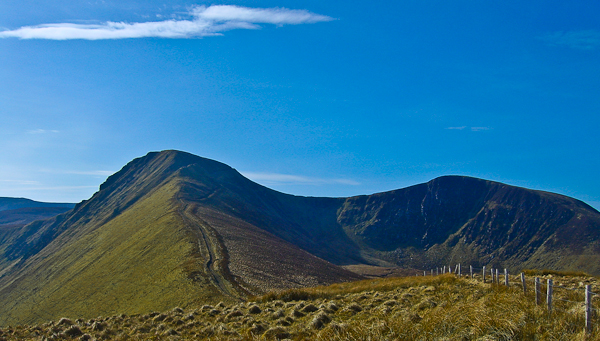
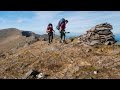
Picture: Beenbo ahead
Park at Ballyduff graveyard, BlDuff Grv (Q54076 10104), room for 10 cars.
Walk back towards the R560 from the graveyard and turn right. Walk around 500m along the road and cross the bridge over the Glennahoo River. Take care while walking along the R560 as it is a busy road with no verges. After crossing the bridge, continue along the R560 for another 300m. Leave the R560 and turn right into a track at A (Q54600 10350). There is an old farmhouse with dormer windows and a sloped flat roof extension at the track entrance. Continue south-eastward for around 150m along this track to reach a T-junction.
Turn right there and follow a lane southwards to Maghanaboe at the head of the valley. The Glennahoo River twists and turns along the valley floor to the right. The narrow valley, some 3km long, is flanked by a sweep of steep slopes clothed with banks of scree.
Note: We no longer recommend going on the ridge immediately south of the graveyard because of access issues.
If Slievenagower was good, Beenbo is even better endowed on the views front, with a fine ridge descending northwards & the deep cut Glennahoo to the east making this a fine summit.
It is clear that a round can be made from the north of these hills, with the track giving easy access up Beenbos' north ridge to Slievenagower and then rough ground out to Slievenalecka, making a fine circuit from, say the carpark for the trail round Loch an Duin? Investigation needed!
From Beenbos summit we descend south, crossing a fence and then a stream before climbing up to Banoge North N Top.
Potential access problem on the approach from Baile Dubh/Ballyduff graveyard near Cloghane. On 12 May 2012, followed Adrian Hendroff's route as per his excellent 'The Dingle, Iveragh & Beara Peninsulas'. This would appear to be the same access route as outlined in the Short Summary created by jackill above. Anyway, after following the road uphill from the graveyard, taking the right fork, and going through the rusty gate per instructions, we came across the following sign on the second gate further in, saying 'Private Property - No Walkers'. It was a temporary affair, just a printed A4 sheet in a plastic pocket. Being reluctant to turn back at this stage, we scaled a fence into the adjoining field and continued from there. For all we knew, this could also have been owned by the individual who put up the sign. Further up the mountain, we met a sheep farmer who was quite friendly, but neither we nor he mentioned the sign.
Lovely little mountain with a nice sharp ridge to a flat summit, great views across to Mount Brandon and its paternoster lakes and across to Loop Head in County Clare. Linkback: mountainviews.ie/summit/535/comment/6801/
Read Less
Read More
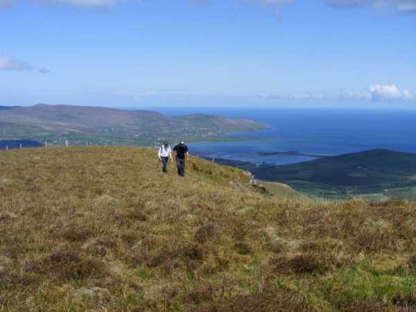
Picture: Uninspiring top, great descent to the north.
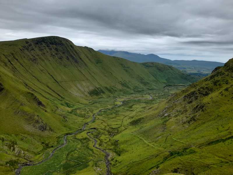
Great views of Glennahoo Valley
by Colin Murphy
2 Mar 2015
Beenbo was the final stop on a N-S trek starting at Lough Anscaul and taking in Knockmulanane, Cnoc na Bánóige, Banoge North N Top and Slievenagower, Having endured a fairly bleak five hours of high winds, rain and near zero visibility the descent from Beenbo offered virtually the only views of the day - the meandering Glennahoo River winding its way through a steep valley over three km long. Unfortunately it was still too misty to get any sort of decent shots - but it is a sight to behold. Beenbo summit itself is a heathery mound with no markings. Linkback: mountainviews.ie/summit/535/comment/17868/
Read Less
Read More
Picture: Beenbo (left) & Beenatoor (right) from the south
Picture: Beenbo and Glenahoo looking north from Macha na Bo
Glaciated valley to east
by Bunsen7
29 Jul 2022
It would be great if access to the north of Beenbo could be agreed as a lovely loop walk taking in Glennahoo (Gleann na hUamha -valley of the cave) and back down to An Baile Dubh would be possible.
As it stands there is access to Glennahoo but only via the track to the east of the river and thence to the plateau.
The track up from the head of the glen is interesting, there are some remnants of famine era homesteads in the glen, there are some deeply incised streams tumbling down the head of the glen, perhaps they enclose the cave the Irish name seems to refer to.
I noticed a couple of plaques dedicated to fallen hillwalkers along the track. A sheep farmer was shearing on the day of my visit and some litter in the vicinity of the work somewhat detracted the overall ambience but it is a place worth seeing. The farmer smiled and waved so no problem with access, though this was further in the glen. The initial track in from the sign on the main road is very overgrown, so bring insect repellent and perhaps a machete in late summer! Linkback: mountainviews.ie/summit/535/comment/23597/
Use of MountainViews is governed by conditions and a privacy policy.
Read general information about the site. Opinions in material here are not necessarily endorsed by MountainViews.
Hillwalking is a risk sport. Information in comments, walks, shared GPS tracks or about starting places may
not be accurate for example as regards safety or access permission. You are responsible for your safety and your permission to walk.
See the credits and list definitions.


 Our Facebook page.