Donation Request 2024

DONATE
Members and Supporters, the MountainViews Committee requests your help to meet the costs of the website and of other activities such as insured events or publications.
You do not have to be logged in to donate.
Features
Nearby features appear when you click the map.
Declutter tracks on map.
Place Search
Video
X
Pub: by
Cooley Mountains Area , N: Cooley North Subarea
Feature count in area: 12, all in Louth, OSI/LPS Maps: 29, 36, EW-CLY
Highest Place: Slieve Foye 587m

Starting Places (24) in area Cooley Mountains:
Annaloughan Loop Walk CP, Beck's Lane, Cadger's Bridge, Carlingford Car Park, Carlingford Greenway, Clermont Junction, Clermont Pass Bridge, Corna Mucklagh House, Deserted Village, Feede South, Flagstaff Viewing Point, Foxes Rock SW, Glenmore Tain Way, Grange Cross, Long Woman's Grave, Lower Faughil Road, Slieve Foye Viewing Point, Slievefoy Forest CP, Slievenagloch N, Spellickanee Mid, St Oliver's Park, The Ben Rock, The Lumpers, Two Mile River CP

Summits & other features in area Cooley Mountains:
N: Cooley North: Anglesey Mountain 421m, Carnavaddy 475m, Clermont 444m, Clermont Carn 510m, Clermont Carn NE Top 448m
S: Cooley South: Barnavave 350m, Slieve Foye 587m, Slieve Foye North-West Top 548.1m, Slievenaglogh 310m, The Eagles Rock 530m, The Foxes Rock 404m, The Ravens Rock 457m

Note: this list of places may include island features such as summits, but not islands as such.
Rating graphic.
Carnavaddy, 475m Hill Carn an Mhadaidh A name in Irish,
Place Rating ..
(Ir. Carn an Mhadaidh [LL], 'cairn of the dog'), Louth County in Leinster province, in Carn Lists, Carnavaddy is the 649th highest place in Ireland.
Grid Reference J11309 13836, OS 1:50k mapsheet 36
Place visited by: 149 members, recently by: Carolineswalsh, Jai-mckinney, Oscar-mckinney, childminder05, Dee68, aburden, annem, archmeister, livelife2thefull, Andy1287, MickM45, Bunsen7, Carolyn105, Kirsty, atlantic73
I visited this place: NO (You need to be a logged-in member for this.)
Longitude: -6.301285, Latitude: 54.062418, Easting: 311309, Northing: 313836, Prominence: 80m,  Isolation: 2.3km
ITM: 711202 813921
Bedrock type: Undifferentiated, or layered gabbro 1-4, (Layered Gabbro)
Notes on name: The summit cairn is indicated as an antiquity on the Discovery map but the summit itself is nameless. The name Carnavaddy is given on the Táin Way map guide. Carrickrawor (An Chreig Ramhar [LL]), Slievetrasna, Slievestucan and the Castle are marked as satellite peaks or slopes of this mountain. Corrakit (Corr an Chait) is a townland to the east, on the north side of the Windy Gap. [OSI]
  Short or GPS IDs, 6 char: Crnvdy, 10 char: Carnavaddy

Linkback: https://mountainviews.ie/summit/531/
Gallery for Carnavaddy (Carn an Mhadaidh) and surrounds
Summary for Carnavaddy (Carn an Mhadaidh): Bran
Summary created by Peter Walker, Trailtrekker, paddyhillsbagger, wicklore 2015-04-27 07:15:13
            MountainViews.ie picture about Carnavaddy (<em>Carn an Mhadaidh</em>)
Picture: Carnavaddy from Feede Mountain to the west
The most popular approach to this hill by locals is from the West, parking at either Cadger (J09410 13490) or Ben Rk (J09190 14294). There are tracks leading up the Poc Fada route (the yellow stones) and it can approached directly or by taking in Clermont Cairn first.

From the south there is room for one car at SpellkNee (J134 117) along the minor road to the SE of Carnavaddy. Cross the stile here and follow the Tain Way trail across the open hillside until it ends at a T-Junction. Turn right and follow another trail to the base of the slope up to the summit of Carnavaddy.

From the north, Carnavaddy can be approached via Clermont Carn. A minor road crosses the saddle between Clermont Carn NE Top and Clermont Carn at Clermt Jn (J102 163). Another minor road leads from the saddle up to Clermont Carn, from which there is a distinct broad track running directly to Carnavaddy. There are a number of wet areas to be negotiated. This leg of the walk is approx 2.5K, necessitating some long drops and equally long rises on to spot heights IA (J10434 15374) & IB (J10674 14847).

From the East, Carnavaddy can be accessed from the Long Womans Grave at LgWom Gr (J130 138). There is parking for 6 cars at this spot. Tracks lead up the steep but short climb gaining the shoulder of the hill where the walking trail guides you to the summit.

Carnavaddy is home to a huge cairn, reputedly the burial place of Bran, Fionn mac Cumhaill's faithful hound.
Linkback: mountainviews.ie/summit/531/comment/5290/
Member Comments for Carnavaddy (Carn an Mhadaidh)
Comment create / edit display placeholder

            MountainViews.ie picture about Carnavaddy (<em>Carn an Mhadaidh</em>)
A Legends Playground
by Trailtrekker 9 Mar 2012
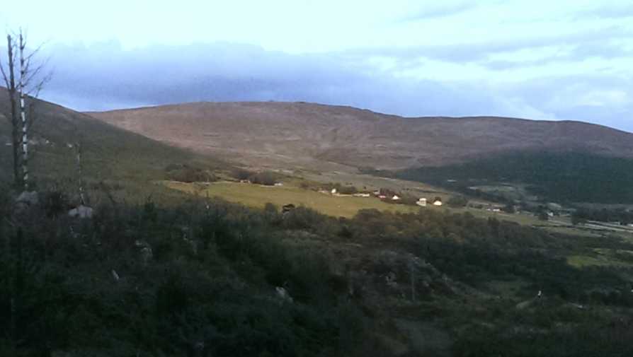
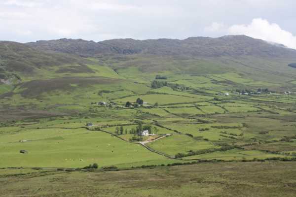
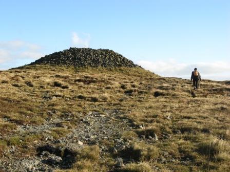
Carnavaddy holds a special place in my heart, possibly because it was one of the first peaks I ever conquered, but more likely for the fact that I believe it provides one of the finest views in the Cooley mountains and can be part of a truly Legendary walk! Only one previous commentator has fleetingly referred to it, but this mountain plays an integral part in that most ancient of mountain sports, the poc fada. The yellow stones that many have mentioned, but none have explained, mark out the route of this great annual GAA event. The route starts in Annaverna, following the well marked track that features on the OS map up Clermont Cairn, before taking a sharp right turn to head for Carnavaddy. From here the route turns back down into the valley to form a triangular walk. The purists will no doubt pour scorn on this horrendous defacing of one of our hills. In this instance I think it can be justified, as they mark out the playground that Cuchullain himself once played in! They do effectively act as a way marking which I myself have followed in thick fog (Note: I will still always have map, compass and gps with me in case I somehow got lost).

My favourite route for this hill starts with parking up at Cadger (J09410 13490)
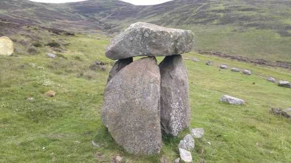
. There is room for about three cars here, there has been a DNG sign outside this house for well over a year now, look out for it. From here you head for the track in front of you that goes over a small concrete bridge, you will cross a gate after about 200 metres before starting the ascent along a track to the right of a stone wall. As you rise you will notice a stream in a deep gully to your right and stone alignments in front of you with the smallest damn Dolmen I have ever seen! The area is worth a look, so head over and investigate. From here you are looking out for the yellow stones heading off in a south easterly direction, which you follow all the way to the summit. The route crosses a couple of gullies, the largest of which poses the entrants to the poc fada the particular quandary of lay up short, or try and carry it!

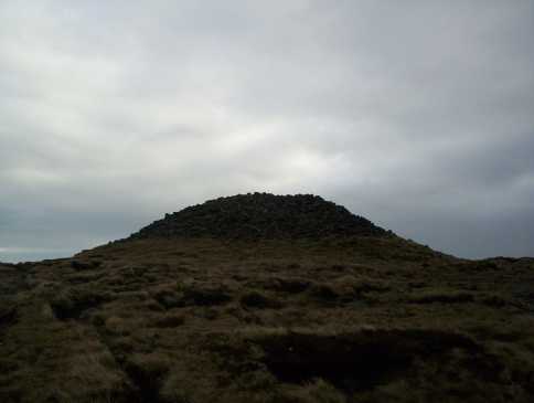
Once at the summit I will usually head for Clermont Cairn before following the track back down to Annaverna. I have covered this route in 2 hours 20 when travelling at a very strong pace, but 3 hours would be the average time for this anti clockwise reverse circuit of the poc fada.

Another good route over this hill, that has not been mentioned yet, is from Clermont Pass Bridge Clermt Ps (J118 154). Two cars needed for this route. Park up in area beside the bridge, enough room for a few cars. Cross the nearby stile and head across open country in a south westerly direction to the summit. From here follow the tracks in a south easterly direction to the edge of the forest and on to castle mountain, before rejoining the Tain way and descending down to a lumpars pub Lumpers (J100 108), where I would recommend sampling some of the product from the local distillery. Linkback: mountainviews.ie/summit/531/comment/6709/
Read Less
Read More

            MountainViews.ie picture about Carnavaddy (<em>Carn an Mhadaidh</em>)
Picture: View across the valley to Slieve Foye from Carnavaddy
wicklore on Carnavaddy
by wicklore 17 Jun 2009
Most contributors seem to have approached Carnavddy from the north. I found an alternative easy approach from the south that takes advantage of straightforward tracks, and is accompanied by fine views across to Slieve Foye all the way.

I parked at SpellkNee (J134 117) along the minor road that approaches the Windy Gap to the SE of Carnavaddy. There is room for one car where the Tain Way leaves the road and crosses a stile onto the hillside. There are actually two stiles – one older wooden one, and a newer metal one obviously built as a part of the Tain Way. The metal one even has an image on it to show walkers how to climb over it! After having safely and successfully crossed the 3-step stile, I followed the track NW uphill. The views across to Foxes Rock, Ravens Rock and Slieve Foye are magnificent, particularly set against the green farmland below.

The track soon ends at a t-junction at C (J125 123). The Tain Way turns left, and leads off to an area marked on the map as The Castles. Judging by the amount of walkers coming and going that way it is a popular route. I turned right and followed the track another 1km or so to a point just past the 415m spot height at D (J119 137). Here the track sort of peters out, but at this point you are below the SE shoulder of Carnavaddy. By following my nose (and compass in the mixed weather) I picked my way up and over the sometimes rough ground to the summit cairn at E (J112 139).

When setting out to return by the same route I met four scramblers who aimed to drive over the steepest sections of rock and turf. Their wheels sprayed up dirt and loosened rock. I had also seen them earlier across the bog near The Castles and I got a feeling they were regular visitors to the area.

The return trip was under 2 hours, and was quite enjoyable. The underfoot conditions were mostly good, although there were some easily negotiated boggy patches here and there. This could be a good start/finishing point for a traverse from Anglesey to Carnavaddy. Certainly Carnavaddy and the Tain Way are very popular walking areas as there were people visible at all times. Linkback: mountainviews.ie/summit/531/comment/3861/
Read Less
Read More

            MountainViews.ie picture about Carnavaddy (<em>Carn an Mhadaidh</em>)
Picture: Carrickrawor Cairn
eflanaga on Carnavaddy
by eflanaga 12 Nov 2007
From Clermont Cairn (see for previous stage of walk) there is a distinct broad track with a good many yellow stone markers running directly on to Carrickrawor but the track does not appear to be shown on Mourne OS Sheet 29 (1:50000). The track itself is in good order for the most part but there are a number of wet areas to be negotiated. Hill-walkers, mountain-bikers and agricultural vehicles have taken their toll on parts of the track. This leg of the walk is quite long (approx 2.5K) necessitating some long drops and equally long rises on to spot heights IA (J10434 15374) & IB (J10674 14847). Eventually, the impressive and substantial cairn on Carrickrawor comes into view. The entire ridge walk is brought into clear relief from the summit area. Great views across to Dundalk on one side and Warrenpoint/Newry, Rostrevor & the Mournes on the other, with the remaining Cooley summits in the distance across the Windy Gap. Linkback: mountainviews.ie/summit/531/comment/2898/
Read Less
Read More

            MountainViews.ie picture about Carnavaddy (<em>Carn an Mhadaidh</em>)
Picture: The cairn which gives Carnavaddy its name
denise-vosges on Carnavaddy
by denise-vosges 19 Nov 2008
We climbed Carnavaddy and Clermont Carn on an October Sunday outing that combined 3 methods of transport: train, bike and shank's pony. Taking advantage of the Sunday tracker ticket which allows you to travel anywhere on NI Railways for a fiver, we got the 12 o'clock train from Belfast to Newry. Then a 15km cycle ride along Carlingford Lough to a point just opposite Narrow Water Castle and up the hill to Bavan. Here we hid our bikes and locked them and set off on foot, attacking Carnavaddy from the north. Clear views of the Mournes, Carlingford Lough and Dundalk bay were magnificent. The tranquillity of the scene was momentarily disturbed by some morons on quad bikes, who came in our directions especially to annoy us, but fortunately they hadn't enough fuel for more than one pass before being forced to descend the mountain. From here we headed NW to Clermont Carn, before descending the road back to Bavan, cutting off the big loop. We then pedalled back to Newry in time for the 18.10 train. If you get the 10 o'clock train from Belfast, you can fit even more into your walk! Linkback: mountainviews.ie/summit/531/comment/3451/
Read Less
Read More

val jones on Carnavaddy
by val jones 28 Sep 2007
I know this mountain as Carnawaddy, and as far as I know, that is what it is known locally as.
Perhaps that is the name of the big cairn at the summit, 'Carn a mhadra', which is the reputed burial place of Cuchulain's dog Bran.
There are some great rock features to the south and east of the summit, including a particularly interesting chasm as you go down towards the Windy Gap. Linkback: mountainviews.ie/summit/531/comment/2840/
Read Less
Read More
EDIT Point of Interest
text
Videos


Recent Contributions
x
Conditions and Info
Use of MountainViews is governed by conditions and a privacy policy.
Read general information about the site.
Opinions in material here are not necessarily endorsed by MountainViews.
Hillwalking is a risk sport. Information in comments, walks, shared GPS tracks or about starting places may not be accurate for example as regards safety or access permission. You are responsible for your safety and your permission to walk.
See the credits and list definitions.

OSi logo
OSNI/LPS logo
Open Street Map
(Various variations used.)
British summit data courtesy:
Database of British & Irish Hills