Members and Supporters, the MountainViews Committee requests your help to meet the costs of the website and of other activities such as insured events or publications.
Feature count in area: 45, all in Donegal,
OSI/LPS Maps: 11, 6
Highest Place: Croaghgorm 674m
Starting Places (22) in area Bluestack Mountains: An Leathchruach, Barnsmore Gap, Bensons Hill, Caldragh CP, Clogher South peak, Cruach Mhín an Neanta, Doobin, Eanybeg Water Bridge, Edergole Farm, Gaugin Mountain, Glennacree CP, Hillhead, Lough Finn West, Lough Magrath Beg NE, Lough Muck North, Meenaguse Lough, Sand Lough Forest Picnic Area, Scoil Náisúnta an Choimín, Sheskinlubanagh, Sruell Gap Farm, Sruell River Road, St Columbkilles Well and Altar
Summits & other features in area Bluestack Mountains: Cen: Reelan Hills: Altnapaste 364m, Gaugin Mountain 565m, Lacroagh 403m, Boultypatrick 429m, Croveenananta 476m, Croaghubbrid 416m, Croaghugagh 410m N: Fintown Hills: Aghla Mountain South Top 589m, Aghla Mountain 593m, Scraigs 426m, Croaghleheen 385m NW: Glenties: Cloghercor South 301m, Derkbeg Hill 332m, Drumnalough Hill 282m S: Belshade: Croaghgorm 674m, Croaghgorm South-West Top 597m, Croaghgorm East Top 594m, Ardnageer 642m, Ardnageer SW Top 626m, Banagher Hill 392m, Croaghbane 641m, Croaghgorm Far South-West Top 561m, Cronamuck 444m, Croaghbarnes 498.8m, Glascarns Hill 578.3m, Meenanea 435m SE: Barnesmore: Brown's Hill 496.4m, Cloghervaddy 402m, Croaghagranagh 440m, Croaghanirwore 546.1m, Croaghbrack 401m, Croaghconnellagh 523m, Croaghnageer 569.1m, Croaghnageer East Top 543.5m, Croaghnageer North-East Top 521m, Croaghonagh 451m SW: Eany Beg Hills: Binbane 453m, Binbane NE Top 439m, Lavagh Beg 650m, Lavagh More 671m, Binnasruell 505m, Carnaween 521m, Cloghmeen Hill 429m, Silver Hill 600m, Cullaghacro 476m
Note: this list of places may include island features such as summits, but not
islands as such.
Croveenananta, 476mHill Cruach Mhín an Fheannta A name in Irish,
Place Rating ..
Ir. Cruach Mhín an Fheannta [logainm.ie], 'the stack of the mountain pasture of the flaying’, Donegal County in Ulster province, in Carn Lists, Cruach Mhín an Fheannta is the 646th highest place in Ireland.
Grid Reference G94176 94737,
OS 1:50k mapsheet 11 Place visited by: 27members, recently by: Colin Murphy, dino, jlk, Wilderness, eamonoc, melohara, noucamp, markmjcampion, leader1, AntrimRambler, shaunkelly, madfrankie, Aidy, Fergalh, chalky
I visited this place: NO (You need to be a logged-in member for this.)
Longitude: -8.091339, Latitude: 54.800443, Easting: 194176, Northing: 394737,
Prominence: 221m, Isolation: 1km ITM: 594126 894727 Bedrock type: Graphitic pelite, thin psammite, marble, (Croaghubbrid Pelite Formation) Notes on name: The form Cruach Mhín an Fheannta from logainm.ie is supported by James O’Kane (Séamas Ó Catháin), who interprets it as 'the stack of the high field of the flaying' in his place-name survey of the parishes of Inishkeel and Kilteevoge. The Discovery map has a slightly different version: Cruach Mhín an Neanta, apparently 'the stack of the high field of the nettles'.
Short or GPS IDs, 6 char: Crvnnn, 10 char: Crvnnnt Linkback: https://mountainviews.ie/summit/528/
Gallery for Croveenananta (Cruach Mhín an Fheannta) and surrounds
Summary
for Croveenananta (Cruach Mhín an Fheannta):
An excellent vantage point.
Summary created by Harry Goodman
2013-08-22 19:41:48
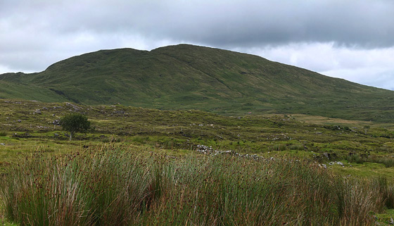
Picture: Croveenananta from the S.
Leave the R253 at A (G968 963) and take a minor road going S and then SW to LeathCrua (G93724 93563) some 5km along. Parking for several cars. Cross the road and walk N up a track which forms part of the Slina Finne waymarked way. Although the track is at times quite indistinct on the ground make for the col up ahead between Lacroagh and Croveenananta. On reaching B (G93588 94677) at the col turn right and climb up E initially crossing a lower top C (G93946 94734) before continuing on for another 150 metres to the ummarked grass coverd high point D (G94142 94713). Return by way of ascent or drop down around the SW flank of the hill to E (G93664 94239) to pick up the outward track of the Sli na Finne and go left back to the start.
Having recently walked the main Bluestacks ridge, starting at a point noted by others, I found myself with enough time to pick off CMN as well. Walked up Sli na Finne from the Reelan Valley, well marked but boggy long distance path to the west of the top, then picked up the ridge. Had to (carefully) cross one post and wire fence but that was the only obstacle.
The summit offered a good panorama of the main ridge climbed earlier in the day. Linkback: mountainviews.ie/summit/528/comment/4726/
Read Less
Read More
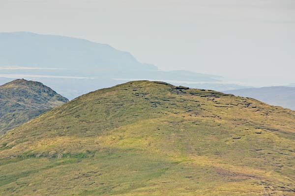
Picture: View of the summit from Gaugin.
Boggy top with sea views.
by simon3
11 Aug 2012
This is a picture of the summit area taken from nearby Gaugin showing the peat hags. Lacroagh is to the left and the broad summit in the background is Slievetooey above the coastline of Loughros More bay. Linkback: mountainviews.ie/summit/528/comment/14755/
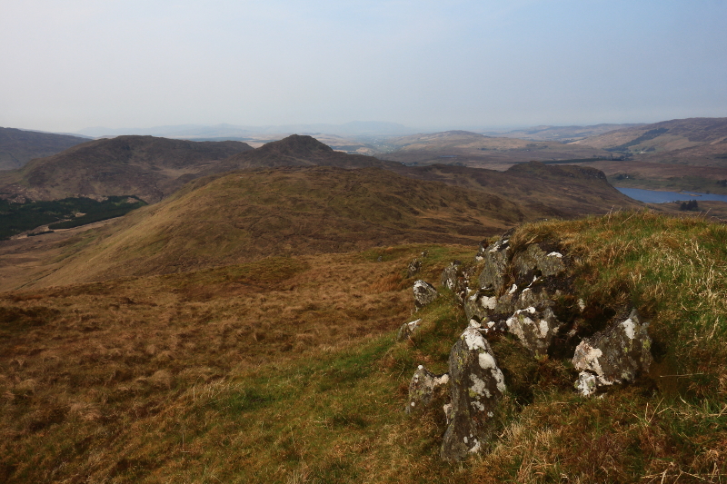
Picture: Looking towards the next 3 peaks on my walk.
A Small Wilderness
by Aidy
20 May 2016
The first of a four summit walk, proceeding to Lacroagh, Croaghugagh and Croaghubbrid. I started at Harry Goodman's point B, heading for the Croveenananta side of the col with Lacroagh, then turning east over a minor summit and on to the top. The route over the four tops is a great little walk, not too difficult or long, but with great views and the feeling of being in a really wild, isolated area. In addition to all the other views, I loved the new perspective down on Lough Fhia and the steep sided Croagh Hatain (a non MV hill). As usual in the Bluestacks, they do make you work a little, with some boggy stretches, and some deep heather to wade through. Seems to make it more satisfying somehow though. Linkback: mountainviews.ie/summit/528/comment/18537/
Read Less
Read More
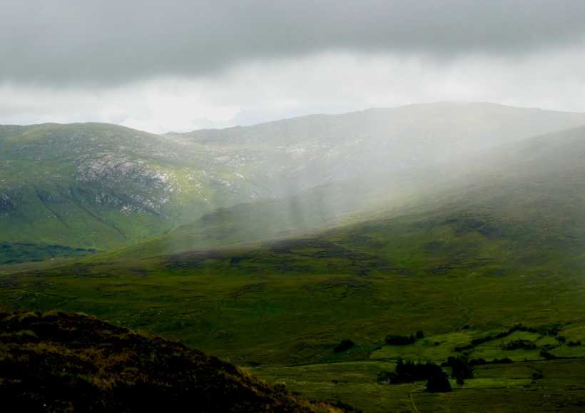
Picture: A thundery shower passing over the Reelin Valley.
Varied scenery - and weather.
by Colin Murphy
13 Jul 2023
On a day of wildly changing weather, one moment I enjoyed splendid views in all directions under sunny conditions, then the skies would darken and the heavens batter me from high, only for the sun to appear again 10 minutes later. It went from 22 deg C at the start of the walk to about 12 with a cutting wind on higher ground. Such are the pleasures and pains of hillwalking in Donegal! Linkback: mountainviews.ie/summit/528/comment/24004/
Use of MountainViews is governed by conditions and a privacy policy.
Read general information about the site. Opinions in material here are not necessarily endorsed by MountainViews.
Hillwalking is a risk sport. Information in comments, walks, shared GPS tracks or about starting places may
not be accurate for example as regards safety or access permission. You are responsible for your safety and your permission to walk.
See the credits and list definitions.


 Our Facebook page.