This website uses cookies, which are small text files that the website puts on your device to facilitate operation. Cookies help us provide a better service to you. They are used to track general user traffic information and to help the website function properly.
Feature count in area: 115, by county: Wicklow: 108, Kildare: 4, Wexford: 2, Carlow: 3, of which 1 is in both Wexford and Wicklow, of which 1 is in both Carlow and Wicklow,
OSI/LPS Maps: 28B, 55, 56, 61, 62, AWW, EW-DM, EW-LG, EW-WE, EW-WS
Highest Place: Lugnaquilla 924.7m
Starting Places (205) in area Wicklow: 1916 Memorial Car Park, Aghavannagh Ow Bridge, Aghowle Wood, Altidore Wood Entrance, Annacurra National School, Annalecka Bridge, Asbawn Brook L8350, Aughrim National School, Ballard Road, Ballinabarny Gap, Ballinagappoge Bridge Layby, Ballinagappoge Mountain Hairpin, Ballinagore, Ballinahinch Wood, Ballinastoe MBT CP, Ballinastraw South, Ballineddan Upr Fork, Ballinfoyle Upr Cross, Ballycoog, Ballycreen Brook Bridge, Ballycumber, Ballycumber Bridge, Ballycumber Lane, Ballycumber Wicklow Way, Ballylerane, Ballylow Bridge, Ballylusk Quarry, Ballymanus Lane, Ballymoyle Shooting Lodge, Ballynultagh Gap, Ballynultagh Lane, Ballyreagh Wood, Ballyross Forest, Ballysmuttan Long Stone, Baravore, Barnbawn South, Barranisky North, Barranisky West, Bohilla Land Roundabout, Bohilla Lane Mid, Boranaraltry Bridge, Bray Harbour, Brewel West, Brittas Bay North CP, Buckroney Sand Dunes CP, Bus Terminus, Camera Hill Track Cross, Castletimon Wood North, Clara Vale, Clone House Road, Clonegal, Cloon Wood Cp, Coate Bridge, Coolballintaggart Ledge, Coolbawn House Lane, Cransillagh Brook , Crone Wood CP, Crossbridge, Crossoona Rath, Cummer Wood South, Curtlestown Wood CP, Deputy's Pass CP, Derralossary Church, Derry River Bridge, Devil's Glen CP, Devil's Glen Wood, Djouce Wood Calary, Djouce Wood Lake, Djouce Wood Long Hill, Donard, Donnelly's Lane Car Sales, Drumgoff Forest, Dunranhill North, Dunranhill SE, Dunranhill South, Dwyer McAllister Cottage CP, Enniskerry, Fentons Pub, Fitzsimons Park GAA, unuseableFlemings Footbridge Glen Rd, Gap Pub, Gap Road, Glen Beach CP, Glen of the Downs CP, Glenbride Lane, Glenbride Lodge, Glencree Reconciliation, Glendalough, Glenealy GAA, Glenmacnass Tonelagee CP, Glenmalure Hostel, Glenmalure Lodge, Glenmalure Waterfall, Glenview Hotel, Gowle House, Great Sugar Loaf CP, Grove Bar, Heffernans Well Wood, Hill View, Hollywood Glen, JB Malone CP, Johnnie Fox Pub, Keadeen NE trail, Keadeen Trailhead, Kevins Way Footbridge, Kilbride Army Camp Entrance, Kilcandra South, Kilcommon View, Killalongford Wood, Kilmacrea Cross Roads, Kilranelagh House Gate, Kilruddery Car Park, Kilruddery Cottages, Kings River, Kippure Bridge, Kippure Estate, Kippure Transmitter Gate, Knickeen Cross, Knocknaboley Lane Leeraghs Bog, Knocknaboley Lane Stone Cottage, Knockrath Little, Knockree west, Kyle Loop North, Lackan Wood S, Lake Dr Fraughan Brook, Lake Drive, Lake Park Cross, Lake View Pub, Laragh Free Car Park, Laragh NSch, Lead Mines CP, Liffey Bridge, Liffey Head Bridge, Lough Bray Lower, Lough Bray Upper, Lough Tay North Viewing Point, Lough Tay Wicklow Way CP, Luglass Lane L97561, Lugnagun Track, Macreddin Village, Mangans Lane, Military Road Carrigshouk Hill, Military Road Inchavore River Nth, Military Road Inchavore River Sth, Military Road NW Lough Tay, Military Road Ballyboy Bridge, Military Road Cloghoge Brook, Military Road Croaghanmoira, Military Road Fananierin, Military Road LaraghWicklow Way, Military Road Slieve Maan, Monspolien Bridge, Moortown House, Mountain Rescue HQ, Muskeagh Little Wood, Nahanagan Lough NE, Novara Avenue, Bray, Oiltiagh Brook Knickeen, Old Bridge Cross, Old Bridge Scouts , Old Wicklow Way entrance, Paddock Hill SE, Pier Gates CP, Powerscourt Waterfall CP, Putland Road, Quintagh East, Raheen Park CP, Raheenleagh East, Railway Walk CP, Rathdrum Railway Station, Rednagh Wood, Rocky Valley, Roundwood, Sally Gap, Sally Gap N, Seefin Trailhead, Seskin SE, Shankill Tributary Bridge, Shay Elliott, Sheepshanks Bridge, Shillelagh, Slievecorragh Track, Slievefoore South, Sraghoe Brook, St John's Church, St Kevins Chair, St Kevins Church, St Kevins Way R756, Stone Circle Bridge, Stookeen South, Stranahely Wood, Stranakelly Cross Roads, Tallyho, Templeboden, Tithewer, Tomcoyle Lower, Tomriland Wood, Toor Brook, Trooperstown Hill Access, Turlough Hill CP, Upper Lake CP, Vallymount GAA CP, Vartry Reservoir Upper, Zellers Pub
Summits & other features in area Wicklow: Cen: Glendalough North: Brockagh Mountain 556.9m, Brockagh Mountain NW Top 549.5m, Brockagh Mountain SE Top 471.7m, Camaderry East Top 677.3m, Camaderry Mountain 698.6m, Conavalla 734m, Tomaneena 682.4m Cen: Glendalough South: Carriglineen Mountain 456.6m, Cullentragh Mountain 510m, Derrybawn Mountain 476.1m, Kirikee Mountain 474.5m, Lugduff 653.2m, Lugduff SE Top 638m, Mullacor 660.7m, Trooperstown Hill 430m N Cen: Tonelagee: Carrignagunneen 561m, Fair Mountain 571.2m, Stoney Top 713.7m, Tonelagee 815.8m, Tonelagee E Top 668m, Tonelagee South-East Top 545.8m NE: Bray & Kilmacanogue: Bray Head Hill 238.9m, Carrigoona Commons East 242m, Downs Hill 372.9m, Great Sugar Loaf 501.2m, Little Sugar Loaf 342.4m NE: Djouce: Djouce 725.5m, Knockree 342.1m, Maulin 570m, Tonduff 642m, Tonduff East Top 593m, War Hill 684.8m, White Hill 631.1m NE: Fancy: Ballinafunshoge 480m, Kanturk 527.4m, Knocknacloghoge 532.4m, Luggala 593.3m, Robber's Pass Hill 508.9m, Scarr 640m, Scarr North-West Top 559.8m, Sleamaine 430m NE: Vartry: Ballinacorbeg 336m, Ballycurry 301m, Dunranhill 342m, Mount Kennedy 365.9m NW: Blessington: Carrigleitrim 408m, Lugnagun 446.2m, Slieveroe 332m, Sorrel Hill 599.5m NW: Mullaghcleevaun: Black Hill 602.2m, Carrigshouk 572.5m, Carrigvore 682.4m, Duff Hill 720.8m, Gravale 719m, Moanbane 703m, Mullaghcleevaun 846.7m, Mullaghcleevaun East Top 796m, Silsean 698m S: Aughrim Hills: Cushbawn 400m, Killeagh 249m, Moneyteige North 427m, Preban Hill 389m S: Croaghanmoira: Ballinacor Mountain 529.3m, Ballycurragh Hill 536m, Ballyteige 447m, Carrickashane Mountain 508m, Croaghanmoira 662.3m, Croaghanmoira North Top 579.5m, Fananierin 426m, Slieve Maan 547.8m, Slieve Maan North Top 546.1m S: Croghan Kinsella: Annagh Hill 454m, Croghan Kinsella 606m, Croghan Kinsella East Top 562.1m, Slievefoore 414m S: Shillelagh Hills: Lakeen 357m, Monaughrim 206m, Seskin 344m, Stookeen 420m S: Tinahely Hills: Ballycumber Hill 429.7m, Eagle Hill 296m, Muskeagh Hill 398.2m SE: Wicklow South East: Ballinastraw 284m, Ballyguile Hill 188m, Barranisky 280m, Carrick Mountain 381m, Collon Hill 238m, Kilnamanagh Hill 217m, Westaston Hill 270m W: Baltinglass: Ballyhook Hill 288m, Baltinglass Hill 382m, Carrig Mountain 571m, Carrigeen Hill 298m, Cloghnagaune 385m, Corballis Hill 258m, Keadeen Mountain 653m, Spinans Hill 409m, Spinans Hill SE Top 400m, Tinoran Hill 312m W: Cen Lugnaquilla: Ballineddan Mountain 652.3m, Benleagh 689m, Camenabologue 758m, Camenabologue SE Top 663m, Cloghernagh 800m, Corrigasleggaun 794.6m, Lugnaquilla 924.7m, Slievemaan 759.7m W: Donard: Brewel Hill 222m, Church Mountain 544m, Corriebracks 531m, Lobawn 636m, Slievecorragh 418m, Sugarloaf 552m, Table Mountain 701.7m, Table Mountain West Top 563m
Note: this list of places may include island features such as summits, but not
islands as such.
Mullaghcleevaun East Top, 796.0mMountain Mullach Cliabháin (mullach thoir) A name in Irish,
Place Rating ..
For origin of name, see Mullaghcleevaun., Stony Hill, Carraig Dúch, Wicklow County in Leinster province, in Arderin, Vandeleur-Lynam Lists, Mullaghcleevaun East Top is the 44th highest place in Ireland.
Grid Reference O08243 06707,
OS 1:50k mapsheet 56 Place visited by: 778members, recently by: jackos, rhw, MeabhTiernan, orlaithfitz, maoris, davidrenshaw, Prem, Lidia27, Carolineswalsh, Nailer1967, knightsonhikes, ToughSoles, muddypaws, FoxyxxxLoxy, Sonyalaw
I visited this place: NO (You need to be a logged-in member for this.)
Short or GPS IDs, 6 char: MlghEs, 10 char: MlghclEstT Linkback: https://mountainviews.ie/summit/52/
Gallery for Mullaghcleevaun East Top (Mullach Cliabháin (mullach thoir)) and surrounds
Summary
for Mullaghcleevaun East Top (Mullach Cliabháin (mullach thoir)):
Boulder strewn summit on ridge SE from Mullaghcleevaun
Summary created by simon3, Onzy, Sarkuns
2015-03-22 21:17:26
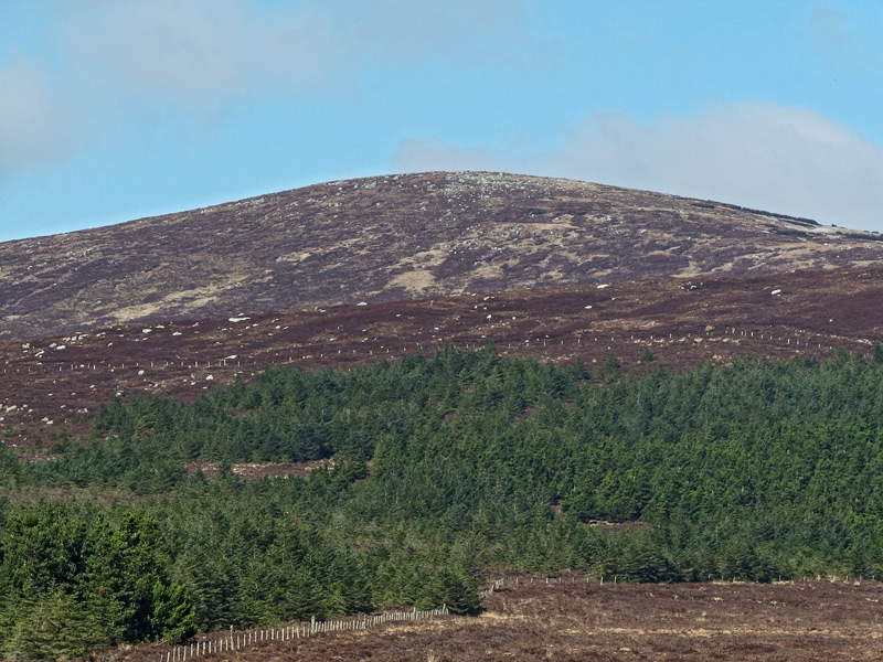
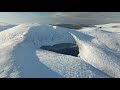
Picture: Mullaghcleevaun E Top from the east.
Mullaghcleevaun East Top is possible to reach from all sides. The easiest way is coming from Carrigshouk , and starting at CShouk (O1027 0525), or any other small gap along the Military road. (If it is a Bank holiday and promising weather come early because the places are limited, but on an ordinary day you will find a parking place easily).
Located in the middle of the mountain range this summit usually is visited as part of longer walking routes. With access from Stoney Top an obvious route taking in Tonelagee and its NE Top or from Duff Hill then extending the walk to Gravale and Carrigvore. Possible walking route from Blessington side, coming from Mullaghcleevaun.
Track 2370
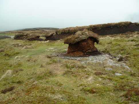
This part of Wicklow Mountains is famous for boggy terrain so hiking boots are a MUST. And if you don’t want to get your trousers dirty (because you will) I suggest gaiters. If the weather is rainy then the terrain will get only more and more difficult. But the reward for your dirty trousers will be 360 degrees view at the heart of Wicklow Mountains .
I recently hiked from Carraigshouk (parking at the little layby on the Military Road), we headed over Carraigshouk, and the across to Mullach Cliabháin (East) across the bog. The ground is extremely boggy here, gaiters are an absolute must, and the going is quite slow as you work your way around, and in and out of holes. Once you reach the slope of Mullach Cliabháin East, the ground firms up considerably, making the going a lot easier. When heading over to Mullach Cliabháin proper from the east top, it's best to stick to the higher ground on the shoulder that links both peaks. There are massive areas of exposed peat and eroded bog here, so it's best to try and avoid them. I headed back the way I came then. All in all this is a nice hike, and despite the boggy conditions it's really enjoyable, your efforts are constantly rewarded by stunning views. Tóin le Gaoth, Barr na Cuilleann, and Stoney Top, and Logalla, Cnocnacloghoge and Lough Dan from Carraigshouk. Linkback: mountainviews.ie/summit/52/comment/2232/
Read Less
Read More
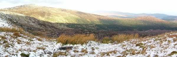
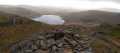
Picture: Carrigshouk rising to Mullaghcleevaun East Top
mneary34 on Mullaghcleevaun East Top
by mneary34
26 Nov 2005
I climbed Mullaghcleevaun East Top on 26th November 2005 in semi icey conditions. It makes an excellent circuit from Carrigshouk to East Top, then either include Mullaghcleevaun or else head directly for Barnacullian by staying on the ridge which can be very wet, and then on to Stoney Top and Tonelagee. Generally the area on the eastern side of the Barnacullian ridge is drier and has better ground for walking. A consideration to be kept in mind though is if you wish to head directly to Military Road at any time the later you leave it particularly after recent rain Glenmacnass River can be awkward to cross if you decide to do so before Glenmacnass Car Park. The attached photo shows the section from Carrigshouk rising to East Top. Linkback: mountainviews.ie/summit/52/comment/2068/
Read Less
Read More
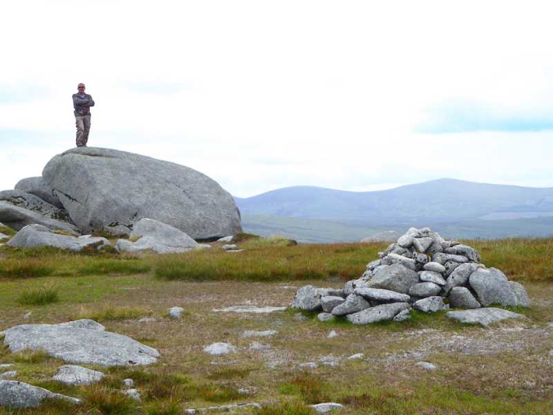
Picture: On the rocks
The high point of the climb
by Colin Murphy
26 Jul 2015
A technical point - I assume the summit of a top is the highest natural feature. In that case the cairn on Mullaghcleevaun East is not the actual high point, rather the large boulder a few metres away. So if you don't want to take any chances that you haven't been to the top...make sure you clamber up! Linkback: mountainviews.ie/summit/52/comment/18212/
Read Less
Read More
robespierre on Mullaghcleevaun East Top
by robespierre
5 Jan 2005
Mullaghcleavaun East Top is a really enjoyable hike from Blessington. We left from Blessington in the middle of a hurricane during the August Bank Holiday and took the road around the lake turning left at this pub and small shop up towards Black hill. We went over Black Hill and ascended Mullaghcleavaun which was hidden from us by some very thick fog. Visibility was down to about ten feet. The wind was howling and the hail started to come down quite heavily but the walk was pretty invigorating. The ground can’t get very boggy so picking out a path or following one of trails has its merits if the weather is inclement. Once we got to the top of Mullaghcleavaun the view was spectacular. A parting in the cloud threw the lakes open before as the afternoon sun shimmered briefly across them. The brief walk from there to the East-top is a pleasant jaunt down through a saddle past a few somewhat startled sheep through some heavily eroded bog.
We completed the circuits by walking around in the reverse direction around Mullaghcleavaun from the East Top to get back to our starting point. The first people we saw all day was on the way back to main road once we’d left the hills behind us. That may or may not be normal but it was very much virgin space that day. A most pleasant climb and with no forests in the vicinity we got a break from all those pesky flies. Linkback: mountainviews.ie/summit/52/comment/1403/
Use of MountainViews is governed by conditions and a privacy policy.
Read general information about the site. Opinions in material here are not necessarily endorsed by MountainViews.
Hillwalking is a risk sport. Information in comments, walks, shared GPS tracks or about starting places may
not be accurate for example as regards safety or access permission. You are responsible for your safety and your permission to walk.
See the credits and list definitions.


 Our Facebook page.