This website uses cookies, which are small text files that the website puts on your device to facilitate operation. Cookies help us provide a better service to you. They are used to track general user traffic information and to help the website function properly.
Feature count in area: 1, all in Waterford,
OSI/LPS Maps: 82
Highest Place: Cunnigar 5m
Starting Places in area Waterford Coast:
None for this area
Summits & other features in area Waterford Coast: Cunnigar 5m
Note: this list of places may include island features such as summits, but not
islands as such.
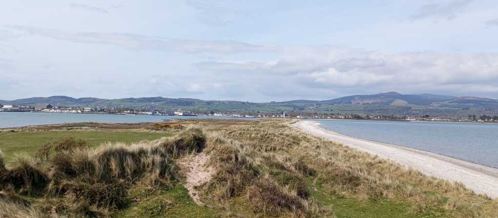
Cunnigar, 5mCoastal Feature Coinigéar A name in Irish,
Place Rating ..
, Waterford County in Munster province, in no lists Grid Reference X26900 91300,
OS 1:50k mapsheet 82 Place visited by: 6members, recently by: Fergalh, DeirdreM, Pepe, chelman7, Leatra, simon3
I visited this place: NO (You need to be a logged-in member for this.)
Visited this by kayak - it's just a short paddle across from Dungarvan. Alternatively, you can make a pleasant stroll of it by walking out along the spit that stretches into the bay from the coastline off the Dungarvan-Helvick road. Linkback: mountainviews.ie/coast/5141/comment/24149/
Read Less
Read More
Picture: View from Summit
Short trek to summit
by Fergalh
21 Apr 2024
Parked at A (X274 896) at car park. Walked along beach after traversing a small stream, the tide was out. Go past the wooden posts in the sea and than past the gorse. The high point is obvious when you are at the gorse and is around 200 metres north. A short climb leads to high point and there and walk back totals 4.5 Km Linkback: mountainviews.ie/coast/5141/comment/24183/
Use of MountainViews is governed by conditions and a privacy policy.
Read general information about the site. Opinions in material here are not necessarily endorsed by MountainViews.
Hillwalking is a risk sport. Information in comments, walks, shared GPS tracks or about starting places may
not be accurate for example as regards safety or access permission. You are responsible for your safety and your permission to walk.
See the credits and list definitions.


 Our Facebook page.