This website uses cookies, which are small text files that the website puts on your device to facilitate operation. Cookies help us provide a better service to you. They are used to track general user traffic information and to help the website function properly.
Feature count in area: 30, all in Galway,
OSI/LPS Maps: 37, 38, 44, 45, EW-CON, MSW
Highest Place: Tully Mountain West 306m
Starting Places (66) in area Galway Coastal Hill: Angler's Return, Aughrusbeg Lough, Ballyconneely, Ben Lettery Hostel, Brandy Harbour, Bridge St Clifden, Bundouglas Bay, Bunnageeha, Cashel Church, Cleggan House, Cloonsie Quay, Cnoc Mordáin, Connemara National Park Visitor Centre, Coorhoor Lough North, Dernasliggaun, Dogs Bay Beach, Emlaghdauroe Bridge, Emlaghdauroe South, Eragh Island South, Fee Lough SW, Foher, Furnace, Fuschia Lane, Glencoaghan River Bridge, Glenmore, Gort Mór, Gortdrummagh West, Illaunroe North, Illaunroe South, Inaghbeg Path, Inchamakinna, Inishlay, Inishnee Bridge, Kilkieran South West, Lettercallow School Road, Letterfrack Lodge, Lettergesh Beach, unuseableLettermullen Pier, Loch Chamais, Lough Anivan Bend, Lough Auna S, Lough Fee East, Lough Nafiddaun South, Lough Natawny, Lough Tanny, Mace Head, Muck Lough NW, Mweenish Cemetary, Nacreeva Lough, Nambrackkeagh Lough, Omey Strand, Owen na Baunoge River, Owengar Bridge, Ros an Mhíl, Ross Beach, Ross Point, Ross Quay, Roundstone, Skeaghatimull, Sky Road, The Big Ring, Tievegarriff, Toombeola Bridge, Water Reservoir, Water Tank, Water Tank Carna
Summits & other features in area Galway Coastal Hill: Ardagh 49m, Ardbear N 64m, Ballynew 84m, Barraderry 68m, Camus Eighter 72m, Camus Hill 96m, Cleggan Beacon 61m, Cuilleen 97m, Dawros More North 41m, Derryadd West 127m, Derrygimlagh West 41m, Derrylahan 49m, Doon Hill 67m, Faul 50m, Foher 223m, Gortmore 122m, Kilkieran 165m, Kinvarra 67m, Knockfin 49m, Lehid 53m, Lettercallow 109m, Mannin Beg 41m, Maum 62m, Murneen 73m, Murvey 81m, Rossaveel 48m, Shanboolard 85m, Streamstown East 79m, Streamstown West 103m, Tully Mountain West 306m
Note: this list of places may include island features such as summits, but not
islands as such.
Doon Hill, 67mCoastal Hill
Place Rating ..
Bunowen More is the townland name., Galway County in Connacht province, in no lists Grid Reference L59392 42601,
OS 1:50k mapsheet 44 Place visited by: 7members, recently by: Fergalh, Damian120, Colin Murphy, sandman, Jamessheerin, juliewoods, markmjcampion
I visited this place: NO (You need to be a logged-in member for this.)
Short or GPS IDs, 6 char: DnH67, 10 char: Doon Hill Linkback: https://mountainviews.ie/summit/5025/
Gallery for Doon Hill and surrounds
Summary
for Doon Hill :
Access issues
Summary created by Colin Murphy
2021-08-10 14:55:47
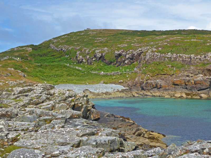
Picture: Fence visible in pic running across centre of pic.
As of August 2021 there are severe access issues with this small hill. Previously access could be had from Bunowen beach, just to the south, but halfway up you encounter a new, high barbed wire fence along with threatening warning signs. The historic castle is also apparently in private ownership so also remains inaccessible at this time.
Doon Hill is a small hillock, but is quite striking in that it occupies a pretty shoreline spot and because of the flatness of the surrounding area, may be seen from quite a distance. Linkback: mountainviews.ie/summit/5025/comment/23242/
Read Less
Read More
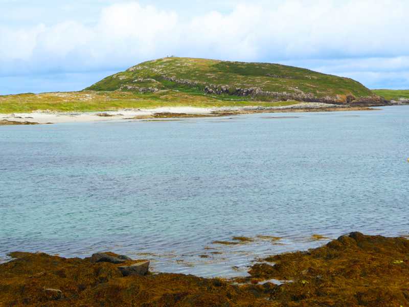
Picture: Summit Area.
Coastal Hill
by sandman
10 Jul 2017
During the time of Napoleon Bonaparte the powers in Dublin built a large number of signal towers all around the Irish Coast the ruins of one sits atop of Doon Hill .They were under British navy control with a lieutenant in charge and manned by farmers ,fishermen and merchants. Some 133 years later in the early days of World War Two the Irish government in order to protect its neutrality decided that a series of lookout posts would be built around the coast to monitor activity at sea. These posts were manned by soldiers who were called the Coast Watching Service. Today on Doon Hill sits a well preserved Irish military post set in the ruins of a British military post. Doon Hill on approach is very aesthetic, access is either along the foreshore from Bunowen pier or thru a private entrance located at A (L59951 43169) which seems to be the original entrance to the castle and on to the military constructed tract to the summit. Overlooking Bunowen Castle and the Quay views are fab all around. Linkback: mountainviews.ie/summit/5025/comment/19598/
Use of MountainViews is governed by conditions and a privacy policy.
Read general information about the site. Opinions in material here are not necessarily endorsed by MountainViews.
Hillwalking is a risk sport. Information in comments, walks, shared GPS tracks or about starting places may
not be accurate for example as regards safety or access permission. You are responsible for your safety and your permission to walk.
See the credits and list definitions.


 Add a Place Comment for Doon Hill


 Our Facebook page.