Members and Supporters, the MountainViews Committee requests your help to meet the costs of the website and of other activities such as insured events or publications.
Feature count in area: 20, all in Kerry,
OSI/LPS Maps: 70, 78, 83, EW-R
Highest Place: Coomacarrea 772m
Starting Places (24) in area Glenbeigh Horseshoe: Ballaghasheen Coilte, Ballaghasheen Pass Viewpoint, Cahernaman, Caunoge Boreen, Cloon Lough NE, Cloon Lough SE, Coolnahornan Bridge, Coomaclarig Bridge, Coomaglaslaw Outflow, Coomasaharn Lake, Coosatemple Cove, Coulagh Bridge Road, Drung Hill Layby, Gleensk Forest, Gleensk Viaduct, Glenbeigh Village, Lissatinnig Bridge Boreen, Lough Brista Wood, Lough Cappanlea OEC, Lough Caragh SW, River Behy Road, River Ferta Source, River Owroe Source, Roads Lough
Summits & other features in area Glenbeigh Horseshoe: Cen: Glenbeigh Horseshoe: Been Hill 651m, Beenmore 660m, Beenreagh 495m, Coomacarrea 772m, Drung Hill 640m, Keamconneragh 593m, Macklaun 607m, Meenteog 715m, Mullaghnarakill 665m, Teeromoyle Mountain 760m N: Glenbeigh: Callahaniska 219m, Coolroe 414m, Curra Hill 275m, Seefin 493m S: Caunoge: Caunoge 502m S: Knocknagapple: Colly 679m, Knocknagapple 466m, Knocknagapple NW Top 458m, Meenteog South-East Top 565m W: Mount Foley: Mount Foley 355m
Note: this list of places may include island features such as summits, but not
islands as such.
Seefin, 493mHill Suí Finn A name in Irish,
Place Rating ..
(prob. Ir. Suí Finn [PDT], 'Fionn's seat'), Kerry County in Munster province, in Carn Lists, Seefin is the 592nd highest place in Ireland. Seefin is the second most easterly summit in the Glenbeigh Horseshoe area.
Grid Reference V68787 89962,
OS 1:50k mapsheet 78 Place visited by: 67members, recently by: Krzysztof_K, Cobhclimber, Grumbler, eamonoc, Taisce, chelman7, glencree, John.geary, learykid, Bissboy, annem, JohnAshton, liz50, Fergalh, bandre
I visited this place: NO (You need to be a logged-in member for this.)
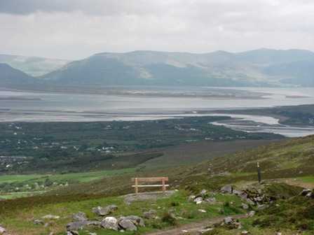
Picture: Those Kerry Way people think of everything
dbloke on Seefin
by dbloke
19 May 2008
Parked the car at Glenbeigh on the N70 by the sports ground as suggested by seán Higgisson in his book "A Walker's Guide to Killarney" - walk 13 Glenbeigh Circuit. Followed the road to the left past the church along the Kerry Way. As we didn't end up doing the complete circuit of Seefin we could have saved ourselves 20 mins of road walking by parking by the picnic bench at the junction of the lane at A (V666 900). You could squeeze 4 or 5 cars in easily here, but the middle ones would be hemmed in by the end ones. Follow the lane upwards and turn right over the small bridge. There is a Kerry Way sign here but it has become somewhat hidden by the surrounding flora. We only noticed it on the way down. Cross the style at the end of the lane and continue up the rough track. Towards the top there is another Kerry Way sign to reassure you that you are on course. Somebody has thoughtfully provided a bench so that you can sit down and admire the sign. Or the view over Rossbehy. At the top of windy gap turn left and follow the fence all the way to the top of Seefin, about 30 mins. There is a fair amount of bog around, but it was mostly very dry the day we were there. The worst of it is nearer the fence, so best to follow the sheep's advice and keep to their tracks over to the left. The summit is fairly flat and featureless and strewn with red rock. There is a trig point at the southern end and a small cairn made of white quartz to the north. Great views in all directions of the Reeks and Dingle. From the top of Windy Gap Coolroe is easily accessible; if it hadn't just started to rain and there wasn't a rush on to get back to catch the end of the golf. Beenreagh is not much further, and the really keen could keep going all the way to Drung. Linkback: mountainviews.ie/summit/480/comment/3110/
Read Less
Read More
Picture: Caragh Lake and Suí Finn
Caragh Lake panorama from Suí Finn
by glencree
20 Aug 2022
For a short circuit with excellent and extensive views over Caragh Lake, park at B (V70355 91048) with space for a few cars. Follow the Kerry Way track initially and then climb south westwards to the top of Suí Finn. To descend, follow the eastward spur skirting an area of mixed larch/spruce forest. Rejoin the road at C (V70579 89906), with a short road walk back to the car.
nice walk dbloke, particularly on a good day. You mention going on to Drung. I've done the route from Drung to the Windy gap and viewers might want to note that it is a full day's hike. So take water and something to eat. Linkback: mountainviews.ie/summit/480/comment/17715/
Use of MountainViews is governed by conditions and a privacy policy.
Read general information about the site. Opinions in material here are not necessarily endorsed by MountainViews.
Hillwalking is a risk sport. Information in comments, walks, shared GPS tracks or about starting places may
not be accurate for example as regards safety or access permission. You are responsible for your safety and your permission to walk.
See the credits and list definitions.


 Our Facebook page.