Cookies.
This website uses cookies, which are small text files that the website puts on your device to facilitate operation. Cookies help us provide a better service to you. They are used to track general user traffic information and to help the website function properly.
Features
Nearby features appear when you click the map.
Declutter tracks on map.
Place Search
Video
X
Pub: by
Breifne Area , W: Benbrack Subarea
Feature count in area: 14, by county: Fermanagh: 4, Cavan: 8, Leitrim: 3, of which 1 is in both Cavan and Fermanagh, OSI/LPS Maps: 26, 27, 27A
Highest Place: Cuilcagh 666m

Starting Places (15) in area Breifne:
Aghnacollia Lane, Bellavally Gap, Bencroy, Corneen Wind Farm, Corrawully Lane, Cuilcagh Boardwalk Trail, Dowra, Dowra Sweat House Lane, Glangevlin Cross, Gortalughany Viewpoint, Mullaghgarve Waterfall, Rock Road, Spa Well, Tulliniska Transmitters, Tully Lough

Summits & other features in area Breifne:
N: Cuilcagh Mountains: Benaughlin 370m, Benbeg 539m, Cuilcagh 666m, Mullaleam 424m
NE: Derrylin: Knockninny Hill 191m, Slieve Rushen 404m
SW: Iron Mountains: Bencroy 518m, Knockacullion 562m, Slieve Anierin 585m
W: Benbrack: Bartonny Top 411m, Benbrack 502m, Benbrack NE Top 496m, Benbrack West Top 463m, The Playbank 542m

Note: this list of places may include island features such as summits, but not islands as such.
Rating graphic.
Benbrack, 502m Mountain An Bhinn Bhreac A name in Irish,
Place Rating ..
(Ir. An Bhinn Bhreac [logainm.ie], 'the speckled peak'), Cavan County in Ulster province, in Arderin Lists, Benbrack is the 568th highest place in Ireland.
Grid Reference H10117 21600, OS 1:50k mapsheet 26&27A
Place visited by: 74 members, recently by: Carolineswalsh, Carolyn105, MickM45, trostanite, John.geary, AlanReid, srr45, Leonas_Escapades, annem, abeach, Grumbler, mountainmike, eoghancarton, ilenia, TommyMc
I visited this place: NO (You need to be a logged-in member for this.)
Longitude: -7.845966, Latitude: 54.143373, Easting: 210117, Northing: 321600, Prominence: 147m,  Isolation: 2.2km
ITM: 610064 821606
Bedrock type: Cyclothemic sandstone, siltstone, coal, (Lackagh Sandstone Formation)
Notes on name: A large group of rocks on the east side of Bellavally Gap are known as the Black Rocks or Maguire's Chair. This was the site of an assembly on 'Donagh Sunday', the last Sunday in July (MacNeill, 175-77). According to Dalton, the name has led to an erroneous belief that this was the inauguration site of the Maguires, and this is confirmed by MacNeill.
  Short or GPS IDs, 6 char: Bnb502, 10 char: Benbrac502

Linkback: https://mountainviews.ie/summit/450/
Gallery for Benbrack (An Bhinn Bhreac) and surrounds
Summary for Benbrack (An Bhinn Bhreac): Straightforward, and you get a bonus top on the way.
Summary created by Colin Murphy 2012-03-30 09:36:56
            MountainViews.ie picture about Benbrack (<em>An Bhinn Bhreac</em>)
Picture: Summit cairn with Derrynananta Lough on left and Cuilcagh in the distance
Approaching from the east along the R200, parking for several cars may be found on the right hand side in the Bellavally Gap at point A (H116 245). 100m further along is a short track heading south past a concrete farm enclosure. Leave the track after 100m where it swings east, and continue south crossing open moorland. Continue directly south for 500m when the ground begins to rise steeply, but is still walkable, and changes from heather/reeds to mostly grass, firm underfoot. A further 500m will take you directly to the summit of Benbrack NE Top (496m), which is marked by a cairn at point B (H113 236). From here, head SW for 1.2km until you reach the smallish Derrynananta Lough. The terrain is a mixture of heather and grass and may be traversed relatively easily, although you may encounter a few peat hags. Passing the lough on your right turn directly south where the ground begins to rise gently. Continue south for 800m to the broad summit area. A small cairn of sorts marks what is most likely the highest point at C (H102 216).
Linkback: mountainviews.ie/summit/450/comment/5209/
Member Comments for Benbrack (An Bhinn Bhreac)
Comment create / edit display placeholder

            MountainViews.ie picture about Benbrack (<em>An Bhinn Bhreac</em>)
Enormous landslide at summit - Avoid
by TommyMc 22 Jul 2021
The Anglo Celt newspaper has reported an "enormous" landslide earlier this month on the summit plateau of Benbrack. There are said to be deep crevices on either side of the affected area and the ground is described as "very unstable" and should be avoided. Linkback: mountainviews.ie/summit/450/comment/23216/
Read Less
Read More

Absalon on Benbrack
by Absalon 15 Jan 2003
A relatively pleasant walk on the unloved but not unlovely Benbrack.

Coming from Ballyconnell on the R200 turn L at Black Rocks cross(D (H141 238)) & proceed for 1/2 mile to where a lane crosses the road(E (H140 231)). This lane was part of the old coach road from Cavan to Sligo. (There is parking space 100 m. further on.)

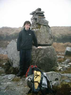
Ascend the lane on R & continue to a sharp bend L. Leaving lane here,go straight through a gate & follow the coach road till it becomes unwalkable. When you have passed the forest on your L & crossed a fence,veer L towards the ridge leading to an obvious cliff locally called the Scalp. Your exact route will depend on the wetness of the terrain. It is an easy ascent from the ridge & the highest point 494 m some metres W of the cliff is marked by a cairn.

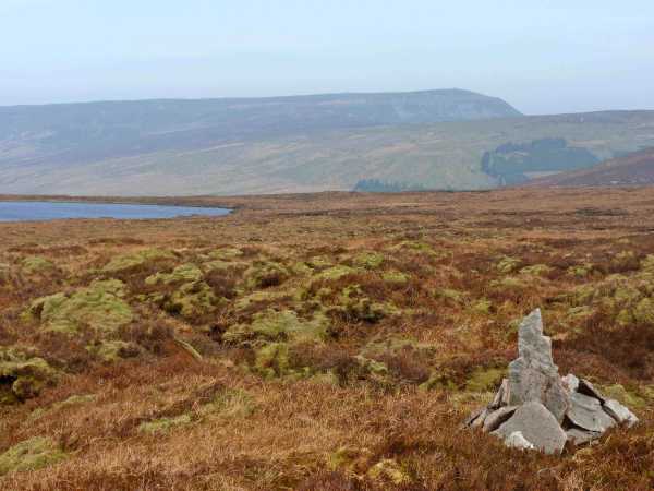
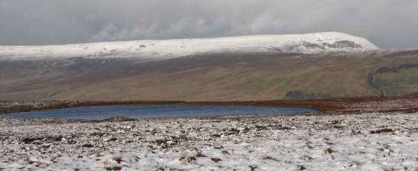
Derrynananta Lough,your next goal,can be seen from here to the SW. Following a bearing 230,crossing a barbless fence,skirting 2 little tarns on R & walking over wet & broken ground,you reach the lough some 30 minutes later. Continue due S to reach the barely distinguishable highest point of Benbrack ,502 m, over more broken boggy terrain. There are good views of lowland Cavan E & the hills of Cavan,Leitrim &Sligo W. Further S you come to the edge of the plateau & descend fairly steeply. Now aim for L of forest F (H106 208). Keep this forest on your R till you reach its other end. There join the rushy track entering wood from SE which leads you to a country road. Take the first L turn(past a burnt out house) & follow road through forest to a T. Turn L & walk to your car just over a mile away. Time:4+ hours & fairly strenuous because terrain. Linkback: mountainviews.ie/summit/450/comment/310/
Read Less
Read More

Keep out ?
by marymac 28 Apr 2013
Thanks to Absalon for the guide to Benbrack. The only damper on an otherwise lovely walk was that when we got back to the 5 cars carefully parked on the side of the road, each one had a handwritten KEEP OUT notice on the windscreen. I don't like thinking we upset a local in any way but am at a loss as to what we did wrong. The few cars that passed us on the return all had a cheery wave and one farmer I met while doing the recce last week said we were more than welcome on his lands at Benbrack. I hope this doesn't prevent future access to what turned out to be a great day out. Linkback: mountainviews.ie/summit/450/comment/14977/
Read Less
Read More

            MountainViews.ie picture about Benbrack (<em>An Bhinn Bhreac</em>)
Picture: The view over Lough Derrynananta to Culcaigh, from the summit of Benbrack
csd on Benbrack
by csd 19 Nov 2006
I approached Benbrack from the southwest, on the road you that takes you past Ben Croy. Parking the car at G (H06742 20440) near the radio transmission masts, you can follow the rough track which will take you closer to the summit. From then it's a slog over the heather, through the bogs, to the track shown on sheet 26 skirting the forest. This track is in the process of being dug up by a JCB, so isn't really much use. Benbrack has a flat summit, riven by peat hags, so it's difficult to find the highest point. Great views from the summit, especially in the snow. Linkback: mountainviews.ie/summit/450/comment/2546/
Read Less
Read More

            MountainViews.ie picture about Benbrack (<em>An Bhinn Bhreac</em>)
Jaak on Benbrack
by Jaak 10 Apr 2007
Nice pleasant climb, although the weather was very poor on the day we bagged it. Started at H (H12386 20061), which is a gate to farmland adjacent to a forest entrance - plenty of parking space here. Enter the farmland and keep to the left hand side of the fields, close to the forest. At the end of the forest the landscape changes to open bogland, with the cliffs of Benbrack clearly visible ahead. The easiest route over the cliffs is to head for an obvious gap about half ways across them - Mag bearing 316 from the end of the forest, although more energetic climbers may opt for the shorter more direct route up the cliffs, which are not dangerously steep, but are a bit of a slog. If you opt to go via the gap in the cliffs, it is a short and relatively easy climb to reach the rim of the mountain, from where it is a short walk to the summit. Although other contributers have described the summit of Benbrack as unmarked, we came across two distinct cairns. The main one, a large stone assembly, close to a circular stone arrangement, is located at I (H102 218), while another smaller cairn exists about 200 metres from this. The smaller one seems to be on higher ground than the large one, although it was quite difficult to judge as visibility was poor at the time and it was not possible to view both at the same time. Linkback: mountainviews.ie/summit/450/comment/2663/
Read Less
Read More
EDIT Point of Interest
text
Videos

Recent Contributions
x
Conditions and Info
Use of MountainViews is governed by conditions and a privacy policy.
Read general information about the site.
Opinions in material here are not necessarily endorsed by MountainViews.
Hillwalking is a risk sport. Information in comments, walks, shared GPS tracks or about starting places may not be accurate for example as regards safety or access permission. You are responsible for your safety and your permission to walk.
See the credits and list definitions.

OSi logo
OSNI/LPS logo
Open Street Map
(Various variations used.)
British summit data courtesy:
Database of British & Irish Hills