Cookies.
This website uses cookies, which are small text files that the website puts on your device to facilitate operation. Cookies help us provide a better service to you. They are used to track general user traffic information and to help the website function properly.
Features
Nearby features appear when you click the map.
Declutter tracks on map.
Place Search
Video
X
Pub: by
Dunkerron Mountains Area , NE: Knocknabreeda Ridge Subarea
Feature count in area: 65, all in Kerry, OSI/LPS Maps: 78, 83, 84, 85, EW-KNP, EW-R
Highest Place: Stumpa Dúloigh 784m

Starting Places (66) in area Dunkerron Mountains:
Ballaghasheen Coilte, Ballaghasheen Pass Viewpoint, Ballaghbeama Gap, Bohacullia, Bridia Valley End, Cahersavane Road, Cahersavane Schoolhouse, Cloon Lough NE, Cloon Lough SE, Coad Cemetery, Coad Road End, Com an Chiste, Coomaclarig Bridge, Coomnahorna River, Coomyanna Bridge, Dereenavurrig, Derreendarragh Church, Derrynane Quay, Dunkerron Mid, Eagles Lough Access Trailhead, Esknaloughoge Forest Trailhead, Fermoyle Farm, Foot Stick Ford Road, Gap of Dunloe Head of, Glashaknockbrassel Stream, Glasheenoultagh Stream, Gortaclohane Lane End, Gortaclohane Lane NE Branch, Gortagowan Wood, Gowlane School Ruin, Gowlanes Wood, Graces Landing, Inchimore West, Isknagahinney Lough E, Kenmare Bridge, Knockanamadane, Knockanaskill N, Knocknasullig, Knocknsallagh Bridge, Laghtacallow, Lissatinnig Bridge Boreen, Looscaunagh Lough W, Lough Barfinnihy CP, Lough Brin S, Lough Coomeen SE, Lough Dromtine NE, Lough Dromtine SE, Lough Fada N, Lough Iskanamacteery N, Lough Iskanamacteery NW, Lough Reagh N, Maghanlawaun Bridia Valley, Molls Gap, Ochtiabh Road, Poulacapple, River Owroe Source, River Sneem Fermoyle Loop, Rossacoosane Mid, Sahaleen Bridge, Scarriff Island, Shamrock Farmhouse B&B, Sneem, Tooreenboy Lough, Tooreennafersha Mid, Tooreennafersha South, Waterville Promenade

Summits & other features in area Dunkerron Mountains:
Knocknagantee Near West Top 628m
Cen: An Bheann Mhór: An Bheann Mhór 674.7m, An Bhinn Láir 514m, Coomcallee 648.9m, Beann na Stiocairí 673.1m, Coomnahorna 590m, Glanbeg 485.8m, Slievenashaska 578m, Slievenashaska South Top 565.4m
Cen: Knocknagantee: Knockmoyle 682.1m, Finnararagh 667m, Cnoc Breasail 591m, Knocknagantee 674.3m, Knocknagantee West Top 553m, Coomnacronia 636m, Coomura Mountain 666m
Cen: Mullaghanattin: An Cnoc Riabhach 534m, Beann 752m, Beann Far SW Top 636.2m, Beann NE Top 692m, Beann South Top 639m, Beann SW Top 657m, Sallagh 570m, Mullaghanattin 773m, Mullaghanattin East Top 594m, Sallagh South-West Top 543m
E: Kenmare: Gortamullin 205m, Knockanaskill 356m, Letter South 362m
N: Knocknacusha: Knocknacusha 547m
NE: Knocknabreeda Ridge: Crossderry 489m, Knocknabreeda 569m, Mothaillín 506m
NE: Knocknagapple: Bascadh 595m, Bascadh West Top 569m, Boughil 631m, Cnoc na gCapall 639m, Knocklomena 641m
NE: Stumpa Dúloigh: Broaghnabinnia 745m, Knockaunanattin 569m, Knockaunanattin West Top 466.1m, Stumpa Dúloigh 784m, Stumpa Dúloigh SE Top 780m, Stumpa Dúloigh SW Top 663m
SW: Caherdaniel: Farraniaragh Mountain 468m, Eagle Hill 155m, Reenearagh 162m, Beenarourke 304m, Knocknasullig 117m, Cahernageeha Mountain 498.7m
SW: Coad ( Castle Cove ): Beenrour 418m, Eagles Hill 549m, Mullaghbeg 509m
SW: Coomduff: Coomduff 244m
SW: Deenish: Deenish Island (2) 144m
SW: Esknaloughoge: Esknaloughoge 416m, Esknaloughoge North Top 420m
SW: Scarriff: Scarriff Island 252m
SW: Sneem: An Bheann Mhór 309.3m, Dereenavurrig Hill 261m, Knockanamadane 270m, Knocknafreaghane 316.5m, Knocknagullion 413m
SW: Staigue: Staigue Top 459m, Staigue NE Top 435m

Note: this list of places may include island features such as summits, but not islands as such.
Rating graphic.
Mothaillín, 506m Mountain
Place Rating ..
(Ir. Mothaillín [OSI - 1:25,000], 'little tufted hill'), Kerry County in Munster province, in Arderin Lists, Mothaillín is the 553rd highest place in Ireland. Mothaillín is the second most northerly summit in the Dunkerron Mountains area.
Grid Reference V85246 80506, OS 1:50k mapsheet 78
Place visited by: 48 members, recently by: farmerjoe1, garrettd, maoris, peter1, millsd1, liz50, Geo, Ulsterpooka, chelman7, annem, muddyboots, daitho9, Fergalh, Grumbler, FrankMc1964
I visited this place: NO (You need to be a logged-in member for this.)
Longitude: -9.670341, Latitude: 51.965309, Easting: 85246, Northing: 80506, Prominence: 92m,  Isolation: 1.7km
ITM: 485220 580566
Bedrock type: Green sandstone & siltstone, (St. Finans Sandstone Formation)

  Short or GPS IDs, 6 char: Mthlín, 10 char: Mothaillín

Linkback: https://mountainviews.ie/summit/442/
Gallery for Mothaillín and surrounds
Summary for Mothaillín : Untracked hard ascents for superb views.
Summary created by Peter Walker, simon3, Colin Murphy 2022-06-23 09:54:13
            MountainViews.ie picture about <em>Mothaillín</em>
Picture: Loch Uachtarach from summit.
There is parking for a couple of cars at A (V849 817). Cross the gate into some woodland and proceed along a short track (paved with concrete slabs) into a grassy field. Head SSE, making sure to avoid drifting towards the almost impassable rhododendron bushes to the right. As you ascend the terrain becomes a mixture of long grass and boulders. The slope is steep and some scrambling and zig-zagging is required. Slope eases at around 300m or point B (V855 815), where you should veer SSW. The final 100m ascent is also steep and requires further navigation around rocky outcrops, although all quite doable.

Alternatively from the south start from the T junction at Knocknsallagh Bridge (V839 786) Walk NW of this beside Cummeralooderry stream until you gain the flattish ground where the stream turns left (West) at around say C (V836 794). Then head for the summit. Don't go up or down beside the lower parts of the Glasheengarriff stream because the way is covered in high rushes, with water and rock in the cracks.

The summit is quite defined, marked by a small grassy mound rising above the rocks and topped by a small pile of stones. 1.5 hours to summit by either route. Allow an hour for descent, which is tricky given the many rocky obstacles. Spectacular views, particularly to the east and north.

PLEASE NOTE: There is an ongoing (as of June 2022) access issue to these hills from the Black Valley side. Please approach from the south.
Linkback: mountainviews.ie/summit/442/comment/5201/
Member Comments for Mothaillín

            MountainViews.ie picture about <em>Mothaillín</em>
Picture: Tip Toe through the Rhododendrons
Carnivorous Plants Abound
by CaptainVertigo 27 Aug 2015
I had decided to go up Mothaillin from the north as part of a longer route. Map study indicated that any approach across Eskwacruttia was likely to be on steep rocky ground, and therefore my plan was to leave the road circa D (V84787 81612) and head east for Derrygarriv somewhere around E (V85885 81547). I would then head straight to the summit across gentle slopes before continuing to Stumpa along the gradually rising ridge.
Unfortunately, all my preparations went out the window as I made my way east along the road south of Cummeenduff Lake in the pre dawn gloom. I could see the the faint silhouette of the mountain and the gobdaw in me couldn't resist taking a "short cut" by leaving the road at about F (V84260 81440) and ascending towards G (V84600 80590). The idea was to get up there, descend into the col and reach Mothaillin. It would be easy, I thought.
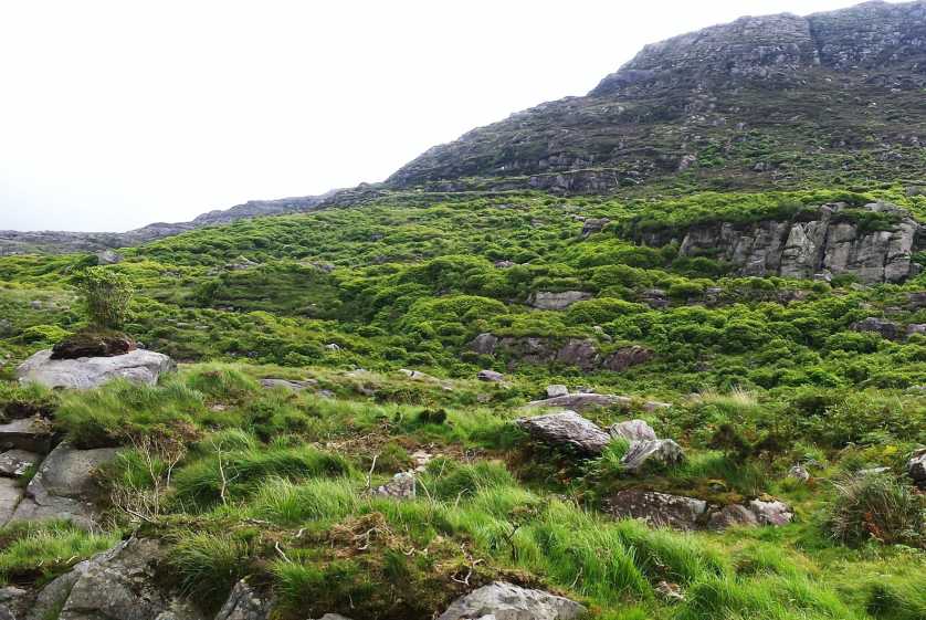
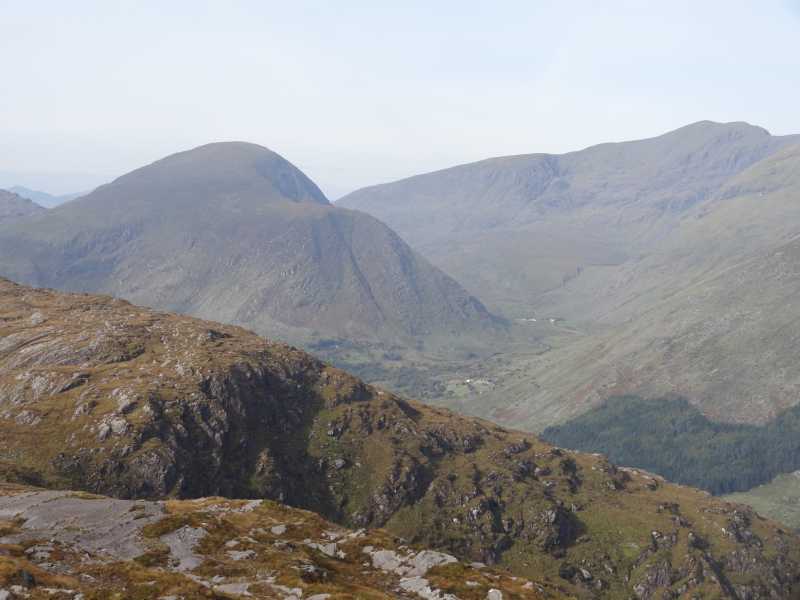
Take a look at the picture I have uploaded. Even in daylight you may feel that the furry green foliage is mere grass surrounding the easily avoided rock buttresses. Wrong! The green stuff is made up of the most dense rhododendron foliage known to man. I fought my way through this jungle with the greatest of difficulty. To make matters worse, I was soaked to the skin by the wet leaves even though the sky was clear. In places I had to crawl on my hands and knees. Getting up little rock buttress was a nightmare. The result:by the time I reached the small prominence by the col to Mothaillin, I was exhausted.
I try to organise routes that permit a gentle start to a day's walking. This allows the body to adjust to the exercise, and develop rythym. I cannot emphasise enough how debilitating my crazy ascent proved to be. It meant that I was forced to abandon part of my planned subsequent route for the day several hours later. It was a high price to pay for my impatience to begin the ascent of Mothaillin.
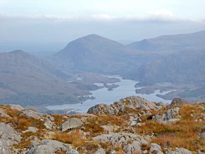
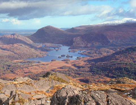
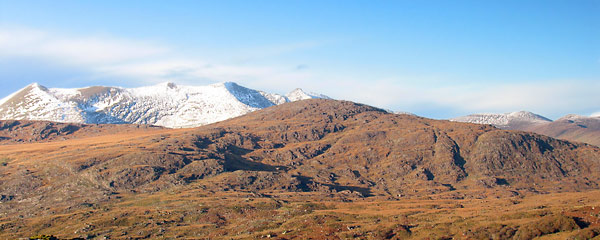
Mothaillin is surrounded by such giants that no one pays much heed to it. As I write in August 2015 only 19 MV members have logged the peak. It's hard to believe. Just look at simon3's photos. The views are of the highest order. It's a mountain that's well worth doing, but please let me know if my original plan would have worked. Linkback: mountainviews.ie/summit/442/comment/18271/
Read Less
Read More

            MountainViews.ie picture about <em>Mothaillín</em>
simon3 on Mothaillín
by simon3 24 Nov 2006
One way of reaching the summit is to start from the T junction at Knocknsallagh Bridge (V839 786). Walk NW of this beside Cummeralooderry Stream until you gain the flattish ground where the stream turns left (West) at around say H (V836 794). Then head for the summit. Don't go up or down beside the lower parts of the Glasheengarriff stream. It's covered in high rushes, with water and rock in the cracks.
This summit is the eastern end of the Dunkerrons, that great ridge of high ground that finally ends near Waterville. The summit and the ridge to it from Knocknabreeda are boggy and flattish underfoot, however the position of the summit gives great views from an unusual angle. Take a look at the Upper Killarney Lake. The shadowed summit just beyond it is Torc Mountain while the snow-covered summit top right is Mangerton. Linkback: mountainviews.ie/summit/442/comment/2554/
Read Less
Read More

            MountainViews.ie picture about <em>Mothaillín</em>
simon3 on Mothaillín
by simon3 24 Nov 2006
The ridge from Mothaillín to Knocknabreeda and beyond runs parallel with Boughil and Knocklomena to the south and the ridge of the Reeks to the North. Magnificent views! Sense of walking amongst the mountains.

The photo has Cnoc an Chuillinn (958m) right of centre on the skyline with Brassel Mountain beneath it. We could see the curious pouncing cloud above Cnoc an Chuillinn as it stretched out from Carrauntoohil, left of centre. A lenticular cloud. Linkback: mountainviews.ie/summit/442/comment/2555/
Read Less
Read More

            MountainViews.ie picture about <em>Mothaillín</em>
Picture: Mothaillín in the winter sun.
simon3 on Mothaillín
by simon3 22 Nov 2006
Low November sun shows the summit, taken from the south.

The road from Killarney to Kenmare goes past the three main ridges of the Iveragh peninsula, from north to south: the Reeks, the Dunkerrons and the Mangertons. This picture is taken from Moll's Gap, a pass over the Mangertons and shows Mothaillín the east end of the Dunkerrons, in front of the snow-covered Reeks. Linkback: mountainviews.ie/summit/442/comment/2553/
Read Less
Read More

            MountainViews.ie picture about <em>Mothaillín</em>
Picture: Broghnabinnia and Caher from Mothillín summit.
Fabulous views to the west from the summit.
by hivisibility 21 Oct 2016
Fine view towards Broghnabinnia and Caher from Mothillín summit. Linkback: mountainviews.ie/summit/442/comment/18681/
Read Less
Read More
EDIT Point of Interest
text
Videos


Users Online

Guests online: 362
Recent Contributions
x
Conditions and Info
Use of MountainViews is governed by conditions and a privacy policy.
Read general information about the site.
Opinions in material here are not necessarily endorsed by MountainViews.
Hillwalking is a risk sport. Information in comments, walks, shared GPS tracks or about starting places may not be accurate for example as regards safety or access permission. You are responsible for your safety and your permission to walk.
See the credits and list definitions.

OSi logo
OSNI/LPS logo
Open Street Map
(Various variations used.)
British summit data courtesy:
Database of British & Irish Hills