Members and Supporters, the MountainViews Committee requests your help to meet the costs of the website and of other activities such as insured events or publications.
Feature count in area: 16, all in Kerry,
OSI/LPS Maps: 71, EW-DC, EW-DE
Highest Place: Baurtregaum 849.7m
Starting Places (15) in area Slieve Mish: Caherconree Scenic Route, Derrymore West Trail, Doonore South, Emlagh Cross, Emlagh Wood, Feighatidura Cove, Glanaskagheen Wood, Greenlawn Cross, Laharn Viewpoint, Lougher, Maum Cross, Maumnahaltora Cross, R561 Lissaroe, Tonavane Cross, Tonavane Walk Kerry Camino
Summits & other features in area Slieve Mish: Cen: Baurtregaum: Baurtregaum 849.7m, Baurtregaum Far NE Top 601.2m, Baurtregaum NE Top 818.5m, Baurtregaum NW Top 723m, Caherconree 835m, Castle Hill 600m, Gearhane 792m E: Barnanageehy: Barnanageehy 561m W: Aughils: Beenduff 515m, Caherbla 585.2m, Emlagh 483m, Knockbrack 459m, Knockmore 565m, Lack Mountain 465m, Moanlaur 566m W: Camp: Corrin 332m
Note: this list of places may include island features such as summits, but not
islands as such.
Beenduff, 515mMountain An Bhinn Dubh A name in Irish,
Place Rating ..
(Ir. An Bhinn Dubh [OSI], 'the black peak'), Splinc, Kerry County in Munster province, in Arderin Lists, Beenduff is the 521st highest place in Ireland. Beenduff is the second most southerly summit and also the second most westerly in the Slieve Mish area.
Grid Reference Q67697 03658,
OS 1:50k mapsheet 71 Place visited by: 75members, recently by: maoris, Tuigamala, Kaszmirek78, garrettd, a3642278, johncusack, Taisce, chelman7, Moses, eiremoss34, maryblewitt, Marykerry, John.geary, eoghancarton, mh400nt
I visited this place: NO (You need to be a logged-in member for this.)
Short or GPS IDs, 6 char: Benduf, 10 char: Beenduff Linkback: https://mountainviews.ie/summit/422/
Gallery for Beenduff (An Bhinn Dubh) and surrounds
Summary
for Beenduff (An Bhinn Dubh):
View Sea and Sky
Summary created by CaptainVertigo
2014-08-23 22:51:06
Beenduff (515m) is one of a number of prominences on a circa 5k ridge of high ground, with relatively minor undulations, running roughly NE/SW from Knockbrack to Emlagh. Most walkers will park near A (Q71563 05353) and traverse Knockbrack, Moanlaur, Knockmore and Beenduff as part of an "out and back" route. This takes advantage of a start height of over 260m in a gap in the Slieve Mish on a minor road from Camp to Aughlis. The prize offered to those summiting Beenduff is superb views of Cromane and Inch strands, Castlemaine Harbour, with mountainous Iveragh in the backgound. An alternative (shorter) route is from Glanmore. This involves driving along The Dingle Way just north of Inch, and following it for about 2k over a rough forest road as the "Way" turns NE. Park either just inside the north eastern edge of the forest (plenty of spaces available), or, if your car is expendable, you can emerge onto the mountain and pull in at B (Q66273 04406) or C (Q66679 04658). (Be warned the road is really only for walkers and tractors once you leave the forest!). The ascent is typical enough. An easy gradient at first over wet grasses, getting stiffer and stiffer as you reach the ridge. The sudden emergence of views of Iveragh and Inch as the summit is gained makes the climb especially rewarding.
Beenduff will probably be reached as part of a traverse or round trip along the Moanlaur, Knockmore ridge. The summit is heather covered with a substantial cairn and few obvious tracks. As with Moanlaur there are great views from this relatively low summit.
The photo shows Emlagh 483m the continuation of the ridge SW with Inch Strand to the left. To the extreme top left is the tip of Rossbeigh strand. Linkback: mountainviews.ie/summit/422/comment/2127/
Read Less
Read More
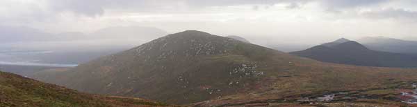
Picture: Beenduff.
simon3 on Beenduff
by simon3
18 Jan 2006
Beenduff, central, takes its place in some great Kerry scenery. To the left on the skyline is Kells/ Knocknadobar. To the right the continuation of the Knockbrack to Beenduff ridge past Emlagh. It's classic Kerry, with mountains seen over sea, with ridges repeating their shape into the distance. Would someone go back there on a day with more direct sunlight? Linkback: mountainviews.ie/summit/422/comment/2148/
Read Less
Read More
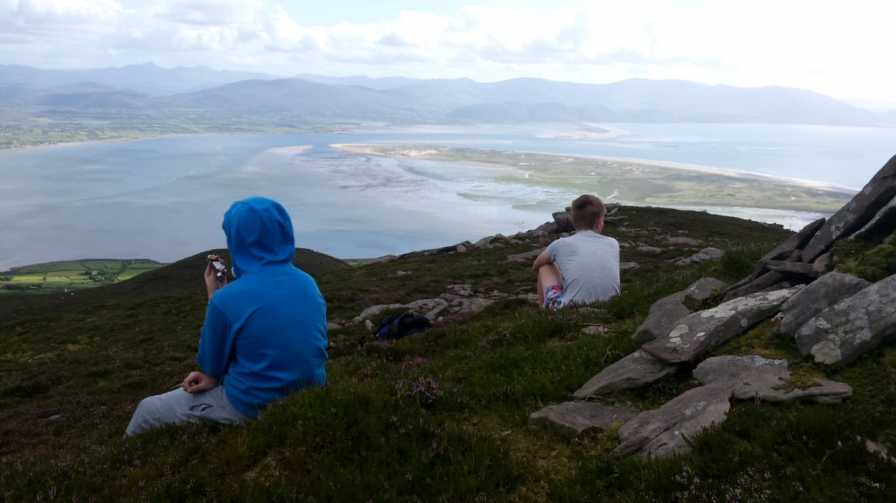
Picture: The Lads Study the Views South
The Glanmore Approach
by CaptainVertigo
23 Aug 2014
My younger boys, John 16 and Peter 13.75, joined me on a short but rewarding hike up Beenmore from Glanmore during our holidays in Kerry in August 2014. Reading the rather stringent rules for Short Summaries made me realise that one can't mention names, Tracks etc and my intended photo would not be acceptable as it shows the view FROM the summit rather than OF the summit. So be it! Well I thought it was a lovely little mountain (missed on a previous hurried outing to Moanlaur) and I especially enjoyed spending a few minutes on the summit, munching a communal snack and taking in the magnificence of Inch and Iveragh in the company of my super fit boys, both of whom seemed to feel that special sense of achievement that comes from the mountaintop moment. As they ran back down ahead of me, I paused to reflect on how memorable these occasions are, mentioned now and then as part of family folklore, and much treasured when the teenagers become adults, and make their own ascents. See Tracks Onzy 2233 and simon3 2007 for the longer traverse from Knockbrack, and my Track 2635 for the route from Glanmore. Linkback: mountainviews.ie/summit/422/comment/17634/
Read Less
Read More
three5four0 on Beenduff
by three5four0
23 Sep 2009
Reached Beenduff from Knockmore, crossing a wide col with peat hags on the way. There is now a faint path running along the ridge, which continues to Emlagh. Good views abound in all directions. See Emlagh for the continuation of the traverse of these hills. Linkback: mountainviews.ie/summit/422/comment/4127/
Read Less
Read More
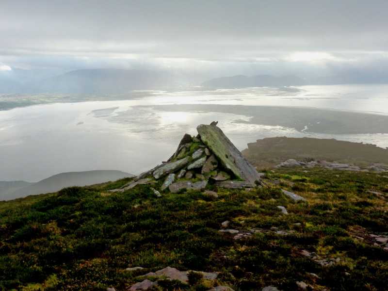
Picture: Sweetness and light
Light at the end of the slog
by Colin Murphy
27 Nov 2014
Beenduff summit is quite a small distinct area, but strangely, the small cairn there was not placed on the highest point, but about fifteen metres south. The highest point is marked by a flat stone, which seems to have been placed there by human hand rather than that of nature. There are great views over Dingle Bay, which looks spectacular when the light is right, as I was lucky enough to experience. Linkback: mountainviews.ie/summit/422/comment/17751/
Use of MountainViews is governed by conditions and a privacy policy.
Read general information about the site. Opinions in material here are not necessarily endorsed by MountainViews.
Hillwalking is a risk sport. Information in comments, walks, shared GPS tracks or about starting places may
not be accurate for example as regards safety or access permission. You are responsible for your safety and your permission to walk.
See the credits and list definitions.


 Our Facebook page.