Members and Supporters, the MountainViews Committee requests your help to meet the costs of the website and of other activities such as insured events or publications.
Feature count in area: 14, by county: Fermanagh: 4, Cavan: 8, Leitrim: 3, of which 1 is in both Cavan and Fermanagh,
OSI/LPS Maps: 26, 27, 27A
Highest Place: Cuilcagh 666m
Starting Places (15) in area Breifne: Aghnacollia Lane, Bellavally Gap, Bencroy, Corneen Wind Farm, Corrawully Lane, Cuilcagh Boardwalk Trail, Dowra, Dowra Sweat House Lane, Glangevlin Cross, Gortalughany Viewpoint, Mullaghgarve Waterfall, Rock Road, Spa Well, Tulliniska Transmitters, Tully Lough
Summits & other features in area Breifne: N: Cuilcagh Mountains: Benaughlin 370m, Benbeg 539m, Cuilcagh 666m, Mullaleam 424m NE: Derrylin: Knockninny Hill 191m, Slieve Rushen 404m SW: Iron Mountains: Bencroy 518m, Knockacullion 562m, Slieve Anierin 585m W: Benbrack: Bartonny Top 411m, Benbrack 502m, Benbrack NE Top 496m, Benbrack West Top 463m, The Playbank 542m
Note: this list of places may include island features such as summits, but not
islands as such.
Bencroy, 518mMountain Gob na bhFiach A name in Irish,
Place Rating ..
(Ir. Gob na bhFiach [PNCL], 'point/beak of the ravens') Gubnaveagh an extra name in English, Leitrim County in Connacht province, in Arderin Lists, Bencroy is the 513th highest place in Ireland.
Grid Reference H04554 19083,
OS 1:50k mapsheet 26 Place visited by: 82members, recently by: abeach, Carolineswalsh, Carolyn105, TipsyDempy, MickM45, conormcbandon, abcd, Hyperstorm, Hillwalker65, srr45, AlanReid, annem, No1Grumbler, derekfanning, Ulsterpooka
I visited this place: NO (You need to be a logged-in member for this.)
Longitude: -7.931339, Latitude: 54.120921, Easting: 204554, Northing: 319083,
Prominence: 83m, Isolation: 2km ITM: 604488 819099 Bedrock type: Sandstone, sandy shale & shale, (Bencroy Sandstone Member) Notes on name: Also known as Gubnaveagh, which is also the name of a townland in the parish of Oughteragh.
Short or GPS IDs, 6 char: Bncry, 10 char: Bencroy Linkback: https://mountainviews.ie/summit/416/
Gallery for Bencroy (Gob na bhFiach) and surrounds
I approached Bencroy from the SW side of Benbrack, some 3 miles to the NE, following a waymarked trail which heads over point 415 m (A (H078 214)), passes a series of little loughs and drops down to a quiet high road at B (H067 205). From here there is a good perspective of the hill, with its gently sloping and heavily forested W slopes and the steep drops to the E. Follow the road towards the 4 sizeable transmitter stations nestling among the hills with good lines of sight E to W for thier signals. Alot of the moorland around here is posted as being part of an experimental grouse project - there are signs of release pens but i did not happen to see any grouse. At the last base station turn onto the hillside and follow the forest edge for 15 minutes to reach the summit area of Bencroy. There is a small quarry high on the S side and a track drops down from here to the road and a carpark - a good access point to this and the following two hills of Knockacullion and Slieve Anierin, the views of which from atop Bencroy are quite impressive. Contour around the hillside below a series of rocky bluffs and then drop down to the col with Knockacullion. Linkback: mountainviews.ie/summit/416/comment/2369/
Read Less
Read More
Picture: Bencroy viewed from saddle below Knockacullion cliffs
eflanaga on Bencroy
by eflanaga
6 Jun 2006
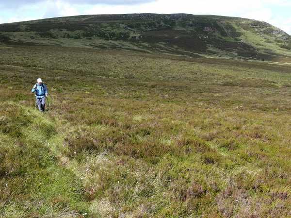
(Climbed 06.02.19) The third and final peak (See Aneirin & Knockacullion for early stages of walk) and only a short distance north-east of Knockacullion. Once again the long grass, gorse and marshy ground make walking that bit more difficult. However, rather than making a beeline straight for the summit and dropping to around 400m, I decided to arc around to the left maintaining a height of about 450m and heading for the obvious light green strip on Bencroy’s southern slope which curves up towards the summit. From a distance it looks like a path. In reality it is slightly rush strewn marshy ground. Nevertheless, it didn’t prove particularly difficult to negotiate. As I neared the final ascent of the mountain I noticed a large flat boulder which appeared a good spot to take lunch. I reckoned that the summit would be as bereft of rocks as Knockabell was so decided to have lunch here, but not until I had made Bencroy’s summit. I divested myself of my pack and climbed the remaining 30 metres or so to the summit unencumbered, returning to the rock to take a leisurely lunch in the warm afternoon sunshine. For the return journey, rather than retracing my steps back to the base of Knockacullion maintaining higher ground I decided to go as the crow flies directly to its eastern cliff edge (C (H036 176)). This meant dropping to a height of about 400 metres to the valley floor. It was rather tough going in the boggy ground and thick gorse before climbing up again to the saddle below the cliff. I hugged the cliff until Lough Nabellbeg came into view and then made for the left side of the Lough, passing the remains of what was perhaps a shepherd's shelter. I eventually found a sheep-track across the raised ground on the Lough's left bank (D (H034 170)). I noticed a discarded beer and gas keg embedded in the ice which persisted on the Lough’s southern end. I wouldn’t presume to speculate as to how, or why, they got to be there. The sheep-path took me to within site of the plantation at Gortnawaun, which I had edged earlier in the morning to climb ridge to the cliff-tops (see Slieve Aneirin). From here I was able to line up the remainder of the walk with a telegraph pole which I knew to be just to the west of the track used for the start of the climb to Slieve Aneirin. A couple of streams and some marshy ground later I reached the track and plodded down it back to the car. The only living creature encountered throughout the entire day - a badger which ran for cover about ten metres in front of me as I descended Bencroy. Overall, a pleasant enough walk after a freezing and disappointing mist-shrouded morning. Would I be in a hurry to do it again? Probably not, but if you appreciate solitude, like to get ‘far from the maddening crowd’ and don’t mind the trudging I would recommend it. Linkback: mountainviews.ie/summit/416/comment/2194/
Read Less
Read More
Picture: Down fron Bencroy along the moorland below the Slieve Anierin Knockacullion ridge
Harry Goodman visits
by Harry Goodman
1 Jun 2022
I climbed Bencroy on 19 June 2008 as part of a circular walk over Slieve Anierin and Knockacullion. Although I walked to the summit at as shown on the Mountain Views list, I noted that this reference did not correspond with the high point shown on the OS I Sheet 26 at E (H049 191) (513m) some 400m further east. There is no point shown on the map at 518m. The top is quite expansive and featureless with a few bumps any of which at a glance could be high points.Has anyone any comments on the difference in the MR and height between Mountain Views and OSI. The OSI high point is 513m. There is no point on the map showing 518m. If in doubt do both. I also used the approach up the light green strip on Bencroy's southern slope described by eflanaga in climb dated 06. 02. 19. The walk back was along the moorland below the Slieve Anierin , Knockacullion, Bencroy ridge to the start point at F (H03200 14700). Linkback: mountainviews.ie/summit/416/comment/3193/
Read Less
Read More
walker_hollick on Bencroy
by walker_hollick
30 Jan 2005
From Drumshanbo take unclassified road to Aghacashel. After passing Aghacashel PO and going over a bridge take a left turn (signposted Ballinagleragh). Continue on for a few miles,
eventually passing through a forest and onto open moorland. Shortly after park at a layby on the right hand side with a waymarker and signposts for Slieve Anierin Way (GR G (H188 053)). Take a track on the left of the road through what appear to be mine workings. When the track reaches
a rather indeterminate ending you are a short distance from the unmarked summit. Linkback: mountainviews.ie/summit/416/comment/1451/
Read Less
Read More
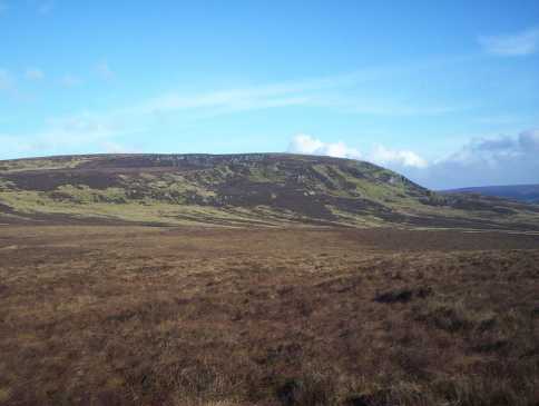
Picture: Cuilcagh in the distance
Three summits on the top
by Wilderness
27 Mar 2018
I climbed this coming from Slieve Anierin . I started in the tiny Aghacashel village where there is a small layby about 50 meters up from the shop ; there is enough space for 3-4 cars. If you don't fancy this option you can start your walk on the country road on the east side of Bencroy; there's a small car park with picnic tables there: H (H054 189). At the top there is three lumps ; it was difficult to tell which one was the true summit but I concluded it was the most westerly facing of the three. Linkback: mountainviews.ie/summit/416/comment/19874/
Use of MountainViews is governed by conditions and a privacy policy.
Read general information about the site. Opinions in material here are not necessarily endorsed by MountainViews.
Hillwalking is a risk sport. Information in comments, walks, shared GPS tracks or about starting places may
not be accurate for example as regards safety or access permission. You are responsible for your safety and your permission to walk.
See the credits and list definitions.


 Our Facebook page.