Donation Request 2024

DONATE
Members and Supporters, the MountainViews Committee requests your help to meet the costs of the website and of other activities such as insured events or publications.
You do not have to be logged in to donate.
Features
Nearby features appear when you click the map.
Declutter tracks on map.
Place Search
Video
X
Pub: by
Slieve Bloom Area , S: Arderin Subarea
Feature count in area: 12, by county: Offaly: 8, Laois: 5, of which 1 is in both Laois and Offaly, OSI/LPS Maps: 54
Highest Place: Arderin 527m

Starting Places (1) in area Slieve Bloom:
General's Road

Summits & other features in area Slieve Bloom:
Cen: Wolftrap Mountain: Carroll's Hill 482m, Castleconor 407m, Stillbrook Hill 514m, Wolftrap Mountain 487m
E: Capard: Baunreaghcong 508.2m, Ridge of Capard 482.1m
S: Arderin: Arderin 527m, Barcam 484m, Farbreague 430m, Garraunbaun 406m
W: Kinnitty: Cumber Hill 316m, Knocknaman 337m

Note: this list of places may include island features such as summits, but not islands as such.
Rating graphic.
Arderin, 527m Mountain Ard Éireann A name in Irish,
Place Rating ..
(Ir. Ard Éireann [logainm.ie], 'the height of Ireland' or 'Eriu’s
height')
County Highpoint of Laois & Offaly and in Laois/ Offaly counties in Leinster province, in County Highpoint, Arderin Lists, Arderin is the highest mountain in the Slieve Bloom area and the 482nd highest in Ireland. Arderin is the highest point in county Laois and also the highest in Offaly.
Grid Reference S23244 98902, OS 1:50k mapsheet 54
Place visited by: 422 members, recently by: rhw, purpleknight, MartMc, GerryAlex, discovering_dann, knightsonhikes, nolo, JordanF1, MarionP, edowling, Tuigamala, claireod5, Buckz, westside, cactustravelfan
I visited this place: NO (You need to be a logged-in member for this.)
Longitude: -7.654389, Latitude: 53.040547, Easting: 223244, Northing: 198902, Prominence: 420m,  Isolation: 1.2km, Has trig pillar
ITM: 623177 698931
Bedrock type: Pale & red sandstone, grit & claystone, (Cadamstown Formation)
Notes on name: "On the last Sunday in July the people of Mountrath, Trumera, and the surrounding districts go up on the Slieve Bloom Mountains, on to the slopes of Ard Erin. They bring with them food, and spend the day on the mountain. There are all kinds of games and trials of strength, and in the evening they kindle big fires, and the young men run races round the fires, and the more daring of them leap over the fires. In this district, this Sunday is called Height Sunday." (Helen Roe in Béaloideas ix, p. 31). See Máire MacNeill, 'The Festival of Lughnasa' (pp. 221-25) for a fuller account of the festive assembly on 'Height Sunday' on Arderin.
  Short or GPS IDs, 6 char: Ardrn, 10 char: Arderin

Linkback: https://mountainviews.ie/summit/399/
Gallery for Arderin (Ard Éireann) and surrounds
Summary for Arderin (Ard Éireann): The height of Ireland
Summary created by jackill 2011-01-19 20:20:18
            MountainViews.ie picture about Arderin (<em>Ard Éireann</em>)
Picture: Looking towards Barcam and Carrolls Hill
Park in the car park at A (S231 996) just on the county bounds, room for 10 cars. Drop down a short grassy slope on from the carparks east side, cross a stream and up a boggy, mud track to the summit. The top is marked by a OS trig point at ground level and a small cairn. The road up from the Mountrath side has a very good surface however the road down the western side is rutted and collapsed in sections.
Linkback: mountainviews.ie/summit/399/comment/5158/
Member Comments for Arderin (Ard Éireann)
Comment create / edit display placeholder

paulocon on Arderin
by paulocon 11 Mar 2009
Tackled Arderin as part of my goal to stand atop the highest point of each county. From the sleepy village of Kinnity, the Glendine Drive takes you up across the twisty Glendine Gap road. Built in the 90's, the road has not aged well as is in a bad state of disrepair in a number of sections. Parked at the carpark below the monument on the border and from there a 15-20 minute walk in drizzle took me to the mist covered summit. For me, Arderin was one of those hills where I found myself asking why I bother as I went ankle deep into yet another pool of boggy mud. The desolate and now rain-soaked summit proved uninspiring and brought back memories of a similar day on the equally desolate Slieve Beagh in Monaghan but the fact that visibility was down to about 100 metres has to be taken into account. All in all, an easy way to bag two county tops in one short walk. Perhaps in better weather, Arderin will prove itself to be something more than an Ugly Sister. Linkback: mountainviews.ie/summit/399/comment/3636/
Read Less
Read More

            MountainViews.ie picture about Arderin (<em>Ard Éireann</em>)
Picture: Three sentries Clamp Hole Waterfall
dhmiriam on Arderin
by dhmiriam 3 Aug 2006
Part one

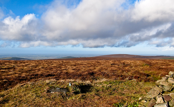
Sliabh Bloom is half of God’s round lap in my own county of Laois, the other half stretching into my neighbours, Co. Offaly. I am inclined to believe, like the poet Patrick Kavanagh that my God is surely feminine as this lap is large, round and accepting as mothers laps should be. One can hop on from many points all almost within half-hours drive or less from Mountrath, Portlaoise and Ballyfin, that is, from the Laois aspect. Mountainviews would probably consider these mountains bumps, at only 440m to Stony Man on top of Ridge of Capard, or at The Cut.
Arderin, (height of Ireland) is a mighty 527m in comparison. I have sadly never completed the entire Slieve Bloom Way, 43 miles in total. Have done as you would eat an elephant, little bits at a time. What you see here is heather glens and ridges, conifer forests, ford rivers and birch woodland. What is particular up here is the extent of the views away from the hills, when very high. I think this is because the midlands have such a flat basin generally that there is no competition to impede the far horizon and but for the limitations of sight when the skies are clear, I feel I could see forever.

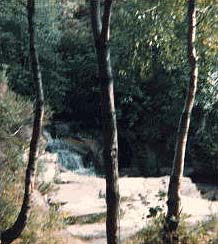
Two falls up here, Clamp Hole Waterfall and White Horse Falls. More Glens than you can shake a stick at, Glendelour gleann deileabha,(Valley of the two forked river) Glendine gleann doimhin (Deep Valley), Glenamoon gleann na móna or Mumhan,(Valley of the bog), Glenbordowin gleann bórd abhainn ( Valley of the River Bank), Glenconra gleann cuan, cónra or con, (Valley of the hollow, coffin or hounds, edges a bit fuzzy on this one), Glenall, gleann aille ( Valley of the cliff), Glenkitt, gleann ceath valley of the showers or mists, Glenafelly, gleann……, open to interpretation this one too, could be valley of treachery, Glenkeen, gleann caoin, pleasant valley, Glenlahan, gleann leathen (The broad valley) and Glenbarrow, gleann beiriú, the boiling valley, to name just a few. If the place needed a blanket name methinks Sliabhnaglen, Mountain of valleys, might be apt.

More in part 2. Linkback: mountainviews.ie/summit/399/comment/2449/
Read Less
Read More

            MountainViews.ie picture about Arderin (<em>Ard Éireann</em>)
Picture: Summit of Arderin
nolan on Arderin
by nolan 28 Jan 2009
I wanted to get this summit out of the way and as the road through the Glendine Gap was covered in ice the last time i tried, this time i decided to track it from the Camross side. On the morning of the 28th January i parked the car at B (S241 967) and made my way to the summit from here. The views behind me towards East were fabulous on the way up and as it was a perfect day the views from the summit were also splendid. It takes about 50 mins to reach the summit from this side but its an enjoyable walk. There's a farm track for about a third of the way but after this the ground becomes very heavy as you're walking across bog. Linkback: mountainviews.ie/summit/399/comment/3550/
Read Less
Read More

            MountainViews.ie picture about Arderin (<em>Ard Éireann</em>)
simon3 on Arderin
by simon3 16 Nov 2002
Quoted in Bladhma (TP Joyces 1995 guide to the Slieve Blooms) J. Baldwin reported in 1819 that "The view from the Heights of Ireland comprises 15 counties, and is perhaps the most extensive and richest in Ireland"
When I visited it with a Slieve Blooms cognoscenti on a wet November day the view was limited to around 20m and included what looks like the remains of an amateur TV re-transmitter.
It was an easy walk from a car park at A (S231 996), across a stream and up a boggy track to the summit. We knew for sure we had reached the top because of an OS marker there, otherwise this would not have been very certain.
Incidentally the easiest way to reach this carpark is from Glendine to the East along a surprisingly twisty road which was only completed in 1994.
The photo shows the summit. Linkback: mountainviews.ie/summit/399/comment/219/
Read Less
Read More

Ireland's Deepest Mud
by MountainBoy 9 Apr 2017
As part of our quest to stand at the top of every Irish county, I and my Dad visited this peak on the 8.4.17. After some searching, we found the road to the Glendine Gap. The journey upwards became an anxious one as we were constantly looking out for the Laois-Offaly border marker we had seen in Kieron Gribbon's essential Ireland's County High Points : A Walking Guide. Halfway up the road, we stopped to admire the beautiful views offered by a gap in the trees and also to express our annoyance at the presence of a burned-out car. When we did reach it, was almost impossible to miss the border marker, with the new addition (possibly) of a plaque commemorating the founder of the Slieve Bloom Mountaineering Club. In the car park behind the marker, we found ourselves inadvertently disturbing the amorous undertakings of a young couple and, not wishing to provoke anything more than disapproving looks from them, we quickly got ourselves in order and set off along the clearly defined (on a good day) track leading to the summit of Arderin (Ard Erin, Ireland's Height). We quickly discovered why Paulocon wondered why he had bothered, as we found ourselves continually sinking into ankle-deep mud. After a highly annoying false summit and 20 minutes of squelching, we reached the top. Something that should be noted by anybody who is doing the CHP challenge is that the high points of Offaly and Laois are actually separate. Offaly's is located, as is widely known, at the toe-level circular plaque. Laois' was, until recently, unmarked. However, a helpful soul has recently erected the smallest trig pillar I have ever seen. After the obligatory photos and focaccia, it was back down to the car park and Sheeran's Village Inn of Coolrain (highly recommended). Accompanying us all the way back home was a sense of hope that Benbaun can be visited on Easter Sunday. Linkback: mountainviews.ie/summit/399/comment/18878/
Read Less
Read More
EDIT Point of Interest
text
Videos
(none available)
Recent Contributions
x
Conditions and Info
Use of MountainViews is governed by conditions and a privacy policy.
Read general information about the site.
Opinions in material here are not necessarily endorsed by MountainViews.
Hillwalking is a risk sport. Information in comments, walks, shared GPS tracks or about starting places may not be accurate for example as regards safety or access permission. You are responsible for your safety and your permission to walk.
See the credits and list definitions.

OSi logo
OSNI/LPS logo
Open Street Map
(Various variations used.)
British summit data courtesy:
Database of British & Irish Hills