This website uses cookies, which are small text files that the website puts on your device to facilitate operation. Cookies help us provide a better service to you. They are used to track general user traffic information and to help the website function properly.
Feature count in area: 62, by county: Cork: 45, Kerry: 24, of which 7 are in both Cork and Kerry,
OSI/LPS Maps: 78, 79, 85, 86, 88, 89
Highest Place: Knockboy 704.8m
Starting Places (47) in area West Cork Mountains: Barley Lake North, Barrboy, Caha Pass, Carranmore, Carrigacappeen, Carriganass Castle, Castle Donovan Car Park, Clearagh House, Coolkellure House, Coomhola Bridge, Corrigatirra, Cousane Gap, Cummer Lough East Road, Derreencollig Wood, Esk Boreen, Fuhiry Wood, Garinish Island Pier, Glasagarav River Bridge, Glasnacummeen Stream, Glengarriff, Glengarriff Nature Reserve CP, Gorteeniher Drimoleague Heritage Walk CP, Gortloughra River Road, Gougane Barra Oratory, Gougane Barra Park CP, Grousemount Wind Farm, Kealkill Village, Knockanuha, Knockbrack South, Lough Atooreen N, Lough Nambrackderg North, Lough Nambrackderg Wood, Lough Nambreacdearg, Mealagh Bridge, Molly Gallivan's Visitor Centre, Nowen Hill West Road, Owvane River Bridge, Pookeen North Top Road, Pooleen Wood Car Park, Priests Leap, Reenroe Bridge, River Roughty, Shandrum Concrete Silo, Sillahertane Stream, Slaheny River Horseshoe, Top of Coom, Turner's Rock Tunnel
Summits & other features in area West Cork Mountains: Cen: Maughanaclea: Maughanaclea Hills East Top 470m, Maughanaclea Hills West Top 452m Cen: Shehy More: Shehy More 545.6m, Shehy More SW Top 446m E: Clearagh: Clearagh Hill 287m E: Currane: Currane Hill 228m N Cen: Douce: Douce Mountain 476m, Doughill Mountain 471m N: Carran: Barnastooka 497m, Bealick 537m, Carran 604m, Carran Far NE Top 561m, Carran Far North Top 506m, Carran NE Top 555m, Carran South Top 567m, Knockantooreen 450m N: Conigar: Conigar 566m, Conigar SW Top 566m, Foilastookeen 540m N: Coomataggart: Carrigalougha 423m, Coomataggart 530m, Coomataggart SW Top 509m, Derrineanig 304m, Lackabaun 472m, Mweelin 487m NE Cen: Carrigarierk: Carrigarierk 343m NW: Barraboy: Barraboy Mountain 460m, Barraboy Mountain Far East Top 456m, Barraboy Mountain SE Top 409m, Derroograne 468m, Turners Rock 420m NW: Knockboy: Caoinkeen 692.8m, Caoinkeen South-East Top 553.5m, Coomhola Mountain 472m, Knockboy 704.8m, Knockboy North Top 651.2m, Knockboy South Top 533.3m, The Priest's Leap 519m NW: Knocknamanagh: Bird Hill 412m, Coomclogherane Top 449m, Gullaba Hill 603m, Knockbrack 440m, Knockbrack South Top 458m, Knocknamanagh 637m, Knocknamanagh NE Top 625m S Cen: Dunmanway Hills: Cashloura 296.8m, Coolsnaghtig 295.8m, Inchanadreen 310m S Cen: Nowen: Milane Hill 354.4m, Mullaghmesha 494.3m, Nowen Hill 535.2m, Nowen Hill Far West Top 405.2m, Nowen Hill SW Top 509m, Pookeen North Top 319m S: Leap Hills: Carrigfadda 311.7m, Killeigh Hill 229m, Knockarudane Hill 169m, Knockscagh 195m S: Skibbereen: Barryroe Hill 156m, Lick Hill 158m W Cen: Knockbreteen: Knockbreteen 239m W: Bantry: Knocknaveagh 282m
Note: this list of places may include island features such as summits, but not
islands as such.
Nowen Hill, 535.2mMountain Cnoc na nAbhann A name in Irish,
Place Rating ..
(Ir. Cnoc na nAbhann [OSI], 'hill of the rivers'), Cork County in Munster province, in Arderin Lists, Nowen Hill is the 459th highest place in Ireland.
Grid Reference W14067 52901,
OS 1:50k mapsheet 85 Place visited by: 83members, recently by: Ansarlodge, Lucy.boland, DeirdreM, a3642278, CusackMargaret, johncusack, jackos, Wilderness, amgall, John.geary, mountainmike, Ulsterpooka, annem, osullivanm, simon3
I visited this place: NO (You need to be a logged-in member for this.)
Short or GPS IDs, 6 char: NwnHl, 10 char: Nowen Hill Linkback: https://mountainviews.ie/summit/384/
Gallery for Nowen Hill (Cnoc na nAbhann) and surrounds
Summary
for Nowen Hill (Cnoc na nAbhann):
Nowen home.
Summary created by jackill
2012-05-24 20:44:09
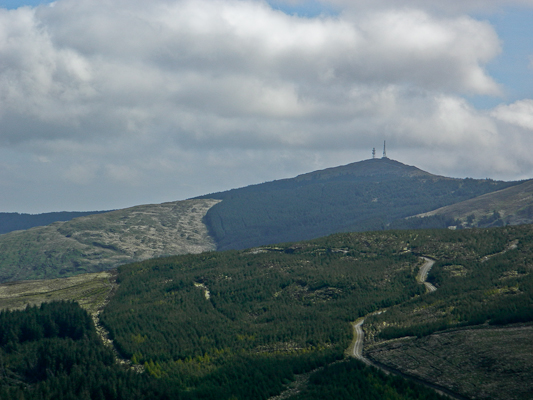
Picture: As seen from Mullaghmesha
Park at the forestry entrance Barrboy (W13673 54386), room for 2-3 cars. Walk uphill on a generally good forest road to the summit. As mentioned by thomas_g there are " you are on a farm signs" a little way along this track but they seem to point both ways , I took them to possibly refer to an access track between them , a distance of less than 100 meters. Also there is a standard Coillte rules of access sign at the start of this track so access should be fine.
the summit is a mess of bulldozed ground, portacabins and aerials.
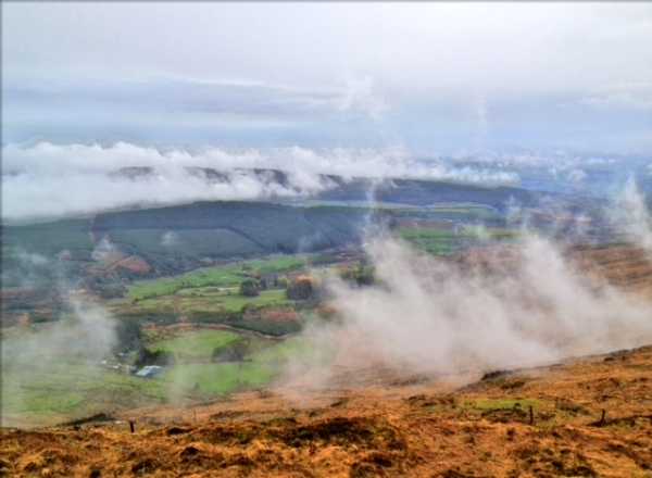
The Mealagh valley sign marks where I parked at Barrboy (W137 544) (room for 6 cars), it's like the valley that time forgot and feels very isolated. There is a forest road all the way to the summit, which starts out level and gets steep at the end. The ascent doesn't offer much in the way of views, but the views to the south must be stunning on a clear day, if you can forget all the masts.
I'm wary about the access, I noticed some of the standard "you are on a farm, no un-authorised entry" signs about 1/3 the way from the car. They appear to point in both directions, so I'm a bit unsure where you can't enter, but there are possible access problems via this route.
I had intended to bag another Arderin by walking the 1.5km to Nowen SW, but the terrain looked truly horrible, tussocky grass with bog between the tussocks, I'll keep that treat for a drier day.
With this route, 5km, you'll up and down in an hour. Linkback: mountainviews.ie/summit/384/comment/6679/
Read Less
Read More
mart on Nowen Hill
by mart
5 May 2004
There is a road leading up to the summit, which is crowned with 3 masts. The views can be very good, down to a lake just below the hill and out towards the coast of West Cork and the chain of the Caha mountains trailing off into the sunset. Linkback: mountainviews.ie/summit/384/comment/959/
Read Less
Read More
TrebleRed on Nowen Hill
by TrebleRed
3 Jan 2006
I have walked up the track a few times now. The views are spectacular if you go on a clear day, the walk only takes about an hour and fifteen minutes allowing for a few minutes on the summit enjoying the views. I would be interested in knowing of any cross country routes to the summit if anyone knows of one. Linkback: mountainviews.ie/summit/384/comment/2113/
Read Less
Read More
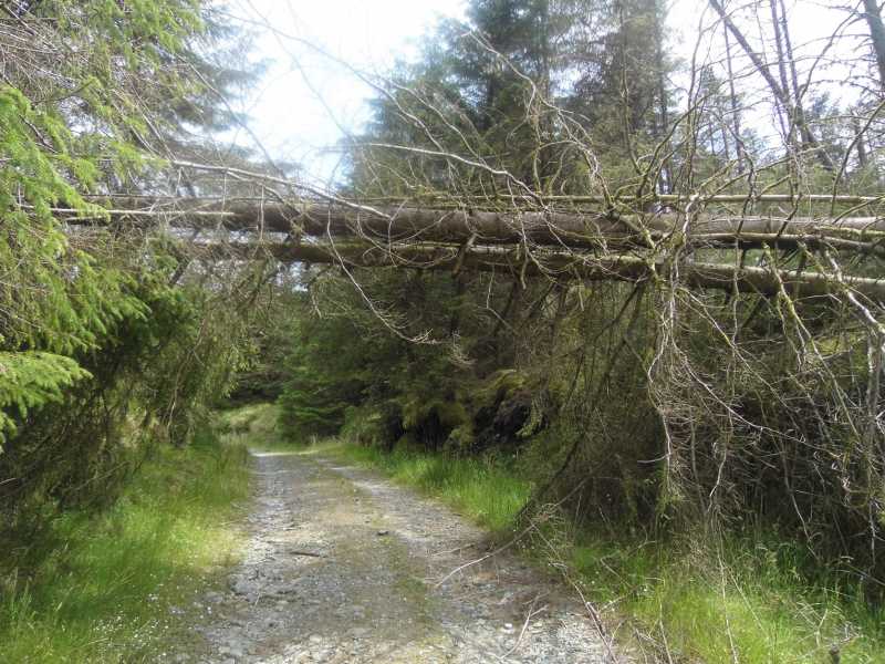
Picture: Under the tree to get to the top.
Straight forward bag.
by TommyV
5 Jul 2019
Straight forward out and back route on a Coilte track to the masts at the top. Make sure to take the track to the left at A (W13586 53096) as this is the one that leads to the summit but if you weren't aware it does look like continuing straight on is the way as the correct track had a felled tree. Linkback: mountainviews.ie/summit/384/comment/20177/
Use of MountainViews is governed by conditions and a privacy policy.
Read general information about the site. Opinions in material here are not necessarily endorsed by MountainViews.
Hillwalking is a risk sport. Information in comments, walks, shared GPS tracks or about starting places may
not be accurate for example as regards safety or access permission. You are responsible for your safety and your permission to walk.
See the credits and list definitions.


 Our Facebook page.