Members and Supporters, the MountainViews Committee requests your help to meet the costs of the website and of other activities such as insured events or publications.
Feature count in area: 28, all in Mayo,
OSI/LPS Maps: 22, 23, 30, 31, CBW, EW-ACC, EW-WNN, EW-WNS
Highest Place: Slieve Carr 721m
Starting Places (24) in area Nephin Begs: Altnabrocky Adirondack Shelter, Bellanaderg Bridge, Brogan Carroll Bothy, Bunnahowna Bridge, Bunnahowna River, Burrishoole Loop, Cloondaff Church, Deel River, Furnace Lough E, Glasheens River, Glendahurk Bridge, Glennamong Bridge, LFeeagh E Treenbeg Cottage, LFeeagh E Treenbeg School Ruin, Lough Avoher Hut, Lough Feeagh, Lough Gall NW Mayo, Loughanawillan Loughs Track, Mulranny Post Office, R312 Boghadoon, R312 Prughlish, Srahduggaun, Tarsaghaunmore River, Wild Nephin Wilderness
Summits & other features in area Nephin Begs: Cen: Glennamong: Bengorm 582m, Bengorm NW Top 468m, Corranabinnia 716m, Corranabinnia SW Top 687m, Glennamong 628m, Glennamong East Top 415m, Tirkslieve 401m Cen: Nephin Beg: Aroher Hill 285m, Lettertrask 279m, Nephin Beg 627m, Nephin Beg South Top 410m E: Birreencorragh: Birreencorragh 698m, Birreencorragh South Top 564m, Birreencorragh West Top 551m, Buckoogh 588m, Bullaunmore 388m, Knockaffertagh 517m, Mount Eagle 427m, Srahmore 186m, Srahrevagh North 282m NW: Slieve Carr: Bunmore 243m, Sheeanmore 282m, Slieve Alp 329m, Slieve Carr 721m, Tawnyanruddia 531m SW: Maunthomas: Claggan Mountain NE Top 501m, Maumthomas NE Top 440m, Maumthomas SW Top 477m
Note: this list of places may include island features such as summits, but not
islands as such.
Birreencorragh West Top, 551mMountain Birín Corrach (mullach thiar) A name in Irish,
Place Rating ..
For origin of name, see Birreencorragh., Top of Leana, Mayo County in Connacht province, in Arderin Lists, Birreencorragh West Top is the 419th highest place in Ireland.
Grid Reference G01457 04987,
OS 1:50k mapsheet 23&31 Place visited by: 99members, recently by: kernowclimber, mcrtchly, poopoobasto, Carolineswalsh, srr45, tonio22, ochils_trekker, Krzysztof_K, NualaB, abcd, Timmy.Mullen, Carolyn105, ryanguinness10, elizauna, nupat
I visited this place: NO (You need to be a logged-in member for this.)
Short or GPS IDs, 6 char: BrncWs, 10 char: BrncrgWstT Linkback: https://mountainviews.ie/summit/357/
Gallery for Birreencorragh West Top (Birín Corrach (mullach thiar)) and surrounds
Summary
for Birreencorragh West Top (Birín Corrach (mullach thiar)):
Detour for a View
Summary created by Onzy
2014-10-07 14:34:25
Picture: pic:gerrym
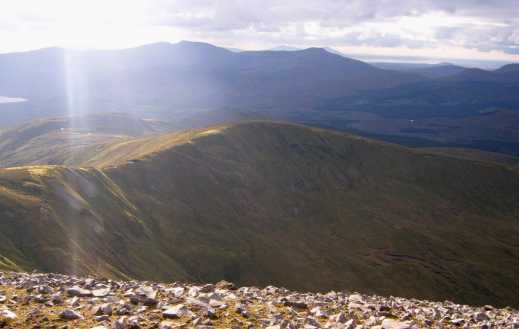
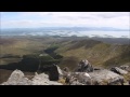
Birreencorragh West Top is an unremarkable peak one km west of the main peak and only a short detour from the main circuit of the Glendorragha Valley. It has spectacular views of the north west face of Birreencoreragh.
It will normally be climbed from the south and in conjunction with the main peak. The best approaches are from the Coillte forest at the mouth of the valley. There are parking places here, at A (G042 027) A and B (G035 024) B, a good way along forest tracks from the road. From the second of these spaces head north up a grassy rise towards sh336, west to Birreencorragh South Top and north to West Top, contouring around Birreencorragh itself.. It should take under 1.5hours to the top.
The obvious option from here is to tackle the main summit and then the ridge curving from north to south east around the valley and reaching Knockaffertagh. From here a descent to the valley floor and a return to the car using forest tracks is possible. Be careful of the descent off Knockaffertagh; it may be better to head east from the summit and contour over gentler ground than to tackle the steep ground directly south.
The NW ridge is only a short detour off the route around the Glenlar - Birreencorragh - Knockaffertagh horse shoe. It took me 10 mins to reach the top but it was definitely worth it to get another perspective on Birreencorragh, with its impressively long and scree covered N ridge sweeping down into the dividing river valley. The NW ridge continues down towards Letterkeen Wood and I suppose could be used as a different access point for the climb - it did look impressive from the valley to the W the next day when I was climbing Buckoogh. The view from here is also captivating - from the big hills of Connemara across a sun dappled Clew Bay to the rugged peaks of the rest of the Nephin Begs and N across the lowlands to the N Mayo coast. Linkback: mountainviews.ie/summit/357/comment/1964/
Read Less
Read More
Picture: View north from Birreencorragh West Top
eflanaga on Birreencorragh West Top
by eflanaga
5 Oct 2007
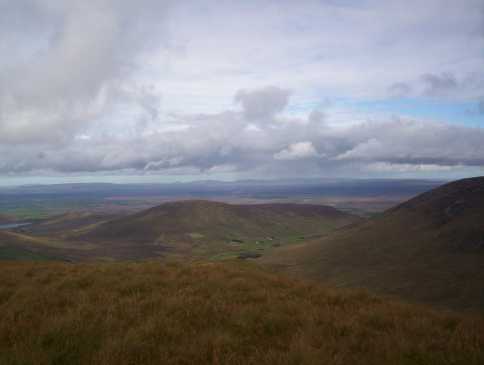
From Birreencorragh South Top (see for first part of Horseshoe walk) it is a relatively easy walk to its sister summit. Dropping down from the South-Top onto Spot Ht 539 IC (G02398 03694) you proceed onwards to the col dividing the main summit from the West Top (now a short distance directly North) and the spur dropping down to Mount Eagle to the west. The West top is (as gerrym suggests) just a short distance away necessitating a short drop to a narrow saddle ID (G01651 04811) and then an equally short climb to a featureless grassy domed top. The views, however, into the main Nephin Beg range to the west/north-west, north towards the Ox Mountains and across a beautiful narrow secluded valley to the main summit are anything but plain. Picture shows view north over Bullaunmore towards the Ox Mountains in the distance, from Bireencorragh West Top. Having taken the mandatory GPS reading and a few photographs I retraced my steps to the narrow saddle with a view to making my way onwards to Birreencorragh's main top. Linkback: mountainviews.ie/summit/357/comment/2855/
Read Less
Read More
csd on Birreencorragh West Top
by csd
18 Oct 2004
A view of Birreencorragh's West Top from the Glenlara - Birreencorragh ridge, showing the long shoulder down from Birreencorragh proper on the right. Linkback: mountainviews.ie/summit/357/comment/1253/
Use of MountainViews is governed by conditions and a privacy policy.
Read general information about the site. Opinions in material here are not necessarily endorsed by MountainViews.
Hillwalking is a risk sport. Information in comments, walks, shared GPS tracks or about starting places may
not be accurate for example as regards safety or access permission. You are responsible for your safety and your permission to walk.
See the credits and list definitions.


 Our Facebook page.