Donation Request 2024

DONATE
Members and Supporters, the MountainViews Committee requests your help to meet the costs of the website and of other activities such as insured events or publications.
You do not have to be logged in to donate.
Features
Nearby features appear when you click the map.
Declutter tracks on map.
Place Search
Video
X
Pub: by
Sperrin Mountains Area , NE Cen: Glenelly North East Subarea
Feature count in area: 64, by county: Derry: 34, Tyrone: 39, of which 9 are in both Derry and Tyrone, OSI/LPS Maps: 12, 13, 6, 7, 8
Highest Place: Sawel 678m

Starting Places (21) in area Sperrin Mountains:
Altinure Road, Banagher Glen Nature Reserve, Barnes Gap Car Park, Crocknakin, Drumnaspar Picnic CP, Glenchiel Road, Glenedra Bridge, Glenelly Road, Parkreagh, Goles Road, Lough Ouske, Moneyneany Village, Moydamlaght Forest, Moydamlaght Road, Mullaghmore, Mullaghbane, Spaltindoagh, Sperrin Hamlet, Sperrin Heritage Centre, Sperrin Heritage Centre W, Sperrin Road, Barnes Top, Sperrin Road, Glashagh Bridge, Sperrin Road, Sperrin

Summits & other features in area Sperrin Mountains:
E: Magherafelt Hills: Slieve Gallion NE Top 493.6m
E: Magherafelt Hills: Slieve Gallion 526.6m
N: Claudy Hills: Crockdooish 321m, Curradrolan Hill 270m, Eglish 277m, Letterlogher 249m, Mullaghmeash Hill 244m, Slieveboy 259m, Straid Hill 303m
NE Cen: Glenelly North East: Barnes Top 456m, Craigagh Hill 460m, Crockbrack 526.1m, Knockanbane Mountain 441m, Meenard Mountain 620m, Meenard Mtn W Top 480m, Mullaghaneany 627m, Mullaghash 480m, Mullaghsallagh 485m, Oughtmore 569m, Spelhoagh 568m
NE: Glenshane North: Benbradagh 465m, Boviel Top 454m, Carn Hill 448m, Carntogher 464m, Moneyoran Hill 414m
NE: Glenshane South: Bohilbreaga 478m, Coolnasillagh Mountain 423m, Corick Mountain 430m, Crockalougha 407m, Mullaghmore 550m, White Mountain 537m
NW Cen: Glenelly North West: Dart Mountain 619m, Dart Mountain North-West Top 525m, Learmount Mountain 489m, Learmount Mountain South Top 492m, Mullaghasturrakeen 581m, Mullaghcarbatagh 517m, Mullaghclogha 635m, Mullaghclogher 572m, Mullaghdoo 568m, Sawel 678m
NW: Maheramason Hills: Clondermot Hill 220m, Gortmonly Hill 218m, Slievekirk 370m
SE Cen: Glenelly South East: Carnanelly 562m, Carnanelly West Top 503.4m, Mullaghbane 467m, Mullaghturk 416m
SE: Cookstown Hills: Cregganconroe 300m, Fir Mountain 362m, Oughtmore 382m
SW Cen: Glenelly South West: Clogherny Top 408m, Craignamaddy 385m, Crocknamoghil 335m, Mullaghbolig 442m, Spaltindoagh 420m
SW: Mullaghcarn: Curraghchosaly Mountain 416m, Mullaghcarn 542m, Mullaghcarn South Top 525m
SW: Newtownstewart Hills: Bessy Bell 420m, Mullaghcroy 242m
W: Strabane: Balix Hill 403m, Knockavoe 296m, Owenreagh Hill 400m

Note: this list of places may include island features such as summits, but not islands as such.
Rating graphic.
Oughtmore, 569m Mountain Ucht Mór A name in Irish,
Place Rating ..
(prob. Ir. Ucht Mór [PDT], 'big mountain-breast'), Derry/ Tyrone County in Ulster province, in Arderin Lists, Oughtmore is the 368th highest place in Ireland.
Grid Reference H70005 97494, OS 1:50k mapsheet 13
Place visited by: 119 members, recently by: Tricia-Mulligan, No1Grumbler, dino, Paddym99, Sperrinwalker, garybuz, Cecil1976, ElaineM76, derekfanning, AlanReid, Claybird007, mdehantschutter, osullivanm, annem, fingalscave
I visited this place: NO (You need to be a logged-in member for this.)
Longitude: -6.911709, Latitude: 54.820392, Easting: 270005, Northing: 397494, Prominence: 104m,  Isolation: 0.9km
ITM: 669940 897486
Bedrock type: Psammite & semipellite, (Glenelly Formation)

  Short or GPS IDs, 6 char: Oghtmr, 10 char: Oughtmore

Linkback: https://mountainviews.ie/summit/330/
Gallery for Oughtmore (Ucht Mór) and surrounds
Summary for Oughtmore (Ucht Mór): Sperrin Colours
Summary created by simon3, march-fixer 2012-10-01 17:34:15
            MountainViews.ie picture about Oughtmore (<em>Ucht Mór</em>)
Picture: Red, blue, green and yellow. Summit from the NW.
Part of the horse-shoe incorporating Mullaghaneany and Craighagh Hill, it is a most unassuming summit. However, The views from here are excellent, with an uninterrupted vista out east over Maghera, Magherafelt and beyond.

Mostly reached as part of an walk up from the B40 road via Mullaghaneany or Craighagh Hill, it may also be reached from Mullaghsallagh or Crockbrack.

The terrain is relatively good with the odd soggy patches. Along the western side is the most exquisite reedy mountain grass which radiates iridescent colours in sunshine and the wind shakes it.

The best parking is to be found at A (H718 997) which is the entrance to a disused quarry. Park on the rough verge so as not to obstruct the gate.
Linkback: mountainviews.ie/summit/330/comment/5090/
Member Comments for Oughtmore (Ucht Mór)
Comment create / edit display placeholder

            MountainViews.ie picture about Oughtmore (<em>Ucht Mór</em>)
Typical Sperrins (in a good way!)
by gerrym 23 Jan 2014


http://youtu.be/k9qICH8gweQ

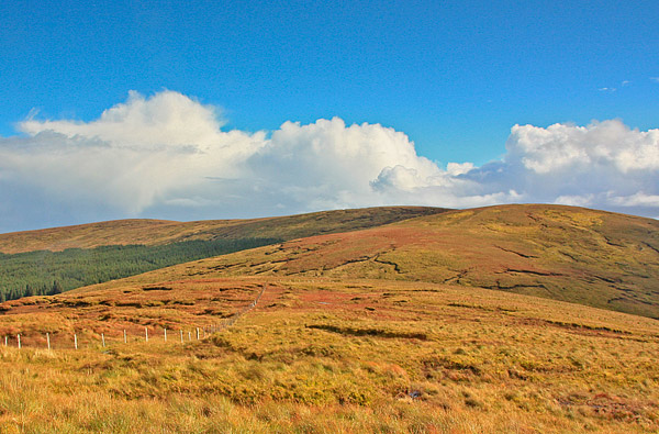
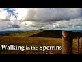
Oughtmore is a typical Sperrin hill with long rounded slopes, apart from its steep eastern flank, and a long broad top of some 2km. The ground is mostly good for walking but can be quite wet in places.

Started this walk on the B40 to Feeney ,which climbs steeply uphill from Moneyeany to cut through Banagher Forest - as reach crest look for peat cutting track on left (B (H718 997)) with barely room to park. Can also park at entrance to forest track ( 
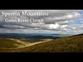
Glenedra Bridge (C706 003)
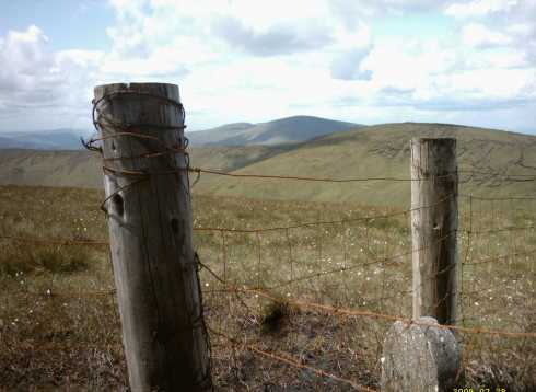
) a little further along the road. Follow this for 20 mins to top of Cragagh Hill (450m). Drop down steeply west into cleft cutting through hill, this contains a little pool with dragon flies patrolling its edges and a bird of prey was hovering nearby. Follow fence uphill and cross another less steep gully, passing the first of many L/Derry Corporation Boundary stones.

It is a fairly gentle climb now to the summit of Spelhoagh (568m) with great views north and east all the way. As reach top view opens out west to the rest of the big Sperrin hills - Mullaghaneany Meenard Sawel and Dart (as sen in the pic). There is a slight drop and reascent as cross to summit of Oughtmore. There is no real feeling of being on the summit due to the lack of any physical structure marking the top, as with many of the neighbouring hills.

Continue to follow the fenceline as it drops down west then NW towards Mullaghaneany. The col is a favourite spot to stop and have lunch perched on the rocks and hopfully some shelter. There is a short stiff climb of some 500ft to Mullaghaneany but is well worth it for the panoramic views. North was Lough Foyle and east across entire length of Antrim Hills to the Belfast Hills across Lough Neagh Basin down to the Mournes and Slieve Gullion in the south and on to Cuilcaigh and up across Donegal with Muckish and Errigal as clear as a bell back up to Slieve Snaght on Inishowen. WOW.

Descend NE along fence and then drop east down open hill to forest edge. At C (H694 992) follow the moor as it intrudes into the forest to reach forest track, turn left and this will bring back to the B40, turn right and follow this quiet high road back to the car. 3.5 hours in all. Linkback: mountainviews.ie/summit/330/comment/1029/
Read Less
Read More

            MountainViews.ie picture about Oughtmore (<em>Ucht Mór</em>)
Derry259 on Oughtmore
by Derry259 7 Jan 2010
Climbed Oughtmore on Sunday 3rd January with "Berghaus Phil"and"Brendan the mountain goat"...........Took usual route of Moneyeaney-Feeny road-(B40) ...........Spent first hour of walk digging B.T.van out of snow drift ,because drivers sat-nav sent him shortest route which just happened to include 3-4 feet of snow......Climbed Craigagh in knee deep snow and crossed onto Spelhoagh then onto Oughtmores vast white summit....After a well earned tea break ,for me in particular (the other two used my size 11,s as snow ploughs to clear a path to summit) We returned along Oughtmores eastern ridge taking in views over Lough Neagh ,Antrim hills and the far of Mourne peaks...After sliding on our backs into the cleft below Craigagh hill (on purpose I might add) we turned left at Derry corporation sign (no L Philip lol) and followed valley around Craigaghs base........BIG MISTAKE.........the snow was waist high ,and it took us 30 minutes to travel a hundred meters although that was partly to do with laughing at each other sinking ......The walk finished as it started with us digging a wayward motorist out of the snow on the way back to the cars ...All in all a brilliant days walking made even better by the snow......... Linkback: mountainviews.ie/summit/330/comment/4330/
Read Less
Read More

            MountainViews.ie picture about Oughtmore (<em>Ucht Mór</em>)
bryanmccabe on Oughtmore
by bryanmccabe 1 Mar 2010
Beautiful mid afternoon view from just below the summit of Oughtmore looking southwest, taken 27/2/10. Snow drifted to 1m and deeper between peat hags on approach. Progress was less than half of normal pace and therefore couldn't complete Oughtmore-Mullaghneany-Meenard horseshoe as hoped. Fell in snow about 30 times, tiring but great fun. Snow shoes would have made for a fabulous day out. Linkback: mountainviews.ie/summit/330/comment/4458/
Read Less
Read More
EDIT Point of Interest
text
Videos


Recent Contributions
x
Conditions and Info
Use of MountainViews is governed by conditions and a privacy policy.
Read general information about the site.
Opinions in material here are not necessarily endorsed by MountainViews.
Hillwalking is a risk sport. Information in comments, walks, shared GPS tracks or about starting places may not be accurate for example as regards safety or access permission. You are responsible for your safety and your permission to walk.
See the credits and list definitions.

OSi logo
OSNI/LPS logo
Open Street Map
(Various variations used.)
British summit data courtesy:
Database of British & Irish Hills