Members and Supporters, the MountainViews Committee requests your help to meet the costs of the website and of other activities such as insured events or publications.
Feature count in area: 57, by county: Cork: 32, Kerry: 36, of which 11 are in both Cork and Kerry,
OSI/LPS Maps: 83, 84, 85, 88
Highest Place: Hungry Hill 682m
Starting Places (51) in area Caha Mountains: Ardgroom, Barley Lake North, Bere Island Pier, Caha Pass, Canshanavoe South, Carriganine, Cashelkeelty Stone Circles Carpark, Castletownbere Lifeboat Harbour, Clashduff River Farm, Coolieragh Harbour Road, Coomadayallig Lake Road N, Coomadayallig Lake Road S, Cooryeen Lane, Cummer Lough East Road, Derreenataggart Stone Circle Road, Dromoghty Lough North, Dunboy Wood, Esk Boreen, Eyeries, Fehanah Lane, Garinish Island Pier, Glantrasna Bridge, Glenbeg Lough N, Glengarriff, Glengarriff Nature Reserve CP, Gleninchaquin Waterfall, Gowlaun Lough, Healy Pass, Healy Pass Hairpin, Ilnacullin Car Park, Kenmare Bridge, Knockacullin Lane, Leahill Bog, Leitrim Beg Standing Stone, Lough Inchiquin SE, Magannagan Stream, Molly Gallivan's Visitor Centre, Nora's Cottage, Old Lansdowne School, Owgarriff River Lane, Peg's Shop, Pooleen Wood Car Park, Red Trout Lake, Reenroe Bridge, River Drimminboy Track, Rossmackowen Bridge, Rossmackowen Cemetery, Shronebirrane Farm, Shronebirrane Road, Toberbanaha, Turner's Rock Tunnel
Summits & other features in area Caha Mountains: Cen: Hungry Hill: Coombane 510m, Derryclancy 554m, Hungry Hill 682m Cen: Knockowen: Cushnaficulla 594m, Glenkeel Top 417m, Knockastumpa 398m, Knockeirky 577m, Knockeirky South Top 523m, Knockowen 658m, Stookeennalackareha 412m E: Glengarriff: Derrynafulla SW 375m, Gowlbeg Mountain 362m, Nareera 530m, Nareera North Top 503m, Nareera South-West Top 505m, Shrone Hill 283m, Sugarloaf Mountain 574m, Sugarloaf Mountain Far West Top 560m, Sugarloaf Mountain West Top 565m N: Coomnadiha: Baurearagh Mountain 489m, Caha Far SE Top 555m, Caha SE Top 585m, Coomnadiha 644m, Coomnalack Top 435m, Cummeenbaun 510m, Droppa 522m, Killane Mountain 537m, Killane Mountain South-West Top 533m, Knockagarrane 414m, Knockreagh 500m N: Knockeirka: Barraduff Mountain 400m, Killaha Mountain 400m, Knockeirka 426m N: Knocknagorraveela: Derrysallagh 410m, Feorus East 474m, Knocknagorraveela 507m, Knocknagorraveela NE Top 464m N: Lauragh: Knockanoughanish 386m, Knockatee 330m S: Castletownbere: Disert 205m, Knockanallig (Bear Island) 267m W: Ardgroom: Derryvour Hill 160m W: Eskatarriff: Coomacloghane 599m, Eskatarriff 600.5m, Eskatarriff East Top 532.7m, Knocknaveacal North Top 509.1m, Knocknaveacal South Top 507.2m, Lackabane 603m, Tooreenbaha 408.7m, Tooreennamna 524m, Tooth Mountain 592m W: Knocknagree: Knocknagree 586m, Knocknagree East Top 461m, Knocknagree SE Top 442m, Lackawee 572m, Maulin 621m, Maulin North Top 579m
Note: this list of places may include island features such as summits, but not
islands as such.
Lackawee, 572mMountain An Leaca Bhuí A name in Irish,
Place Rating ..
(Ir. An Leaca Bhuí [T6000], 'the yellow hillside'), Cork County in Munster province, in Arderin Lists, Lackawee is the 358th highest place in Ireland.
Grid Reference V70391 51736,
OS 1:50k mapsheet 84 Place visited by: 57members, recently by: Krzysztof_K, CusackMargaret, jackos, johncusack, a3642278, chelman7, Taisce, John.geary, mountainmike, annem, eiremountains, nickywood, Superterence, Ulsterpooka, hivisibility
I visited this place: NO (You need to be a logged-in member for this.)
Short or GPS IDs, 6 char: Lckw, 10 char: Lackawee Linkback: https://mountainviews.ie/summit/323/
Gallery for Lackawee (An Leaca Bhuí) and surrounds
Summary
for Lackawee (An Leaca Bhuí):
Not much but exceptional views on a good day.
Summary created by simon3, jackill
2012-10-31 09:20:36
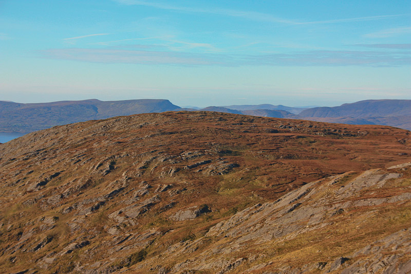
Picture: Lackawee from the SE.
A route from the north starts at the northern end of Glenbeg Lough L GlBeg N (V70103 53800) and following the track there.
A route from the south starts from by leaving your car at Rosmackowen Church Ross Cem (V74200 47209) (Point A) and head up the little borheen immediately after the Church on the Castletownbere side.
Take the left hand fork after a few hundred meters and continue on through a gate following a rough track to the Glas Loughs at about 400 meters elevation.
The face of Knocknagree that looks out over Beara Island is the best approach to take with the least amount of climbing around the rocky folds typical of the area.
Down the rough far side then to a small lake followed by a boggy trot across peat hags and one small hill before the climb to Lackawee's summit.
The view of the Iveragh peninsula on a good day is exceptional.
I walked down the long ,broad back of Maulin and crossed over point 579mtrs before reaching the rounded hump of Lackawee.There are several turf banks to be avoided on the way and again the ground seemed very wet in places. This is a great vantage point from which to view the Beara peninsula ,on a clear day is you can see it from the tip all the way back to the Sugarloaf over Glengarriff. In the distance to the north I could make out the 'Reeks quite clearly The photo is taken fom the north side of Maulin with Lackawee on the left and point 597mtrs in the near distance.
From Lackawee I retraced my steps to the lake on the col under Knocknagree and then skirted around to reach the track at approx 410 mtrs back down to Rosmackowen Church. 5.5 hours and 16.5 kms Linkback: mountainviews.ie/summit/323/comment/1791/
Read Less
Read More
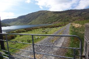
Picture: Lackawee Track
Colin Murphy on Lackawee
by Colin Murphy
15 May 2008
This track at the northern end of Glenbeg Lough provides easy access for an ascent of Lackawee, clearly visible on this beautiful day in May. There is also enough space at this point to park several cars. The gated track leads to some sort of official looking building which appears to be related to the lake in some way (water monitoring/fisheries/ who knows?) but was unmanned when we passed. Just beyond the building, access to the lower slopes of Lackawee is easy and on a day like the one we enjoyed, the view back down to Glenbeg Lough was stunning. Linkback: mountainviews.ie/summit/323/comment/3105/
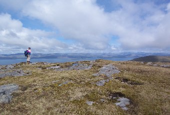
Arrived at Lackawees' summit via Maulin (see Maulin posting for details) and another fine view point it was. We returned to the col, and some soft ground, and traversed pt 579 again to A (V71449 51108), and descended by a small stream, swinging right into the col, then left going round a few ring contours & past a small lough to B (V72442 51161).
As pointed out by Jackill, the ground around the lough to the GPS Ref has some, well, water bed characteristics! Not a place you want to 'break on through to the other side' on. Climb up through the rock , on an easy slope, despite looking more rocky close up than it did from Maulin. And arrive at a splendid summit and view point.
Use of MountainViews is governed by conditions and a privacy policy.
Read general information about the site. Opinions in material here are not necessarily endorsed by MountainViews.
Hillwalking is a risk sport. Information in comments, walks, shared GPS tracks or about starting places may
not be accurate for example as regards safety or access permission. You are responsible for your safety and your permission to walk.
See the credits and list definitions.


 Our Facebook page.