Members and Supporters, the MountainViews Committee requests your help to meet the costs of the website and of other activities such as insured events or publications.
Feature count in area: 31, by county: Leitrim: 22, Sligo: 10, of which 1 is in both Sligo and Leitrim,
OSI/LPS Maps: 16, 17, 25, 26
Highest Place: Truskmore 647m
Starting Places (22) in area Dartry Mountains: Aghavoghil Middle, Arroo Trail CP, Ballaghnatrillick, Ballintrillick Forest, Barrs East, Castletown, Crumpaun, Curraghan Road, Dough Mountain NW, Dough Mountain West, Drumcliff River Road, Eagles Rock, Edenbaun, Glencar Waterfall, Gleniff Horseshoe Road, Lough Cloonaquin North, Luke's Bridge, Mountain Wood, Poulveha River, Thur East, Tormore Car Park, Truskmore Transmitter Entrance
Summits & other features in area Dartry Mountains: N: Truskmore: Gortnagarn 445m, Tievebaun 611m, Truskmore 647m, Truskmore SE Cairn 631m NE: Arroo Keeloges: Aganny Top 482m, Aghalateeve 432m, Agow Top 423m, Arroo Mountain 523m, Conwal North 421m, Crocknagapple 372m, Keeloges 452m NW: Benbulbin: Annacoona Top 597m, Benbulbin 526m, Benwiskin 514m, Benwiskin South Top 508m, Kings Mountain 462m SE: Manorhamilton Hills: Ballaghnabehy Top 413m, Benbo 415m, Dough Mountain 462m, Lackagh Mountain 449m, Larkfield 305m, Naweeloge Top 441m, Thur Mountain 442m SW: Castlegal Hills: Copes Mountain 452m, Crockauns 463m, Hangmans Hill 400m, Keelogyboy Mountain 438m, Keelogyboy Mountain Far East Top 418m, Keelogyboy Mountain NE Top 435m, Keelogyboy Mountain SW Top 417m, Leean Mountain 417m
Note: this list of places may include island features such as summits, but not
islands as such.
Tievebaun, 611mMountain Taobh Bán A name in Irish,
Place Rating ..
(prob. Ir. Taobh Bán [PDT], 'grassy slope'), Leitrim County in Connacht province, in Arderin, Vandeleur-Lynam Lists, Tievebaun is the third highest mountain in the Dartry Mountains area and the 265th highest in Ireland. Tievebaun is the second highest point in county Leitrim.
Grid Reference G76856 49898,
OS 1:50k mapsheet 16 Place visited by: 173members, recently by: Overarroo, orlaithfitz, abeach, Tuigamala, ToughSoles, mdehantschutter, johncusack, a3642278, therealcrow, farmerjoe, Jimmy600leavey, Krzysztof_K, NualaB, MickM45, annem
I visited this place: NO (You need to be a logged-in member for this.)
Longitude: -8.356912, Latitude: 54.397178, Easting: 176856, Northing: 349898,
Prominence: 106m, Isolation: 2.7km ITM: 576822 849900 Bedrock type: Pale orthoquartzitic sandstone, (Glenade Sandstone Formation) Notes on name: Previously Cloghcorragh in MV.
Short or GPS IDs, 6 char: Tvbn, 10 char: Tievebaun Linkback: https://mountainviews.ie/summit/253/
Gallery for Tievebaun (Taobh Bán) and surrounds
Summary
for Tievebaun (Taobh Bán):
Short, sharp climb from the western side
Summary created by Colin Murphy
2011-10-28 16:32:38
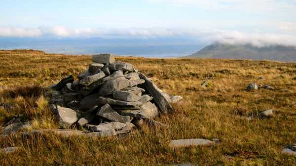
Picture: Tievebaun summit cairn
Summit may be tackled from its western side, parking at A (G747 490), where approaching along the road from the north there is space for a single car on the left hand side of the road, beside which is unfenced open countryside. Head directly west for approx 1km across gently sloping, fairly marshy ground (it was navigable in October after heavy rain). The slope begins to rise steeply at B (G756 490), but the going is mostly firm underfoot. The gradient eases a little at C (G765 490) or approx 450m elevation, eventually levelling out onto a broad summit plateau at 580m elevation. Turn directly north and the summit cairn is reached after an 800m trek across gently sloping, intermittently marshy and solid ground. Time from car to cairn, roughly 1hr 15m.
Climbed June 4th 2006 - Accessed from Truskmore summit having started walk at gates to RTE's private road at 07.00 hrs. Was hoping that the weather would have been as fantastic as it had been on the previous two days (and mornings). However a glance over to Slievemore & Benwhiskin quickly disabused me of that particular notion as a bank of heavy cloud was slowly but surely making its way across the Gleniff valley in my direction. As it turned out by afternoon the hills were bathed in beautifuI sunshine but I had chosen to start early so as to get back to Ballyshannon in time for the start of the gigs in the Rory Gallagher Tribute Festival. Not wanting to take the RTE road (felt like cheating) although I had previously climbed Truskmore from Glencar, I instead cut across the fields and the road (twice) and scaled the side of Truskmore. Steep and tough going but infinitely more rewarding than taking the road. After reaching the summit Trig, which by now was enveloped in cloud. I took a bearing of 25 NNE making straight for Tievebaun summit. Unfortunately the cloud stayed with me throughout the walk only clearing slightly when I returned to Truskmore on my way back. From Truskmore it is a short fairly steep descent down rocky slope, thereafter fairly steady going across col and up slopes of Tievebaun over light trussock grass and the odd small peat hag. Surprisingly, came across wall heading in the general direction of the summit. Not sure if this has something to do with the County boundary or not. Eventually wall veers west. At this point walked through breach in wall and then followed fence up to a few hundred metres short of the summit. Climbed over fence and made way to summit, unmarked and unspectacular. A small locheen/pond parallell to the summit appears to be the only notable feature. Since I couldn't see more than a few metres in any direction I decided to make my way back without any delay. Simply took a reverse bearing of 204 SSW retracing my steps back via Truskmore summit and back down side of Truskmore into Gleniff valley and the car.
Re Wall - A bearing of about 36 NE from Truskmore would bring you to the wall. On a clear day it is possible to see the wall from the summit despite the fact that a large section of it appeared to be missing on the lower slopes, still it ought to be fairly easy to remain on track up towards summit. Linkback: mountainviews.ie/summit/253/comment/2376/
Read Less
Read More
Crash of 42-31420 in 1943
by dp_burke
5 Feb 2017
Just a quick link to the story of 42-31420's crash on Tievebaun as I found it.
http://www.ww2irishaviation.com/42-31420.htm
If you do go up top the small bit of wreckage that is left, please don't remove anymore parts so as to leave some memory of the ten young men who flew with her up there.
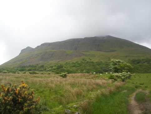
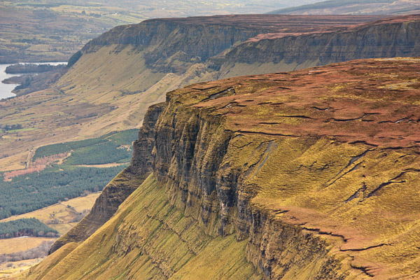
Look out for the great views of the undulating cliff line of the west side of the Glenade valley from the long, boggy saddle between Truskmore and Tievebaun.
The photo was taken in Feb. Linkback: mountainviews.ie/summit/253/comment/6241/
Read Less
Read More
pdtempan on Tievebaun
by pdtempan
15 Nov 2003
Climbed Tievebaun on the same day I did Ben Wiskin and Truskmore. The mountain itself was unexciting and the view was poor as there was a thick heat haze, but it may be much better in fine weather. From Truskmore it's just a question of following a wall. Getting down from Tievbaun was not simple as there was no obvious paths through the farmland on the northern and north-western slopes. Linkback: mountainviews.ie/summit/253/comment/744/
Read Less
Read More
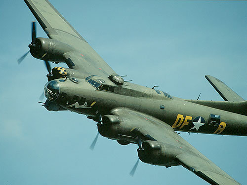
Picture: B-17 crash on Tievebaun 1943
paddyhillsbagger on Tievebaun
by paddyhillsbagger
3 Apr 2010
Update on plane wreckage! Turns out a B-17 like the one pictured crash landed on Tievebaun on a ferry flight from Goose Green to Prestwick on 9th Dec 1943. 3 of a 10 person crew died. 1 crew member was reported living in Washington as recently as 2006. Thanks to www.skynet.ie for info. Linkback: mountainviews.ie/summit/253/comment/4575/
Use of MountainViews is governed by conditions and a privacy policy.
Read general information about the site. Opinions in material here are not necessarily endorsed by MountainViews.
Hillwalking is a risk sport. Information in comments, walks, shared GPS tracks or about starting places may
not be accurate for example as regards safety or access permission. You are responsible for your safety and your permission to walk.
See the credits and list definitions.


 Our Facebook page.