Donation Request 2024

DONATE
Members and Supporters, the MountainViews Committee requests your help to meet the costs of the website and of other activities such as insured events or publications.
You do not have to be logged in to donate.
Features
Nearby features appear when you click the map.
Declutter tracks on map.
Place Search
Video
X
Pub: by
Inishowen Area , Cen: Slieve Snaght Subarea
Feature count in area: 27, by county: Donegal: 27, Derry: 1, of which 1 is in both Derry and Donegal, OSI/LPS Maps: 2, 3, 4, 6, 7
Highest Place: Slieve Snaght 614.6m

Starting Places (43) in area Inishowen:
Adderville Upper, Barnes Bend, Bunacrick, Butlers Bridge, Carnaghan Presbyterian Church, Castruse Upper, Craignacoolagh, Craignamuck, Croaghglengad West, Crockavishane South, Diarmuid and Gráinne's Bed, Doherty's Dún, Dunree Bay Carpark, EEl Hole, Effishmore Upper, Evishbreedy Bridge, Five Fingers Strand, Gap of Mamore Grotto, Gap of Mamore Road, Gap of Mamore Viewpoint, Glack, Glasmullan, Golan Bridge Track, Goorey Hill, Grania's Gap, Gransha Árd, Green Hill, Leamacrossan Hill East, Lisfannon Beach, Lough Shivnagh, Lough Turk North, Magilligan Point View, Meenabroagh, Meenyollan River, Moor House, Mullagh, Pincher's Corner, Rashenny, Roosky Upper, Rowantree Hill, St Michael's Church, Stroove Beach, Tullagh Beach

Summits & other features in area Inishowen:
Cen: Slieve Snaght: Damph 420m, Slieve Main 514m, Slieve Snaght 614.6m
N: Malin: Croaghglengad 259m, Crockalough 282m, Soldiers hill 174m
NE: North East Inishowen: Crockavishane 322m, Crocknasmug 327.5m, Grinlieve 371m
NW: Urris: Binnion 250m, Bulbin 494m, Coolcross Hill 291m, Croaghcarragh 400m, Crockmain 460m, Dunaff Hill 230m, Mamore Hill 423m, Raghtin More 502m, Slievekeeragh 389m, Urris Hills 417m
S: Iskaheen: Crockglass 397m, Eskaheen Mountain 418m, Greenan Mountain 241m, Holywell Hill 260m, Inch Top 222m, Leamacrossan Hill 392m, Mouldy Hill 312m, Scalp Mountain 484m

Note: this list of places may include island features such as summits, but not islands as such.
Rating graphic.
Slieve Snaght, 614.6m Mountain Sliabh Sneachta A name in Irish,
Place Rating ..
(Ir. Sliabh Sneachta [DUPN], 'mountain of snow'), Donegal County in Ulster province, in Arderin, Vandeleur-Lynam Lists, Slieve Snaght is the highest mountain in the Inishowen area and the 261st highest in Ireland.
Grid Reference C42444 39017, OS 1:50k mapsheet 3
Place visited by: 215 members, recently by: CianDavis, rhw, MeabhTiernan, Carolineswalsh, ToughSoles, Sonyalaw, mdehantschutter, ChrisC, Beti13, Ansarlodge, Jimmy600leavey, noelcurt, Krzysztof_K, IncaHoots, TessDws
I visited this place: NO (You need to be a logged-in member for this.)
Longitude: -7.334304, Latitude: 55.196404, Easting: 242444, Northing: 439017, Prominence: 600m,  Isolation: 1.6km, Has trig pillar
ITM: 642384 938997
Bedrock type: Psammitic schist with pebbly grit beds, (Upper Crana Quartzite Formation)
Notes on name: There is a tradition of pilgrimage to Slieve Snaght and a well near the summit is associated with a cure for blindness (Tobar na Súl) [Colhoun]. See Máire MacNeill, 'The Festival of Lughnasa' (pp. 145-46) for details of the festive assembly on Slieve Snaght. The mountain is said to be so named because snow lies on it until the fair of Carndonagh, which is the 21st of May [OSNB]. Its satellites are Slieve Main, Crocknamaddy and Damph. A limelight erected on the summit of Slieve Snaght was observed on Divis by the Ordnance Survey in 1825. This enabled them to establish trigonometrical baselines and link the Irish survey to the English one, before going on to survey the whole country of Ireland.
  Short or GPS IDs, 6 char: Slv615, 10 char: SlvSngh615

Linkback: https://mountainviews.ie/summit/250/
Gallery for Slieve Snaght (Sliabh Sneachta) and surrounds
Summary for Slieve Snaght (Sliabh Sneachta): Boggy footed summit with great sea and mountain views.
Summary created by simon3 2021-08-22 07:58:32
            MountainViews.ie picture about Slieve Snaght (<em>Sliabh Sneachta</em>)
Picture: Slieve Snaght from the South.
Many routes are available for this summit, the only Vandeleur-Lynam on the Inishowen peninsula.
One place to start is from the unfenced road at around A (C4426 3722). While not an inspiring route due to the wet untracked and vegetated terrain, this has the merit of making it easily possible to also go to Damph.

Another eastern route uses the bog road starting at Meeny Rv (C450 393).
From the west at the Slieve Sneacht Centre in Dumfries where there is parking at B (C3854 3895)
Or from near a derelict cottage at Cr'muck (C392 368).
From the north it is possible to start at Golan Tr (C42498 41978) or Cr'cool (C408 423)

The summit has a collection of amateur cairns built from the plentiful supply of loose rock near the top. Near the trig pillar is a well which supposedly has a cure for eye problems (or maybe a cause?). There are fine views to the Loughs Swilly and Foyle, to the sea, to much of Inishowen, to Muckish and to the Sperrins.
Linkback: mountainviews.ie/summit/250/comment/5010/
Member Comments for Slieve Snaght (Sliabh Sneachta)
Comment create / edit display placeholder

            MountainViews.ie picture about Slieve Snaght (<em>Sliabh Sneachta</em>)
Picture: the sunset seen from Slieve Snaght
Sunset, there will be no repeat.
by Krzysztof_K 27 Apr 2023
I reached the foot of the mountain by the road marked 'dead end' C (C38868 40108). After driving about 600m I reached the gate. So far, I have walked through gates marked 'close gate' many times, but this time I drove through by a car. And, after closing the gate D (C39521 40119) behind me, when I found myself at the crossroads of dirt roads, right at the bottom of the mountains in front of me, it was like in another world that I reached with my vehicle, leaving the whole civilization behind me.
It was just before 8 p.m. A quick glance at the calendar revealed that sunset was supposed to be at 8:50 p.m. I can't do this, I thought. I walked briskly towards the top. A few hundred meters along a dirt road, then avoiding clumps of grass and peat holes. It wasn't that bad, it hadn't rained for a long time so there was no mud, but I fell into the swamps two or three times. Time, however, passed inexorably and the sun was getting closer and closer to the horizon. The climb to Slieve Snaght is quite steep from this side. I have the sun setting behind my back so I didn't really see what was going on there. The last meters to the top, long strides on the stones and I found myself on the top where there were lots of small piles of stones. I quickly located the main peak and when I looked back the sun was just above the horizon.
I took one picture... and the sun went down. Just one take, not even a chance for a repeat. Linkback: mountainviews.ie/summit/250/comment/23938/
Read Less
Read More

            MountainViews.ie picture about Slieve Snaght (<em>Sliabh Sneachta</em>)
Picture: the fantastic summit of S Snaght
gerrym on Slieve Snaght
by gerrym 10 Oct 2008
'Walk Guide West of Ireland' (P.Simms & T. Whilde) gives a route from the east at E (C443 369) but I took the advice of Paddy Dillon in 'The Mountains of Ireland' where he describes this as "the shortest, boggiest and least inspiring route". I started from a bog track on the west at Cr'cool (C408 423), can park here where track forks. Walk up track , turn left and ford stream, turn right and at small quarry head onto hillside in front , aiming for some large boulders. There are a series of rises separated by flat areas of bog. The ground becomes rockier as approach the minor summit of Slieve Snaghtbeg (505 m) which is topped by a cairn. Cross over gap to the south for the climb to the summit. The summit is a weird scape of rocks and boulders, with cairns and very large walled trig point - it does feel other worldly (see pic for a little flavour). There are good views west across to Ragtin More and Urris Hills behind the shapely Bulbin and south to neighbouring Slieve Main. On a good day I am sure the views would be much more extensive. One and a half hours to the top and it is only logical to take in Slieve Main as well.No one else on the hill when I climbed on 23rd April 2004 Linkback: mountainviews.ie/summit/250/comment/1069/
Read Less
Read More

Innishowen's Finest!
by Heathcliff 30 Mar 2016
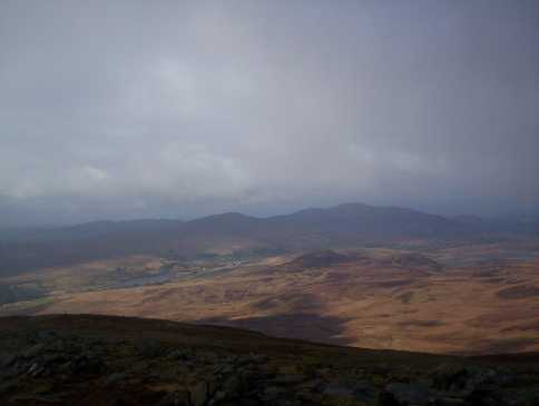
Heathcliff:16/03/2016 climbed Slieve Snaght (615m) via Slieve Snaghtbeg (505m) in warm sunshine and descended via Slieve Main( 514m) after a wonderful 4/5 hour walk! A 12 km trek with a total ascent of approx 650m,using OSi map no.3.
I parked at Drumfree(Drumfries on road sign) School on R244 between Carndonagh and Buncrana at 
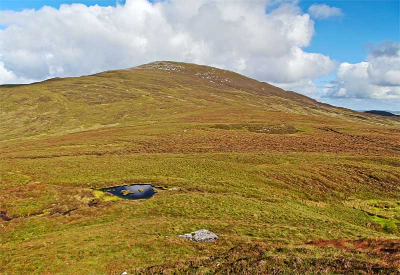
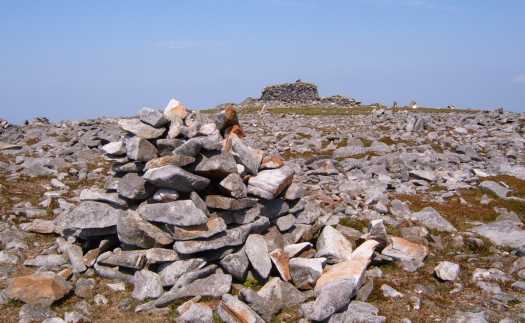
F (C386 392).I headed southwards(10 m) in direction of Buncrana before turning northeastwards up a narrow lane way. Tarmac soon turns to stony track and you cross two metal gates before veering right at a crossroads,signed Slieve Snaght. At the end of this track you are left to decide your route up the mountain! I chose to ascend gradually up grassy/heathery slopes northeastwards before looping around to climb Slieve Snaghtbeg southwestwards up moderately steep slopes,a flat section,and then a steep rise to the summit cairn.
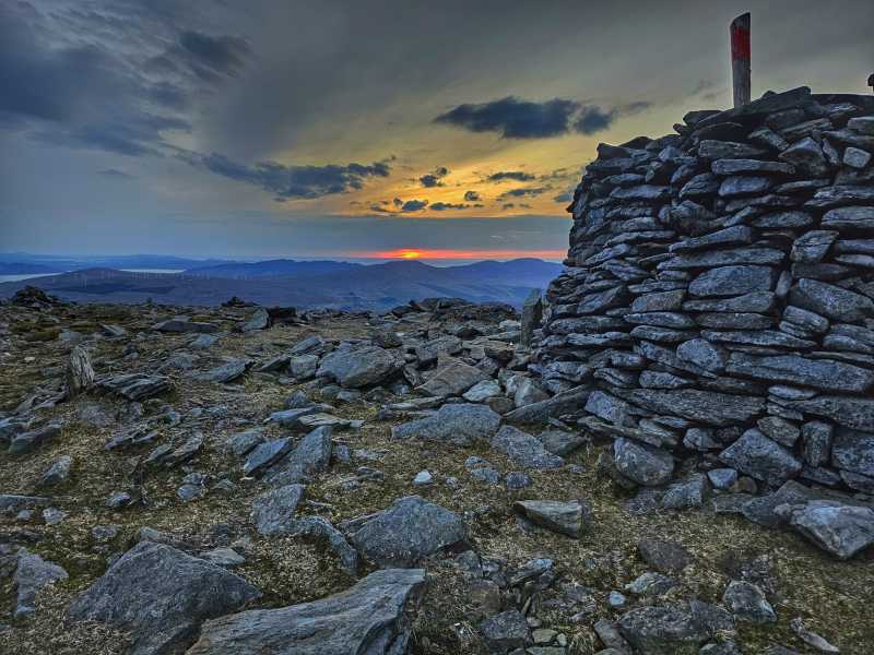
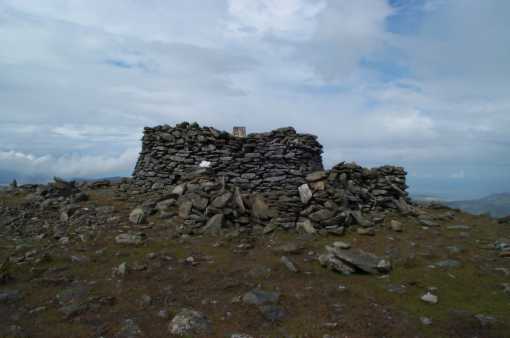
From Snaghtbeg I descended southwards along flat grassy section before turning southeast up peaty slopes to rock strewn summit with a stone shelter and trig point. A great spot to pause for lunch and take in the extensive views.
Southwestwards from the summit lies Slieve Main's 'whaleback top'. To reach it descend south and then southwestwards down a steepish slope to a peaty col and a stream which you cross. Pick your route and ascend up a grassy slope to the broad summit(no trig point)!
A steepish slope northeastwards and then northwestwards brings you to a flat area. On a clear day you should have already been able to spot the track you left earlier in the day,and now head for this, keeping well to the right of some trees.
If you are thirsty the North Pole Bar is a short distance from where you parked your car. The pub has an interesting history and I think it is a ' listed' building. Altogether a really great walk up Innishowens highest mountain!!!!! Linkback: mountainviews.ie/summit/250/comment/18480/
Read Less
Read More

            MountainViews.ie picture about Slieve Snaght (<em>Sliabh Sneachta</em>)
padodes on Slieve Snaght
by padodes 2 Jul 2007
This is the summit trig pillar on Slieve Snaght (Inishowen), with the peculiarity of being almost fully entombed in a cairn-like structure. Nearby I found the equally unusual feature of a pile of tractor and car tyres whose purpose was as unclear as it was unsightly. The jagged spikes of rock that cover the top (set up by pilgrims or just a whim of Mother Nature?) would make a dream-bed for a fakir. I started up from the E side, from a point on the bog road at Meeny Rv (C450 393), walking over marshy land at first before climbing steeply up to the summit. There are long sheep fences on this side of the mountain, with ne'er a stile in sight, but enterprising sheep don't seem to have found that a great obstacle to free passage. From the top, I walked south to Slieve Main and then triangulated back to my point of departure. Damph would have been a further obvious top to visit, but on the hot and rainy day I did this walk the combination of bog and fence and Donegal midges got the better of me in the end. Linkback: mountainviews.ie/summit/250/comment/2759/
Read Less
Read More

            MountainViews.ie picture about Slieve Snaght (<em>Sliabh Sneachta</em>)
Picture: Looking over Mintiaghs Lough & Bulbin towards Urris Hills, Raghtin More & Raghtin Beg from Snaght
eflanaga on Slieve Snaght
by eflanaga 26 Feb 2006
(Climbed 06.02.24) Having topped Crocknamaddy & Slieve Main (first part of walk) I reached the col beneath Slieve Snaght (G (C421 379)). From here it should have been a straightforward ascent, similar in nature to that I had just negotiated to make the top of Slieve Main. However, the climb was now a little further east than before and I wasn’t afforded the protection I had enjoyed while climbing Main. It made for a pretty miserable ascent. The rain, wind, and most notably the gusts which felt much stronger than the predicted 15-20 mph, appeared intent on hurling me of the mountain. Cold and feeling suitably miserable I approached the summit entreating Zeus (Weather God) to at least have the good grace to afford me a clear spell on the summit to take some pictures. He must have been listening because just as I cleared the top, the clouds, as if by magic were swept away, revealing the rock strewn summit, with its numerous mini-cairns and the large rock structure surrounding the Trig point. Unfortunately, while Zeus may have been magnanimous, my camera batteries and the spares decided to chuck a collective wobbly. After some minutes of violent shaking I managed to get one set to take half a dozen pics before they packed it in completely. Being cold and miserable I decided not to dawdle any longer at the Trig point and set a bearing of 246 degrees SW for the 4.5K trek back to Fallask. This route took me west of Slieve Main crossing the Sruthancarragh (H (C415 385)) after about 1K from the summit. Maintaining the same bearing crossing slightly marshy ground at times, I reached the Kinnego Rd via a track in a newly planted forested area. From here it was a five minute walk back to the car and time for a hot drink, quick lunch and twenty minute drive (via Clonmany) to Urrismenagh, the start of the final leg to the summit of Raghtin More (See Raghtin More for final part of walk). Linkback: mountainviews.ie/summit/250/comment/2199/
Read Less
Read More
EDIT Point of Interest
text
Videos


Recent Contributions
x
Conditions and Info
Use of MountainViews is governed by conditions and a privacy policy.
Read general information about the site.
Opinions in material here are not necessarily endorsed by MountainViews.
Hillwalking is a risk sport. Information in comments, walks, shared GPS tracks or about starting places may not be accurate for example as regards safety or access permission. You are responsible for your safety and your permission to walk.
See the credits and list definitions.

OSi logo
OSNI/LPS logo
Open Street Map
(Various variations used.)
British summit data courtesy:
Database of British & Irish Hills