Cookies.
This website uses cookies, which are small text files that the website puts on your device to facilitate operation. Cookies help us provide a better service to you. They are used to track general user traffic information and to help the website function properly.
Features
Nearby features appear when you click the map.
Declutter tracks on map.
Place Search
Video
X
Pub: by
Sperrin Mountains Area , NE Cen: Glenelly North East Subarea
Feature count in area: 64, by county: Derry: 34, Tyrone: 39, of which 9 are in both Derry and Tyrone, OSI/LPS Maps: 12, 13, 6, 7, 8
Highest Place: Sawel 678m

Starting Places (21) in area Sperrin Mountains:
Altinure Road, Banagher Glen Nature Reserve, Barnes Gap Car Park, Crocknakin, Drumnaspar Picnic CP, Glenchiel Road, Glenedra Bridge, Glenelly Road, Parkreagh, Goles Road, Lough Ouske, Moneyneany Village, Moydamlaght Forest, Moydamlaght Road, Mullaghmore, Mullaghbane, Spaltindoagh, Sperrin Hamlet, Sperrin Heritage Centre, Sperrin Heritage Centre W, Sperrin Road, Barnes Top, Sperrin Road, Glashagh Bridge, Sperrin Road, Sperrin

Summits & other features in area Sperrin Mountains:
E: Magherafelt Hills: Slieve Gallion NE Top 493.6m
E: Magherafelt Hills: Slieve Gallion 526.6m
N: Claudy Hills: Crockdooish 321m, Curradrolan Hill 270m, Eglish 277m, Letterlogher 249m, Mullaghmeash Hill 244m, Slieveboy 259m, Straid Hill 303m
NE Cen: Glenelly North East: Barnes Top 456m, Craigagh Hill 460m, Crockbrack 526.1m, Knockanbane Mountain 441m, Meenard Mountain 620m, Meenard Mtn W Top 480m, Mullaghaneany 627m, Mullaghash 480m, Mullaghsallagh 485m, Oughtmore 569m, Spelhoagh 568m
NE: Glenshane North: Benbradagh 465m, Boviel Top 454m, Carn Hill 448m, Carntogher 464m, Moneyoran Hill 414m
NE: Glenshane South: Bohilbreaga 478m, Coolnasillagh Mountain 423m, Corick Mountain 430m, Crockalougha 407m, Mullaghmore 550m, White Mountain 537m
NW Cen: Glenelly North West: Dart Mountain 619m, Dart Mountain North-West Top 525m, Learmount Mountain 489m, Learmount Mountain South Top 492m, Mullaghasturrakeen 581m, Mullaghcarbatagh 517m, Mullaghclogha 635m, Mullaghclogher 572m, Mullaghdoo 568m, Sawel 678m
NW: Maheramason Hills: Clondermot Hill 220m, Gortmonly Hill 218m, Slievekirk 370m
SE Cen: Glenelly South East: Carnanelly 562m, Carnanelly West Top 503.4m, Mullaghbane 467m, Mullaghturk 416m
SE: Cookstown Hills: Cregganconroe 300m, Fir Mountain 362m, Oughtmore 382m
SW Cen: Glenelly South West: Clogherny Top 408m, Craignamaddy 385m, Crocknamoghil 335m, Mullaghbolig 442m, Spaltindoagh 420m
SW: Mullaghcarn: Curraghchosaly Mountain 416m, Mullaghcarn 542m, Mullaghcarn South Top 525m
SW: Newtownstewart Hills: Bessy Bell 420m, Mullaghcroy 242m
W: Strabane: Balix Hill 403m, Knockavoe 296m, Owenreagh Hill 400m

Note: this list of places may include island features such as summits, but not islands as such.
Rating graphic.
Meenard Mountain, 620m Mountain Mín Ard A name in Irish,
Place Rating ..
(Ir. Mín Ard + Eng. Mountain [OSM], 'high mountain pasture' ), Derry/ Tyrone County in Ulster province, in Arderin, Vandeleur-Lynam Lists, Meenard Mountain is the 256th highest place in Ireland. Meenard Mountain is the third highest point in county Derry.
Grid Reference H67290 98565, OS 1:50k mapsheet 13
Place visited by: 156 members, recently by: Aidan_Ennis, discovering_dann, bowler, Jimmy600leavey, rhw, Prem, trostanite, ToughSoles, Tricia-Mulligan, Lgr, MickM45, Krzysztof_K, Paddym99, Sperrinwalker, garybuz
I visited this place: NO (You need to be a logged-in member for this.)
Longitude: -6.953797, Latitude: 54.830392, Easting: 267290, Northing: 398565, Prominence: 85m,  Isolation: 1.2km
ITM: 667219 898558
Bedrock type: Psammite & semipellite, (Dart Formation)

  Short or GPS IDs, 6 char: MnrdMn, 10 char: MnrdMntn

Linkback: https://mountainviews.ie/summit/243/
Gallery for Meenard Mountain (Mín Ard) and surrounds
Summary for Meenard Mountain (Mín Ard): Sperrin Views
Summary created by simon3, march-fixer 01 Oct, 2012
            MountainViews.ie picture about Meenard Mountain (Mín Ard)
Picture: Meenard glitters in autumn light.
This is readily accessible as part of an extended walk to Mullaghaneany mountain starting from the B40 road at A (C70607 00374) The views from here are superb, both north, west and south, with a real sense of wild remoteness.

The summit can be reached by just following the fence line NW and then SW from Mullaghaneany. This can be most useful in poor visibility. The going can be soggy along the fence on the climb up from the col. It is best to keep slightly away from the fence line or use some nimble footwork.

There is a nice little cairn on the summit which affords a useful wind-break for a couple of individuals.

Unless you are heading west on the track to Meenard W Top, there is little reason to proceed further, but you could retrace your steps and head back via Oughtmore and Craighagh Hill for an excellent circuit taking around 5 hours in all.

Geology: See reference for Mullaghaneany mountain.
Linkback: mountainviews.ie/summit/243/comment/5003/
Member Comments for Meenard Mountain (Mín Ard)

            MountainViews.ie picture about Meenard Mountain (Mín Ard)
eflanaga on Meenard Mountain
by eflanaga 9 Feb 2007
Walk commenced at entrance to Altbritain Forest and ascent via track & open hillside to Mullaghaneany summit. Crossing the fence near Mullaghneany’ summit IB (H68586 98620) we walked adjacent to the fence dropping to the col leading on to Meenard. Generally, I would tend to leave the fence at this stage and make my way across the mountain but decided on the day to follow the fence around to the point on its north-eastern flank where it turns to climb up Meenard. The ground close to the fence on the ascent is difficult with lots of peat-hags to negotiate. I found that by staying roughly about 100m to the left of the fence the ground improved greatly after about 150m of climb making the going much easier to the summit IC (H67284 98562) which is marked by a small cairn of white stones atop a peat-hag. Again, (following a short period where mist enveloped the summit) as on Mulaghaneany, we were greeted by fantastic panoramic views in all directions. Sawel and Dart (with a peculiar cloud over it) were bathed in sunshine, while in the distance across the valley, to the north-east, Benbradagh’s long ridge & snout lay invitingly. Mist beyond Benbradagh stole away the chance to see Binevenagh, Lough Foyle and the Innishowen Hills in Donegal often clearly visible from here. From here we were going to make for some of the area’s less well known and infrequently visited hills, new territory for us despite our experience in the Sperrins. Principal among these was Mullaghgash, a fantastic looking mountain and, which at 485m, should hopefully make the proposed 400+ section soon to be included here on the Mountain Views site. I will include a description of the route there when that resource is available. Linkback: mountainviews.ie/summit/243/comment/2608/
Read Less
Read More

            MountainViews.ie picture about Meenard Mountain (Mín Ard)
No Meen Feat
by gerrym 23 Jan 2014
Menard is a mountain that on its own does not have the X Factor. Thankfully there is a great supporting cast to put on a show that might just be unforgettable. I have approached the mountain from all cardinal compass points and in the process tackled the hills and mountains that surround Meenard.

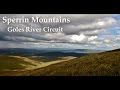
The most satisfying route was from Goles Forest to the S, tramping over Mullaghsallagh, Oughtmore and Mullaghaneany before the top of Meenard. This brings the highlight of dropping nearly due S from the summit to the steep ravines and waterfalls of Golnasivagh Burn which travels through a wonderfully bleak valley. The abandoned hamlet of Goles stands monument to this bleak place and the Goles River is then followed to return.

Banagher Forest to the E also provides a great approach over Oughtmore and Mullaghaneany with a bit of back tracking, though a different route can be followed back through the forest.

From the N the Owenbeg River can be followed to take in Mullaghgash and Barnes Top before heading for the heights of Meenard. This allowed me to take in a couple of new tops and approach from a new angle.

Perhaps the least adventurous would be from the high parking spot found to the W at the col with Sawel, unless the tops further E could be included.

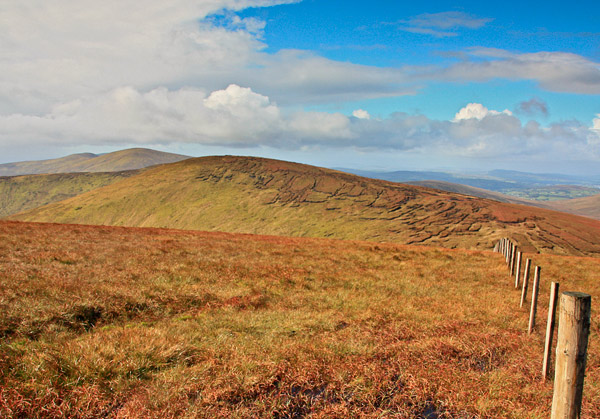
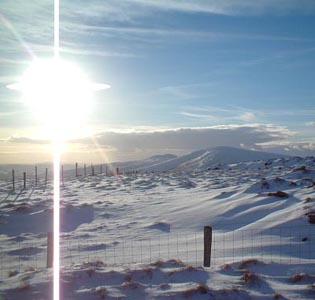
A trusty fencline traverses the top of Meenard and a small cairn has grown a little bigger in recent years. Boggy ground and peat hags are a distinct feature, though these take on an amazing hue in frozen times.

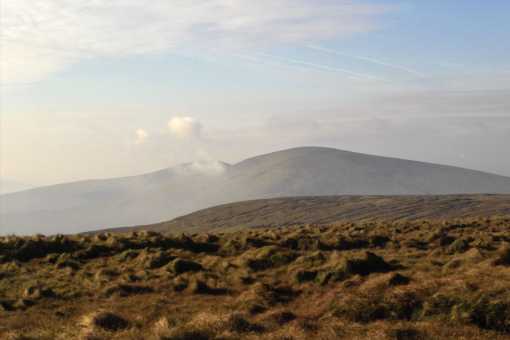
The Sperrins are all about views and from the topviews reach to the Donegal Hills to the west with Muckish very distinct, north to Inishowen and Lough Foyle and east to Knocklayd at Ballycastle. The Scottish islands further north are even visible on occasion. South the line of the Mournes can be seen to stretch out to Slieve Gullion. Linkback: mountainviews.ie/summit/243/comment/876/
Read Less
Read More

            MountainViews.ie picture about Meenard Mountain (Mín Ard)
Picture: Front row of scrum?
ice cold after sAwELX
by Derry259 23 May 2010
Climbed Meenard as part of a proposed walk from Dart to Oughtmore via Sawel,Meenard and Mullaghaneaney.I say proposed because unfortunately Mucky Trousers was under strict orders from the "petticoat government" (his words) to be home for two, so when we reached Meenard's summit at one a hasty route back to Two Shovels' car was taken. But then again you can't sleep in and still do all you had planned to do .(isnt that right Brendan)
Tough walk starting from Crockahilly road a long long ascent of Dart before crossing onto Sawel ,down to Barne's road up past the County Rock and up Meenard before skirting round Mullaghaneaney and taking the forestry track to the Feeny ,Moneyneaney road.
Great walk, brilliant weather , good craic, and four ice cold cans of coke which two shovels had kept in his car cool box as a wee treat on walks conclusion.As Sir John Mills said in Ice cold in Alex " worth waiting for" although I can't recall him burping like Big Frank after his pint of Carlsberg..........please excuse poetic license in title :-) Linkback: mountainviews.ie/summit/243/comment/5820/
Read Less
Read More
EDIT Point of Interest
text
Videos


Users Online

Guests online: 230
Recent Contributions
x
Conditions and Info
Use of MountainViews is governed by conditions and a privacy policy.
Read general information about the site.
Opinions in material here are not necessarily endorsed by MountainViews.
Hillwalking is a risk sport. Information in comments, walks, shared GPS tracks or about starting places may not be accurate for example as regards safety or access permission. You are responsible for your safety and your permission to walk.
See the credits and list definitions.

OSi logo
OSNI/LPS logo
Open Street Map
(Various variations used.)
British summit data courtesy:
Database of British & Irish Hills